| Please join us at the 23rd annual Black Diamond Fall Fundraiser Party Thursday Sept 15. Tickets are on sale now here, at the Black Diamond store & at REI. Special bonus raffle for online ticket purchasers! |
| Please join us at the 23rd annual Black Diamond Fall Fundraiser Party Thursday Sept 15. Tickets are on sale now here, at the Black Diamond store & at REI. Special bonus raffle for online ticket purchasers! |
| Advisory: Moab Area Mountains | Issued by Eric Trenbeath for Monday - March 21, 2016 - 6:50am |
|---|

|
bottom line Overall, the avalanche danger is generally LOW but unstable snow may exist on isolated terrain features. Remain on the lookout for isolated wind slabs on the lee sides of terrain features if you venture into extreme, upper elevation terrain.
|
 |
special announcement This advisory is based on field observations performed on Sunday, March 20 and will be updated next on Wednesday, March 23. Please help guide our discussions of website maintenance, upgrades or possible changes in coming years. Take this brief survey. As a way of saying thanks we'll be raffling a free avalanche class and other free stuff like hats, beanies, water bottles, etc |
 |
current conditions
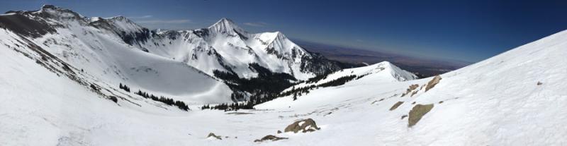
Looking down a south facing gully off Laurel Mountain with Mount Tukuhnikivatz in the distance. It was quite a weekend in the La Sal Mountains with sunny skies and mostly stable snow. People were getting out and about and doing it all. On Sunday, I got up high in Gold Basin and saw numerous parties ascending Mount Tukuhnikivatz, as well dropping big lines off Tukno, into Talking Mountain Cirque, and into Horse Creek. Local observers also reported seeing a snowmoblile at close to 12,000' on the ridge above Middle Cirque on Saturday. In short, people are getting after it, and getting away with it. Snow conditons on north facing aspects, though mostly stable, are quite variable having sustained a fair amount of wind damage over the past week. The real ticket right now is corn snow on SE-S-W aspects. For best conditions, drop just below treeline where the lack of wind has allowed for a great melt freeze cycle. With a change in the weather approaching, Monday will be your last day for this. Winds, temperature and humidity on Pre-Laurel Peak New snow totals, temperature and humidity in Gold Basin Total snow depth and temperature at Geyser Pass Trailhead
|
 |
recent activity
|
| type | aspect/elevation | characteristics |
|---|

|
|
LIKELIHOOD
 LIKELY
UNLIKELY
SIZE
 LARGE
SMALL
TREND
 INCREASING DANGER
SAME
DECREASING DANGER
|
|
description
The avalanche danger is generally low at this time and people are getting into more extreme terrain without incident. However, unstable snow may still exist on isolated terrain features. If you are pushing it into more extreme terrain, particularly at upper elevations, on slopes that have a N-E aspect, remain on the lookout for isolated wind slabs, or areas where older persistent slabs may be resting on top of weak, sugary, faceted snow. Even a shallow slab release in these areas could produce a terrible ride with dire consequences.
|
 |
weather A high pressure ridge will continue to dominate the region through Monday. Southwest winds will increase ahaead of a Pacific storm system that will move in from the Great Basin on Tuesday. The brunt will affect mainly northern Utah and north central Colorado. We should see clouds Tuesday morning, with a chance of snow and wind continuing into Wednesday. We may see a stronger system in our area by the weekend. Monday Mostly sunny, with a high near 43. Windy, with a southwest wind 25 to 35 mph, with gusts as high as 50 mph. Monday Night A 10 percent chance of snow after 4am. Mostly cloudy, with a low around 27. Very windy, with a west southwest wind 35 to 45 mph, with gusts as high as 65 mph. Tuesday Snow likely, mainly after 1pm. Mostly cloudy, with a high near 33. Very windy, with a southwest wind 35 to 45 mph, with gusts as high as 60 mph. Chance of precipitation is 70%. New snow accumulation of less than one inch possible. Tuesday Night Snow likely, mainly before midnight. Mostly cloudy, with a low around 14. Windy, with a northwest wind 30 to 35 mph decreasing to 20 to 25 mph after midnight. Winds could gust as high as 50 mph. Chance of precipitation is 70%. Wednesday A 50 percent chance of snow. Partly sunny, with a high near 22. Blustery. |
| general announcements Road Conditions: The road to Geyser Pass trailhead is mostly dry and down to the dirt. The upper end gets a little muddy by afternoon. To post an observation go here. You can view Moab observations here. You can also give me a call on my cell phone at 801-647-8896 To receive this advisory by email go here. This information does not apply to developed ski areas or highways where avalanche control is normally done. This advisory is from the U.S.D.A. Forest Service, which is solely responsible for its content. This advisory describes general avalanche conditions and local variations always exist. |