| Please join us at the 23rd annual Black Diamond Fall Fundraiser Party Thursday Sept 15. Tickets are on sale now here, at the Black Diamond store & at REI. Special bonus raffle for online ticket purchasers! |
| Please join us at the 23rd annual Black Diamond Fall Fundraiser Party Thursday Sept 15. Tickets are on sale now here, at the Black Diamond store & at REI. Special bonus raffle for online ticket purchasers! |
| Advisory: Moab Area Mountains | Issued by Eric Trenbeath for Saturday - March 19, 2016 - 7:16am |
|---|

|
bottom line Overall, the avalanche danger is generally LOW but unstable snow may exist on isolated terrain features, particularly in areas of steep, extreme, upper elevation, terrain.
|
 |
special announcement Please help guide our discussions of website maintenance, upgrades or possible changes in coming years. Take this brief survey. As a way of saying thanks we'll be raffling a free avalanche class and other free stuff like hats, beanies, water bottles, etc |
 |
current conditions
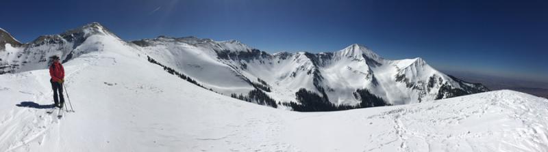
UAC Director Mark Staples strikes his best Monty Atwater on the summit of Pre Laurel Peak. Skies are clear this morning and NW winds are averaging 10-15 mph with gusts into the 20's along ridgetops. Temps are again cool this morning, and it's 25 degrees at the Geyser Pass trailhead. Look for it to warm up to near 40 at 10,000' today for a beautiful, if not a bit breezy, day in the mountains. Mark Staples and I took a high tour around greater Gold Basin on Thursday, and found mixed but decent riding conditions. The dusting of snow from earlier in the week finally melted into the sun exposed slopes by mid-day, and good corn conditions are setting up on SE-S-W aspects. For the best corn snow, drop below the ridgetops and get out of the wind. We found dry snow on upper elevation, northerly aspects, but the wind has certainly had it's way with it since last weekend. Don't be deceived by smooth looking crusted areas - instead look for snow that is lightly etched for the softest, most turnable snow.
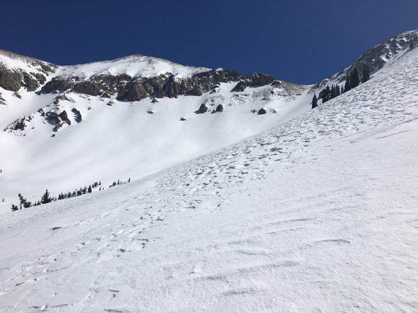
Looks can be deceiving. The softest, least crusted snow often has an etched appearance such as this. Winds, temperature and humidity on Pre-Laurel Peak New snow totals, temperature and humidity in Gold Basin Total snow depth and temperature at Geyser Pass Trailhead
|
 |
recent activity
|
| type | aspect/elevation | characteristics |
|---|

|
|
LIKELIHOOD
 LIKELY
UNLIKELY
SIZE
 LARGE
SMALL
TREND
 INCREASING DANGER
SAME
DECREASING DANGER
|
|
description
In our travels on Thursday, we found little to be concerned with. We noted isolated wind slabs on upper elevation northerly aspects, but they were fairly obvious, easy to detect, and are for the most part, welded into place. I still wouldn't jump on one in areas of more extreme terrain, where the possibility of release could carry you over a cliff or rock band, or take you for a long ride down a very steep slope. Look for the usual smooth rounded pillows, or ribbons of wind drifted snow on the lee sides of sub ridges, gully walls or rock bands, and avoid them in areas of steep, radical terrain. In very isolated instances, one of these slabs could also release on faceted, sugary snow in areas where the snowpack is very shallow and weak. Of note for the future - we observed some loose, near surface facets beneath a thin wind crust, that could develop into our next weak layer should we ever see new snow, or if new wind slabs form on top. .
|
 |
weather Sunny and breezy conditions are in store for the weekend. Temperatures will climb higher each day to near 50 degrees at 10,000' by Monday. A storm system that looks to affect mainly areas to the north will move into the region on Tuesday night. Today Sunny, with a high near 33. Breezy, with a north northwest wind 10 to 20 mph, with gusts as high as 30 mph. Tonight Mostly clear, with a low around 23. West northwest wind 10 to 15 mph, with gusts as high as 25 mph. Sunday Sunny, with a high near 41. West northwest wind 10 to 15 mph becoming south in the morning. Winds could gust as high as 25 mph. Sunday Night Mostly clear, with a low around 32. Breezy, with a south southwest wind 15 to 20 mph, with gusts as high as 35 mph. Monday Mostly sunny, with a high near 46. Windy, with a southwest wind 15 to 20 mph increasing to 25 to 30 mph in the afternoon. Winds could gust as high as 50 mph. |
| general announcements Road Conditions: The road is a mix of dirt at lower elevations that turns to mud as the day progresses. To post an observation go here. You can view Moab observations here. You can also give me a call on my cell phone at 801-647-8896 To receive this advisory by email go here. This information does not apply to developed ski areas or highways where avalanche control is normally done. This advisory is from the U.S.D.A. Forest Service, which is solely responsible for its content. This advisory describes general avalanche conditions and local variations always exist. |