| Please join us at the 23rd annual Black Diamond Fall Fundraiser Party Thursday Sept 15. Tickets are on sale now here, at the Black Diamond store & at REI. Special bonus raffle for online ticket purchasers! |
| Please join us at the 23rd annual Black Diamond Fall Fundraiser Party Thursday Sept 15. Tickets are on sale now here, at the Black Diamond store & at REI. Special bonus raffle for online ticket purchasers! |
| Advisory: Moab Area Mountains | Issued by Eric Trenbeath for Wednesday - March 16, 2016 - 6:50am |
|---|

|
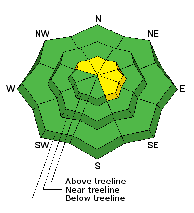
bottom line Overall, the avalanche danger is generally LOW but unstable snow may exist on isolated terrain features in upper elevation, steep and radical terrain, that has a NW-N-SE aspect.
|
 |
special announcement This mid-week advisory provides general snow, avalanche and mountain weather information. More detailed information will be posted on Friday, March 18. Please help guide our discussions of website maintenance, upgrades or possible changes in coming years. Take this brief survey. As a way of saying thanks we'll be raffling a free avalanche class and other free stuff like hats, beanies, water bottles, etc |
 |
current conditions A storm system on Monday left trace amounts of snow and produced strong west southwest winds. Expect to find a mix of wind and sun damaged snow and possibly isolated, shallow wind slabs in upper elevation terrain. Winds, temperature and humidity on Pre-Laurel Peak New snow totals, temperature and humidity in Gold Basin Total snow depth and temperature at Geyser Pass Trailhead
|
 |
recent activity
|
| type | aspect/elevation | characteristics |
|---|

|
|
LIKELIHOOD
 LIKELY
UNLIKELY
SIZE
 LARGE
SMALL
TREND
 INCREASING DANGER
SAME
DECREASING DANGER
|
|
description
Generally safe avalanche conditions exist in the La Sal Mountains. But as we like to remind you, low danger doesn't mean no danger. In fact, the definition of low danger says to watch for unstable snow on isolated terrain features. Potential areas of unstable snow still include: Wind Slabs: You may encounter isolated wind slabs on the lee sides of ridge crests and terrain features in upper elevation, wind exposed terrain, primarily on slopes that have a NW-N-SE aspect. Mostly shallow, they could possibly knock you off your feet and sweep you over a cliff in areas of steep and more radical terrain. Persistent Slab: Much more the exception than the rule, there are still areas of steep, rocky, and more radical terrain where it may be possible to trigger a persistent slab where the underlying snow is shallow, weak and faceted. Continue to practice safe travel techniques and approach areas of steep, rocky, radical terrain with caution. .
|
 |
weather Wednesday Mostly sunny, with a high near 34. Breezy, with a northwest wind 20 to 25 mph, with gusts as high as 40 mph. Wednesday Night Partly cloudy, with a low around 21. Blustery, with a west northwest wind 15 to 20 mph, with gusts as high as 35 mph. Thursday Sunny, with a high near 36. Breezy, with a west northwest wind 15 to 20 mph. Thursday Night Partly cloudy, with a low around 17. Friday Sunny, with a high near 27. Friday Night Mostly clear, with a low around 17. Saturday Sunny, with a high near 32. Saturday Night Mostly clear, with a low around 23. Sunday Sunny, with a high near 37.
|
| general announcements Road Conditions: The road is a mix of dirt at lower elevations that turns to mud as the day progresses. It is snowpacked higher up. To post an observation go here. You can view Moab observations here. You can also give me a call on my cell phone at 801-647-8896 To receive this advisory by email go here. This information does not apply to developed ski areas or highways where avalanche control is normally done. This advisory is from the U.S.D.A. Forest Service, which is solely responsible for its content. This advisory describes general avalanche conditions and local variations always exist. |


