| Please join us at the 23rd annual Black Diamond Fall Fundraiser Party Thursday Sept 15. Tickets are on sale now here, at the Black Diamond store & at REI. Special bonus raffle for online ticket purchasers! |
| Please join us at the 23rd annual Black Diamond Fall Fundraiser Party Thursday Sept 15. Tickets are on sale now here, at the Black Diamond store & at REI. Special bonus raffle for online ticket purchasers! |
| Advisory: Moab Area Mountains | Issued by Eric Trenbeath for Thursday - March 10, 2016 - 6:45am |
|---|

|
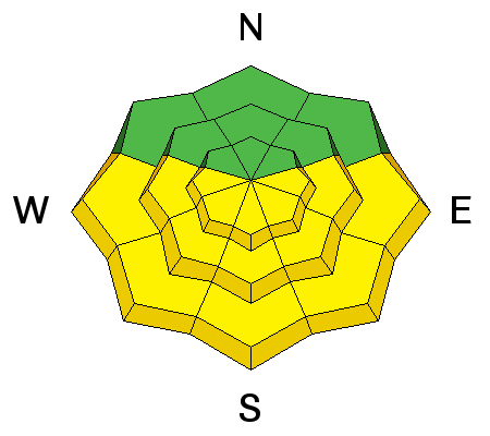
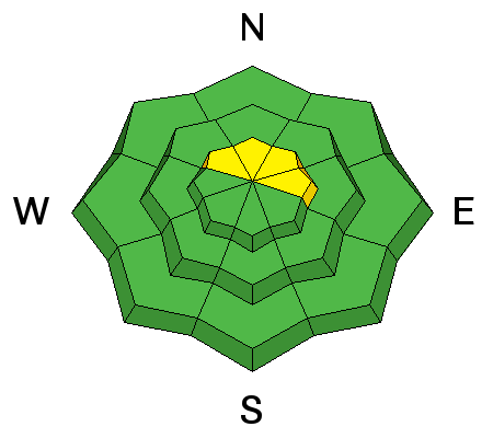
bottom line With daytime heating, the danger will rise to MODERATE on sun exposed slopes. Look for signs of instability such as roller balls or pinwheels, and sloppy wet snow. Get off of, and stay out from under sun exposed slopes when these signs are present. There remains a MODERATE avalanche danger in upper elevation, wind exposed terrain, primarily on slopes with a NW-N-E aspect where it is still possible to trigger a wind slab formed earlier in the week. Terrain choices are key - suspect slopes with steep convexities, and look for drifted snow on the lee sides of ridge crests and terrain features.
|
 |
special announcement
|
 |
current conditions Skies are clear this morning, ridgetop winds are averaging 10-15 mph from the NW, and temperatures are a seasonable cool at around 20 degrees at 10,000. Dry powder snow from the Sunday-Monday storm can still be found on sheltered, northerly aspects. Sunny slopes have been crusted over. Base depth in Gold Basin: 69" Winds, temperature and humidity on Pre-Laurel Peak New snow totals, temperature and humidity in Gold Basin Total snow depth and temperature at Geyser Pass Trailhead
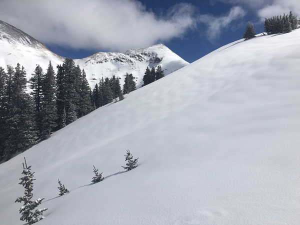
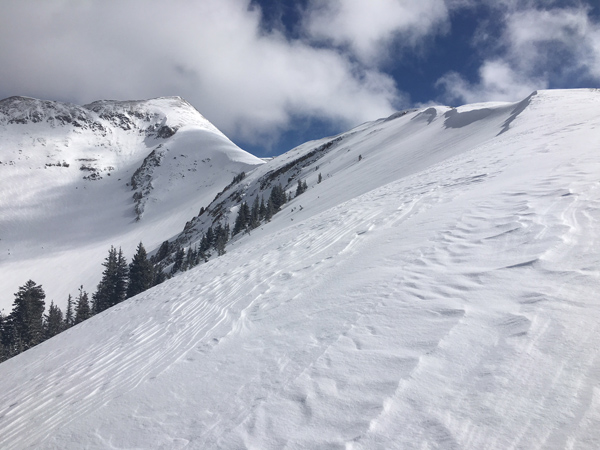
A new coat off snow has improved things greatly and good powder exists just below treeline or on more sheltered slopes above.
But go a little higher into more exposed terrain and it starts to look like this. |
 |
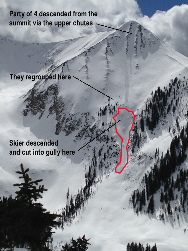
recent activity A skier triggered a slide in Gold Basin on the NE face of Tukno yesterday. He was caught and carried over rocks and sustained a leg injury. The culprit was reported to be a wind slab between 12-16" deep on the lee side of a very steep, convex break over. I'll get in there today to have a look around and will post a full report tomorrow.
This photo was taken from across the basin by a member of a party who would come to play a key role in the rescue.
|
| type | aspect/elevation | characteristics |
|---|

|
|
LIKELIHOOD
 LIKELY
UNLIKELY
SIZE
 LARGE
SMALL
TREND
 INCREASING DANGER
SAME
DECREASING DANGER
|
|
description
With daytime heating, the danger will increase for wet slide activity on sun exposed slopes. Look for signs of instability such as roller balls or pinwheels, and sloppy wet snow. Get off of and stay out from under sun exposed slopes when these signs are present.
.
|
| type | aspect/elevation | characteristics |
|---|

|
|
LIKELIHOOD
 LIKELY
UNLIKELY
SIZE
 LARGE
SMALL
TREND
 INCREASING DANGER
SAME
DECREASING DANGER
|
|
description
Though isolated, yesterday's incident demonstrates that dangerous wind slabs formed during the Sunday-Monday storm are still lurking about. You will most likely encounter wind slabs in more extreme, upper elevation, wind exposed terrain, on slopes that have a NW-N-E aspect. Terrain features are a key element. Suspect steep convexities and blind break-overs, as well as the lee sides of ridge crests, gully walls and sub-ridges. Cracking in the snow surface is becoming less evident, but look for smooth rounded pillows of wind drifted snow in these areas. |
 |
weather Temperatures are going to soar into the mid 40's today around 10,000' and it's going to be even warmer tomorrow. A storm tracking south into Arizona and New Mexico will bring clouds and a chance of snow to our area by Saturday afternoon. Today Sunny, with a high near 45. North northwest wind 5 to 10 mph becoming south southwest in the afternoon. Tonight Mostly clear, with a low around 30. South wind 10 to 15 mph. Friday Sunny, with a high near 49. South wind around 15 mph. Friday Night Partly cloudy, with a low around 31. Breezy, with a south southwest wind 15 to 20 mph. Saturday A 30 percent chance of snow, mainly after 11am. Partly sunny, with a high near 44. South southwest wind 10 to 15 mph becoming west in the afternoon. Saturday Night A 10 percent chance of snow before 11pm. Partly cloudy, with a low around 26. Sunday A 10 percent chance of snow after 11am. Mostly sunny, with a high near 43. |
| general announcements Road Conditions: The road is a mix of dirt at lower elevations that turns to mud as the day progresses. It is snowpacked higher up. To post an observation go here. You can view Moab observations here. You can also give me a call on my cell phone at 801-647-8896 To receive this advisory by email go here. This information does not apply to developed ski areas or highways where avalanche control is normally done. This advisory is from the U.S.D.A. Forest Service, which is solely responsible for its content. This advisory describes general avalanche conditions and local variations always exist. |