| Please join us at the 23rd annual Black Diamond Fall Fundraiser Party Thursday Sept 15. Tickets are on sale now here, at the Black Diamond store & at REI. Special bonus raffle for online ticket purchasers! |
| Please join us at the 23rd annual Black Diamond Fall Fundraiser Party Thursday Sept 15. Tickets are on sale now here, at the Black Diamond store & at REI. Special bonus raffle for online ticket purchasers! |
| Advisory: Moab Area Mountains | Issued by Eric Trenbeath for Saturday - March 5, 2016 - 7:05am |
|---|

|
bottom line The avalanche danger is generally LOW but remember that low danger doesn't mean no danger. Continue to exercise caution in areas of steep, rocky, more radical terrain. As the day heats up, be alert to signs of wet instability on sun exposed slopes such as roller balls, pinwheels, or sloppy wet snow. Stay off of and out from under steep slopes when these signs are present.
|
 |
special announcement
|
 |
current conditions
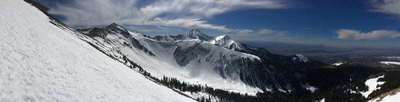
It's going to be a warm, windy, and mostly sunny day in the mountains. Yesterday, my partner Reed Kennard and I went poking around on the southwest face of Mount Mellenthin in search of corn. Enroute we found the usual mixed bag of spring like conditions, and also verified the need for glop stopper to keep snow from sticking to the bottom of your skins. We did indeed find good corn, but the strong sun and warm temperatures definitely made things sloppy by early afternoon. Today will be a little different as we did not get much of a freeze last night. Pre Laurel is coming in at 28 degrees this morning, but Gold Basin is at 35, and it's a scorching 40 degrees at the Geyser Pass trailhead. You'll need to be early, and fairly high today to find a supportable surface. Southwest winds have really ramped up as well and are currrently in the 30-40 mph range. Travel in the mountains is fast and easy, but many surfaces are very slick and hard, and slides for life are a very real possibilty. An Ice axe and crampons, or at least a whippet comes in handy on some of the steeper ascents in alpine terrain. Winds, temperature and humidity on Pre-Laurel Peak New snow totals, temperature and humidity in Gold Basin Total snow depth and temperature at Geyser Pass Trailhead |
 |
recent activity
|
| type | aspect/elevation | characteristics |
|---|

|
|
LIKELIHOOD
 LIKELY
UNLIKELY
SIZE
 LARGE
SMALL
TREND
 INCREASING DANGER
SAME
DECREASING DANGER
|
|
description
The avalanche danger is generally low right now, but low danger doesn't mean no danger and you should always maintain avalanche awareness and practice safe travel techniques in avalanche terrain. Loose Wet Slides: As the day heats up be alert to signs of wet instability such as rollerballs or pinwheels, and stay off of and out form under steep slopes when these signs are present.
|
 |
weather Today will be another mostly sunny and warm day in the mountains. High clouds will stream into the area, and southwest winds will be on the increase ahead of an approaching Pacific storm system that will begin to deliver snow sometime on Sunday. Colder air will add to the mix on Monday when we should see the greatest precipitation. Things dry out a bit mid week with a return to a moist pattern by Friday. Today Partly sunny, with a high near 35. Breezy, with a south southwest wind 15 to 20 mph, with gusts as high as 30 mph. Tonight A 20 percent chance of snow showers after midnight. Mostly cloudy, with a low around 27. Breezy, with a southwest wind 15 to 25 mph, with gusts as high as 40 mph. Sunday Snow showers. Some thunder is also possible. High near 31. Breezy, with a south southwest wind 20 to 25 mph, with gusts as high as 45 mph. Chance of precipitation is 80%. New snow accumulation of 2 to 4 inches possible. Sunday Night Snow showers. Some thunder is also possible. Low around 16. Windy, with a west southwest wind 25 to 30 mph, with gusts as high as 55 mph. Chance of precipitation is 90%. New snow accumulation of 3 to 5 inches possible. Monday Snow showers. High near 25. Breezy, with a northwest wind 15 to 20 mph. Chance of precipitation is 80%. |
| general announcements Road Conditions: The new snow has been packed in and in some places has already melted off down to the dirt. Grooming: Trails have not been groomed recently. To post an observation go here. You can view Moab observations here. You can also give me a call on my cell phone at 801-647-8896 To receive this advisory by email go here. This information does not apply to developed ski areas or highways where avalanche control is normally done. This advisory is from the U.S.D.A. Forest Service, which is solely responsible for its content. This advisory describes general avalanche conditions and local variations always exist. |