| Please join us at the 23rd annual Black Diamond Fall Fundraiser Party Thursday Sept 15. Tickets are on sale now here, at the Black Diamond store & at REI. Special bonus raffle for online ticket purchasers! |
| Please join us at the 23rd annual Black Diamond Fall Fundraiser Party Thursday Sept 15. Tickets are on sale now here, at the Black Diamond store & at REI. Special bonus raffle for online ticket purchasers! |
| Advisory: Moab Area Mountains | Issued by Eric Trenbeath for Tuesday - February 23, 2016 - 7:26am |
|---|


|
bottom line There is a MODERATE avalanche danger in upper elevation, wind exposed terrain both for loose dry avalanches, as well as recently deposited wind slabs on the lee sides of ridge crests and terrain features. At mid and lower elevations the avalanche danger is generally LOW.
|
 |
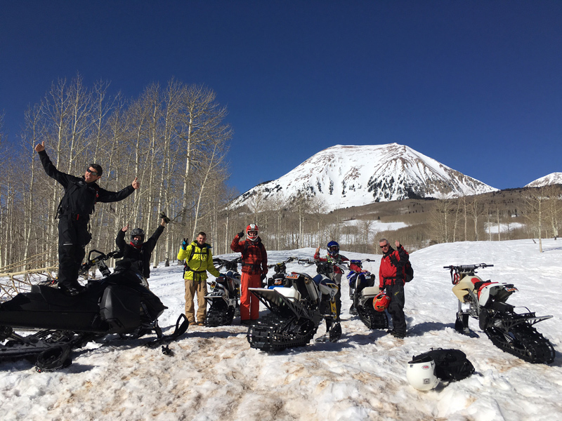
special announcement Hats off to Moab Powersports for stepping up and getting their snowbike riders educated about avalanches. These fellas just completed a 101 course with a nighttime classroom session and a day in the field. Good job guys!
|
 |
current conditions Wait, what is that? Fresh snow! The mountains picked up a surpise 6" last night starting around 8:00 p.m. This will certainly improve things, but you will need to seek out areas where the underlying snow surface is smooth for the best conditions. Lower angle slopes will also help cushion the blow on top of the old, hard, and sometimes featured surface. Overnight winds have been in the 10-20 mph range from the northeast, but at 7:00 this morning they rose into the mid 20's with a gust to 33. Winter temps have returned and it's currently 8 degrees on Pre Laurel Peak and 15 at the Geyser Pass trailhead. Winds, temperature and humidity on Pre-Laurel Peak New snow totals, temperature and humidity in Gold Basin Total snow depth and temperature at Geyser Pass Trailhead |
 |
recent activity
|
| type | aspect/elevation | characteristics |
|---|

|

|
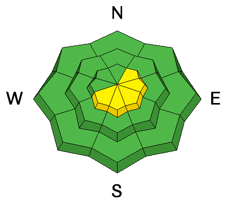
LIKELIHOOD
 LIKELY
UNLIKELY
SIZE
 LARGE
SMALL
TREND
 INCREASING DANGER
SAME
DECREASING DANGER
|
|
description
The new snow will easily slide off the variety of slick, hard surfaces out there so be alert to loose snow sluffs on steep slopes, primarily in upper elevation terrain. Mostly manageable, and not large enough to bury you, a loose snow slide could possibly sweep you off your feet and take you for a ride over a cliff or push you into a tree.
|
| type | aspect/elevation | characteristics |
|---|

|
|
LIKELIHOOD
LIKELY
UNLIKELY
SIZE
LARGE
SMALL
TREND
 INCREASING DANGER
SAME
DECREASING DANGER
|
|
description
Winds were pretty well behaved during the storm but they have been on the increase since 7:00 a.m. Expect to find sensitive new wind drifts developing on the lee sides of ridge crests and terrain features in upper elevation, wind exposed terrain. Mostly shallow and manageable, you can test for new wind slabs with a slope cut before dropping into terrain steeper than about 35 degrees.
|
 |
weather That's all folks. Skies will begin clearing today becoming partly sunny by afternoon. By Wednesday a ridge of high pressure builds and sets in for the long term. Today Snow likely, mainly before 7am. Partly sunny, with a high near 26. North northeast wind 10 to 15 mph, with gusts as high as 25 mph. Chance of precipitation is 60%. Total daytime snow accumulation of 1 to 2 inches possible. Tonight A 10 percent chance of snow before 8pm. Mostly clear, with a low around 14. Northeast wind 5 to 10 mph becoming light and variable. Wednesday Sunny, with a high near 33. West southwest wind around 5 mph. Wednesday Night Partly cloudy, with a low around 24. Northwest wind around 10 mph. Thursday Sunny, with a high near 35. North wind 10 to 15 mph. Thursday Night Mostly clear, with a low around 24. Friday Sunny, with a high near 36. Friday Night Mostly clear, with a low around 26. |
| general announcements Road Conditions: Expect a few inches of new snow on top off frozen dirt. Grooming: Grooming equipment has been brought down for maintenance. Next grooming will likely be on Friday. To post an observation go here. You can view Moab observations here. You can also give me a call on my cell phone at 801-647-8896 To receive this advisory by email go here. This information does not apply to developed ski areas or highways where avalanche control is normally done. This advisory is from the U.S.D.A. Forest Service, which is solely responsible for its content. This advisory describes general avalanche conditions and local variations always exist. |