| Please join us at the 23rd annual Black Diamond Fall Fundraiser Party Thursday Sept 15. Tickets are on sale now here, at the Black Diamond store & at REI. Special bonus raffle for online ticket purchasers! |
| Please join us at the 23rd annual Black Diamond Fall Fundraiser Party Thursday Sept 15. Tickets are on sale now here, at the Black Diamond store & at REI. Special bonus raffle for online ticket purchasers! |
| Advisory: Moab Area Mountains | Issued by Eric Trenbeath for Tuesday - January 26, 2016 - 6:22am |
|---|

|
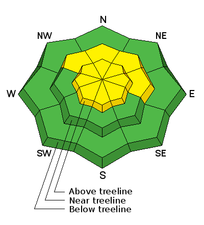
bottom line Today the avalanche danger is MODERATE on all aspects steeper than 35 degrees in upper elevation, wind exposed terrain where you can detect recent deposits of wind drifted snow. Look for tell tale signs such as smooth rounded drifts, and cracking in the snow surface, and be wary of the lee sides of gully walls, subridges, and other terrain features. There also remains an isolated, or MODERATE avalanche danger on steep slopes facing NW-E-SE where it may be possible to trigger a lingering, persistent slab avalanche. Careful slope and snowpack analysis is recommended before venturing into this kind of terrain. Elsewhere, the avalanche danger is generally LOW.
|
 |
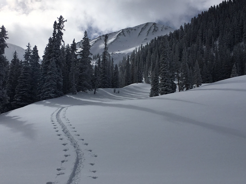
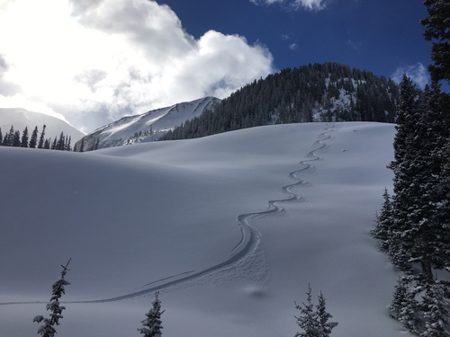
current conditions Today will be a glorious day in the mountains. 5-7" of light fluffy powder fell late Sunday afternoon, and conditions below tree line are excellent. Above tree line, winds during the storm blew just enough to prevent the new snow from covering up the old scoured surface. Winds were light most of the day yesterday, and temperatures remained cold, only getting up to around 20 degrees at 10,000', and barely over 10 at 11,000' under broken skies. In other words, we should be able to get another day of good riding on sun exposed slopes. Ridge top winds overnight were northeasterly and mostly light, though a few gusts around midnight reached up into the mid 20's. They are currently averaging 5-10 mph with gusts in the teens. It's 9 degrees at the Geyser Pass Trailhead and 5 on Pre Laurel Peak. Base depth in gold Basin: 65" Winds, temperature and humidity on Pre-Laurel Peak New snow totals, temperature and humidity in Gold Basin Total snow depth and temperature at Geyser Pass Trailhead
Winter wonderland!
.
|
 |
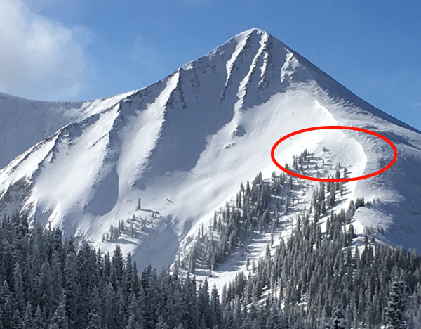
recent activity I observed a few small sluffs and some isolated, shallow storm slab pockets yesterday as well as this pocket pictured below on the east facing shoulder of Tukno.
This is a classic fetch for westerly winds. It looked like a small cornice had developed before breaking off and initiating a shallow sluff that ran for about 150'.
|
| type | aspect/elevation | characteristics |
|---|

|
|
LIKELIHOOD
 LIKELY
UNLIKELY
SIZE
 LARGE
SMALL
TREND
 INCREASING DANGER
SAME
DECREASING DANGER
|
|
description
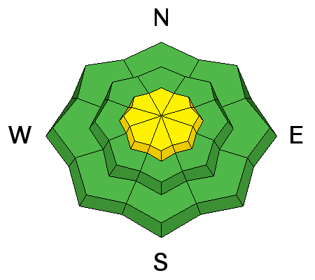
I didn't find any sensitive wind slabs out there yesterday, nor did I observe any cracking, but there were fresh drifts of snow 12-18" deep on all aspects right around treeline and just below. These drifts were soft, and lacking in cohesion, but as I looked further down slope, tell tale pillows perched on steep convexities kept me from venturing into more radical terrain. In the right spot, you may be able to trigger a slab with enough cohesion to take you for a ride, or worse still, step down into a buried weak layer causing a deeper and more dangerous persistent slab avalanche. Carefully inspect terrain steeper than 35 degrees and be leery of convexities that lure you further down slope.
Avoid steep, convex terrain such as this where loading has occurred further down slope.
|
| type | aspect/elevation | characteristics |
|---|

|
|
LIKELIHOOD
 LIKELY
UNLIKELY
SIZE
 LARGE
SMALL
TREND
 INCREASING DANGER
SAME
DECREASING DANGER
|
|
description
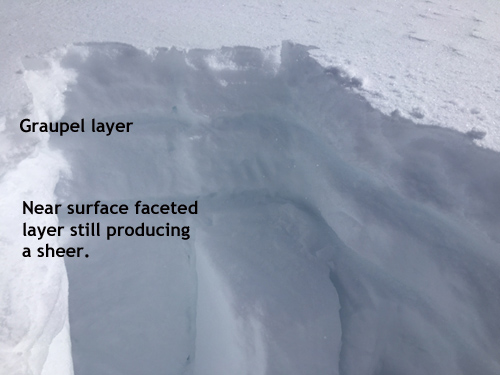
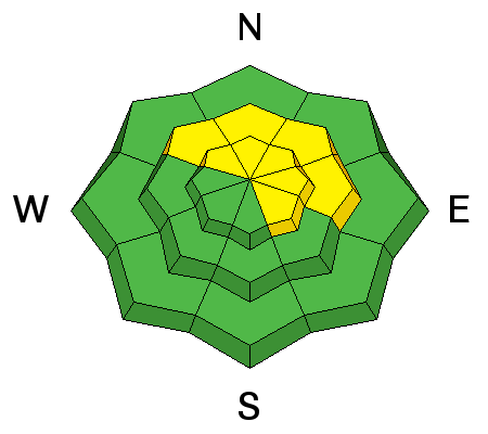
We've still got a few persistent weak layers in the upper portion of our snowpack. These layers aren't particularly reactive, but it may still be possible to trigger an avalanche in steeper, more radical terrain, primarily on slopes that face NW-E-SE right around treeline and above. We also have some areas of shallower snowpack, either on slopes that avalanched during the Christmas cycle, or in starting zones that have been repeatedly wind scoured and re-filled. In these areas, weak sugary, faceted snow near the ground may still pose a threat if an overlying slab exists. The only way to really know what is going on is to dig. And this practice should still be applied before venturing on to slopes steeper than about 35 degrees.
Photo illustrates persistent weak layers in the snowpack.
|
 |
weather A high pressure ridge will keep us under clear and sunny skies through Friday. Today Patchy fog before 10am. Otherwise, sunny, with a high near 17. Wind chill values as low as -20. North wind around 15 mph. Tonight Mostly clear, with a low around 9. North wind around 15 mph, with gusts as high as 25 mph. Wednesday Sunny, with a high near 25. Northwest wind 10 to 15 mph. Wednesday Night Partly cloudy, with a low around 13. Northwest wind 5 to 10 mph. Thursday Sunny, with a high near 27. Northwest wind 5 to 10 mph. Thursday Night Mostly clear, with a low around 16. Friday Mostly sunny, with a high near 29. |
| general announcements Road Conditions: The road has not been plowed but been many vehicles made it up yesterday and packed the new snow down. The Forest Service is working with Grand and San Juan Counties to develop a plowing solution. Please bare with us until it can be worked out. Grooming: The groomers will be up and at it today, so expect trails to be in good shape by this afternoon. Thanks for sending in your observations. You can view Moab observations here. To post an observation go here. To receive this advisory by email go here. This information does not apply to developed ski areas or highways where avalanche control is normally done. This advisory is from the U.S.D.A. Forest Service, which is solely responsible for its content. This advisory describes general avalanche conditions and local variations always exist. |