| Please join us at the 23rd annual Black Diamond Fall Fundraiser Party Thursday Sept 15. Tickets are on sale now here, at the Black Diamond store & at REI. Special bonus raffle for online ticket purchasers! |
| Please join us at the 23rd annual Black Diamond Fall Fundraiser Party Thursday Sept 15. Tickets are on sale now here, at the Black Diamond store & at REI. Special bonus raffle for online ticket purchasers! |
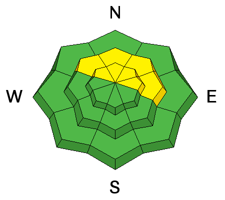
| Advisory: Moab Area Mountains | Issued by Eric Trenbeath for Sunday - January 17, 2016 - 6:39am |
|---|

|
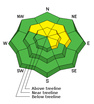
bottom line Today there is a MODERATE danger for triggering shallow wind slabs along the lee sides of upper elevation ridge crests and terrain features, primarily on slopes with a NW-E-SE aspect. Out of the wind zone, the avalanche danger is generally LOW, though a very isolated or MODERATE danger still exists on steep, northerly facing aspects for triggering a deep slab avalanche. This danger exists primarily in areas of rocky, more radical terrain, and in areas with a thin snowpack.
|
 |
special announcement
Thanks to everyone who participated in our 101 class yesterday making it a huge success. Avalanche awareness starts here! And a big shout out to past La Sal forecaster Max Forgensi for coming over from Colorado and helping out with this course. This allowed us to bump our enrollment up to 17. Thanks Max! And thanks also to La Sal observer and certified AIARE instructor Evan Clapper. Couldn't have done it without you guys! |
 |
current conditions Trace amounts of snow fell in the mountains last night, and winds yesterday began to have their way with the snow surface in exposed locations. Overnight winds averaged 20-25 mph with gusts to 30 mph from the WNW. They've backed off slightly this morning and are blowing in the 12-25 mph range. It's 21 degrees at the Geyser Pass Trailhead and 12 on Pre Laurel Peak. Base depth in gold Basin: 60" Winds, temperature and humidity on Pre-Laurel Peak New snow totals, temperature and humidity in Gold Basin Total snow depth and temperature at Geyser Pass Trailhead
|
 |
recent activity What started as a small point release yesterday, high on the NE face of Tukno, managed to entrain enough snow over it's 1000' run to deposit a significant pile of soft debris in Tele Gold.
|
| type | aspect/elevation | characteristics |
|---|

|
|
LIKELIHOOD
 LIKELY
UNLIKELY
SIZE
 LARGE
SMALL
TREND
 INCREASING DANGER
SAME
DECREASING DANGER
|
|
description
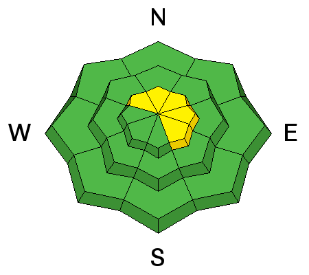
Winds continue to move snow around in exposed, upper elevation locations, resulting in the formation of shallow wind slabs on the lee sides of ridge crests and terrain features. Though mostly shallow and not posing too much of a problem, a triggered wind slab in steep terrain could knock you off your feet and carry you over a cliff or push you into trees. Be alert to smooth rounded pockets of wind drifted snow. primarily on slopes steeper than 35 degrees that face NW-N-SE. Additionally, some of these slabs are forming over several inches of loose, surface snow that is poorly bonded with the underlying, much stronger snowpack. Though not currently reactive, time will tell whether or not this will become our next persistent weak layer.
|
| type | aspect/elevation | characteristics |
|---|

|
|
LIKELIHOOD
 LIKELY
UNLIKELY
SIZE
 LARGE
SMALL
TREND
 INCREASING DANGER
SAME
DECREASING DANGER
|
|
description
The chances of triggering a deep slab avalanche are becoming increasingly unlikely. Areas where you may still encounter this problem are on steep, northerly facing aspects, particularly in areas of rocky, more radical terrain, and in areas with a shallower snowpack. It's all about trigger points and finding the sweet spot now. Avoid thinner areas around rock outcroppings, tree islands, and along the edges of slopes.
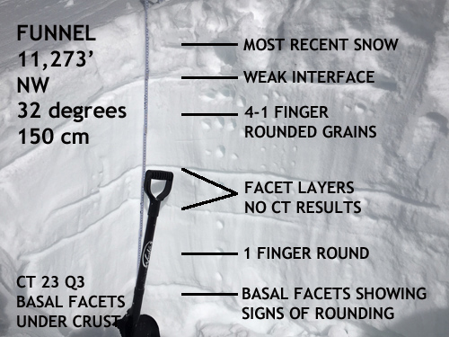
This snowpit dug in the Funnel is fairly representative of what I've been finding on other north facing slopes above 11,000'. Mid level facet layers are becoming non-reactive to stability tests, and the snowpack above the basal facets is very strong, and more than 4' deep. |
 |
weather The weak disturbance that has been affecting areas to our north will exit the region today. A brief ridge of high pressure will move through on Monday, followed by the return of a series of fast moving, short wave troughs on a northwesterly flow. This pattern extends through Wednesday bringing us mostly unsettled weather with moderate winds, and possibly a few inches of snow. Sunday A 30 percent chance of snow, mainly before 10am. Partly sunny, with a high near 24. Northwest wind 10 to 15 mph. Tonight Mostly cloudy, with a low around 17. West northwest wind 5 to 10 mph. M.L.King Day A 20 percent chance of snow after 11am. Mostly cloudy, with a high near 28. Southwest wind 10 to 15 mph. Monday Night Snow likely. Areas of blowing snow after 11pm. Cloudy, with a low around 15. Breezy, with a west southwest wind 15 to 20 mph, with gusts as high as 30 mph. Chance of precipitation is 70%. New snow accumulation of 1 to 3 inches possible. Tuesday A 40 percent chance of snow, mainly before 11am. Areas of blowing snow before 11am. Partly sunny, with a high near 22. Northwest wind around 15 mph, with gusts as high as 25 mph. Tuesday Night Snow likely, mainly after 11pm. Areas of blowing snow after 11pm. Mostly cloudy, with a low around 15. Breezy. Chance of precipitation is 60%. Wednesday Snow likely, mainly before 11am. Areas of blowing snow after 11am. Mostly cloudy, with a high near 20. Chance of precipitation is 60%. Wednesday Night A slight chance of snow before 11pm. Areas of blowing snow before 11pm. Partly cloudy, with a low around 11. Blustery. Thursday Mostly sunny, with a high near 24. |
| general announcements Grooming: All trails were groomed yesterday, but they will be coated with a few inches of fresh snow this morning. Thanks for sending in your observations. You can view Moab observations here. To post an observation go here. To receive this advisory by email go here. This information does not apply to developed ski areas or highways where avalanche control is normally done. This advisory is from the U.S.D.A. Forest Service, which is solely responsible for its content. This advisory describes general avalanche conditions and local variations always exist. |