| Please join us at the 23rd annual Black Diamond Fall Fundraiser Party Thursday Sept 15. Tickets are on sale now here, at the Black Diamond store & at REI. Special bonus raffle for online ticket purchasers! |
| Please join us at the 23rd annual Black Diamond Fall Fundraiser Party Thursday Sept 15. Tickets are on sale now here, at the Black Diamond store & at REI. Special bonus raffle for online ticket purchasers! |
| Advisory: Moab Area Mountains | Issued by Eric Trenbeath for Friday - January 1, 2016 - 6:36am |
|---|


|
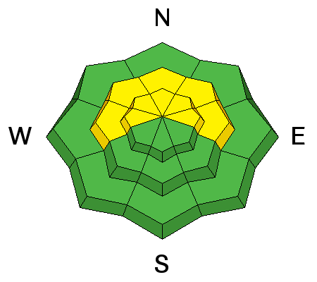
bottom line The avalanche danger remains MODERATE on mid and upper elevation slopes steeper than 35 degrees that face W-N-E, with the greatest danger on NE aspects. Though difficult to trigger, an avalanche triggered in these areas would be deep and dangerous. Careful slope and snowpack evaluation is necessary before venturing into this kind of terrain. There are plenty of good riding options on lower angle slopes.
|
 |
special announcement Grand County made it up the road with the grader on Wednesday. Up to 6" of light powder fell on the road Wednesday night, but many cars made it up to Geyser Pass Trailhead yesterday. |
 |
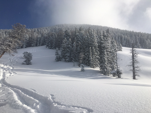
current conditions It's truly as good as it gets out there. Even during my 10 years at Alta I haven't seen better conditions. 8-10" of very low density, light powder snow fell without wind on Wednesday night. Underneath is a lovely cushion of settled snow from the nearly 3' we received last week. Above tree line, a hard, wind scoured surface can be felt beneath the new snow, but below treeline, conditions are nothing short of sublime. Ridge top winds remain light this morning, in the single digits from the southeast. Temperatures are cold and inverted. It's 8 degrees on Pre Laurel Peak, and 3 at Geyser Pass Trailhead.
Winds, temperature and humidity on Pre-Laurel Peak New snow totals, temperature and humidity in Gold Basin Total snow depth and temperature at Geyser Pass Trailhead
|
 |
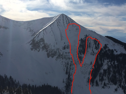
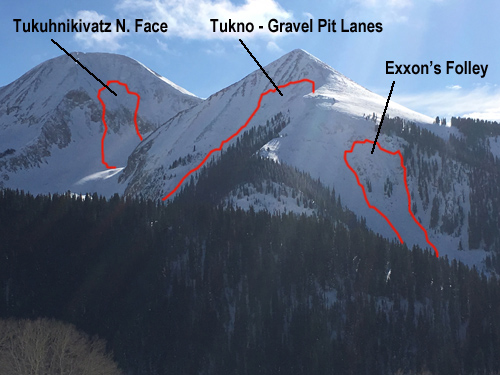
recent activity No new avalanche activity has been observed since last weekend but if you haven't been following the report, it's worth noting these slides from last weekend that ran on persistent weak layers with one running full depth to the ground. Yesterday, my partners and I headed over to the Corkscrew Glades to check out these slides observed by Ed Grote earlier in the week. Snow from the Christmas storm, and the wind event of Dec 26, produced natural avalanche activity on all aspects. Slides on slopes facing W-S-SE were pockety in nature, and consisted of newly deposited wind slabs averaging 2- 3' deep. More significant slides occurred on north and east facing aspects including a full depth release more than 6' deep on the east face of Tukno. For a complete list of observed avalanches go here.
East face of Tukno. Slide on left ran full depth to the ground whereas slide on the right ran down to a mid level persistent weakness.
View shows two other slides in Gold Basin. Only Gravel Pit Lanes ran full depth.
|
| type | aspect/elevation | characteristics |
|---|

|
|
LIKELIHOOD
 LIKELY
UNLIKELY
SIZE
 LARGE
SMALL
TREND
 INCREASING DANGER
SAME
DECREASING DANGER
|
|
description
Persistent slab problems vary, and avalanches are becoming harder to trigger, but the consequences remain high. It is possible to trigger a persistent slab avalanche to the ground though it is more likely that one would be triggered on a mid-level faceted layer. The danger exists on slopes steeper than 35 degrees that face W-N-E with the highest danger on NE aspects. Careful slope evaluation and determining whether or not a weak layer is present is essential before venturing into this terrain.
This buried faceted layer was responsible for the slides in Corksrew Glades. |
 |
weather Look for mostly sunny skies and cold temperatures this morning. Clouds will begin to stream in this afternoon bringing a slight chance of snow flurries. A brief ridge builds over the weekend before a trough dominated pattern moves in on Monday and we will see an extended period of wet and snowy weather. A 10 percent chance of snow after 4pm. Increasing clouds, with a high near 11. Wind chill values as low as -15. South wind 10 to 15 mph. Tonight A 20 percent chance of snow. Mostly cloudy, with a low around 4. Wind chill values as low as -15. South wind around 15 mph. Saturday A 10 percent chance of snow before 11am. Partly sunny, with a high near 16. Wind chill values as low as -15. South wind 10 to 15 mph. Saturday Night Mostly cloudy, with a low around 11. South wind 10 to 15 mph. Sunday Partly sunny, with a high near 21. West southwest wind 10 to 15 mph. Sunday Night Mostly cloudy, with a low around 14. |
| general announcements
Thanks for sending in your observations. You can view Moab observations here. To post an observation go here. To receive this advisory by email go here. This information does not apply to developed ski areas or highways where avalanche control is normally done. This advisory is from the U.S.D.A. Forest Service, which is solely responsible for its content. This advisory describes general avalanche conditions and local variations always exist. |