| Please join us at the 23rd annual Black Diamond Fall Fundraiser Party Thursday Sept 15. Tickets are on sale now here, at the Black Diamond store & at REI. Special bonus raffle for online ticket purchasers! |
| Please join us at the 23rd annual Black Diamond Fall Fundraiser Party Thursday Sept 15. Tickets are on sale now here, at the Black Diamond store & at REI. Special bonus raffle for online ticket purchasers! |
| Advisory: Moab Area Mountains | Issued by Eric Trenbeath for Tuesday - December 22, 2015 - 6:37am |
|---|


|
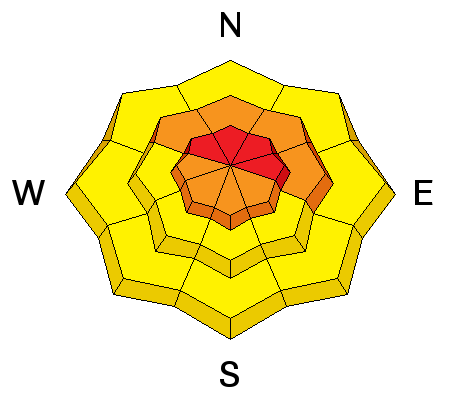
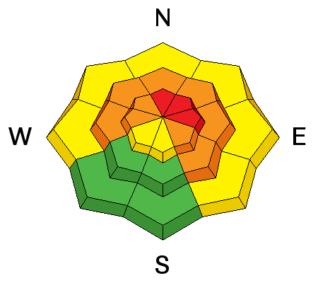
bottom line Expect the danger to rise to HIGH today as new snow and wind combine to create unstable avalanche conditions, particularly on upper mid to upper elevation northerly facing aspects. Stay off of and out from under steep slopes today. Backcountry travel is not recommended for folks who do not have excellent route finding and avalanche awareness skills.
|
 |
avalanche watch THE FOREST SERVICE UTAH AVALANCHE CENTER IN MOAB UTAH HAS ISSUED A BACKCOUNTRY AVALANCHE WATCH. * TIMING…IN EFFECT FROM 6 PM MST MONDAY EVENING TO 6 AM MST WEDNESDAY MORNING * AFFECTED AREA…FOR THE MOUNTAINS OF SOUTHEASTERN UTAH INCLUDING THE LA SAL...ABAJO MOUNTAINS * AVALANCHE DANGER…THE AVALANCHE DANGER FOR THE WARNING AREA WILL RISE TONIGHT AND WILL LIKELY BE HIGH BY TUESDAY. * REASON…HEAVY SNOW COMBINED WITH WIND WILL LIKELY CREATE WIDESPREAD AREAS OF UNSTABLE SNOW. BOTH HUMAN TRIGGERED AND NATURAL AVALANCHES ARE ANTICIPATED TO BE LIKELY ON SLOPES STEEPER THAN ABOUT 30 DEGREES.
|
 |
special avalanche bulletin I issued an Avalanche Watch for the mountains of southeastern Utah at 6:00 pm last night to run through 6:00 am Wednesday morning. Timing of the storm, and less than forecasted snow totals overnight are preventing me from upgrading to an Avalanche Warning this morning. Today it will be essential for backcountry travelers to be alert to a potential rapid increase in the avalanche danger due to accumulating new snow and strong winds. |
 |
special announcement
|
 |
current conditions Forecasted snow totals came in on the low end last night with the Gold Basin study plot reporting 5" of new snow top of Sunday's 5" . Up to a foot of snow is in the forecast today with accompanying moderate to strong SW winds. In short, it should be quite blizzard like up there today. Overnight, winds along ridge tops have averaged 20 mph with gusts into the low 50's from the SW. It's currently 25 degrees at the Geyser Pass Trailhead and 16 on Pre Laurel Peak. Thanks to Matt and Dave for sending in these observations from yesterday. Winds, temperature and humidity on Pre-Laurel Peak New snow totals, temperature and humidity in Gold Basin Total snow depth and temperature at Geyser Pass Trailhead
|
 |
recent activity
|
| type | aspect/elevation | characteristics |
|---|

|
|
LIKELIHOOD
 LIKELY
UNLIKELY
SIZE
 LARGE
SMALL
TREND
 INCREASING DANGER
SAME
DECREASING DANGER
|
|
description
Strong winds combined with lots of snow available for transport will result in widespread areas of deep drifting snow, especially in upper elevation, wind exposed terrain. Stay off of and out from under steep slopes today, and in particular those that have a N-NE-E aspect. Triggered wind slabs could be in excess of 2' deep and have the potential to step down into buried weak layers causing an even deeper and more dangerous persistent slab avalanche.
|
| type | aspect/elevation | characteristics |
|---|

|
|
LIKELIHOOD
LIKELY
UNLIKELY
SIZE
 LARGE
SMALL
TREND
INCREASING DANGER
SAME
DECREASING DANGER
|
|
description
Weight is accumulating on top of our buried, persistent weak layers. With strong winds and heavy snow in the forecast, this could be just what we need to tip the balance and trigger a round of persistent slab avalanches. This problem is most acute on slopes facing NW-N-E starting from a few hundred feet below tree line and extending into the upper elevations. Stay off of and out from under steep slopes with these aspects today.
|
 |
weather A powerful storm system will affect our area today into early Wednesday morning. The initial trough has good jet support and will move through our area this morning producing areas of heavy snow. Another weaker trough will move through late this afternoon bringing an other period of intense snowfall before sunset. Snow showers should linger into Wednesday morning. Another system on a SW flow is on track to affect our area starting late Christmas Eve and into Christmas Day. Today Snow. High near 19. West southwest wind around 15 mph, with gusts as high as 30 mph. Chance of precipitation is 100%. Total daytime snow accumulation of 9 to 13 inches possible. Tonight Snow. Low around 9. Blustery, with a west northwest wind 15 to 20 mph, with gusts as high as 30 mph. Chance of precipitation is 90%. New snow accumulation of 2 to 4 inches possible. Wednesday Snow likely. Mostly cloudy, with a high near 13. Wind chill values as low as -10. Blustery, with a west northwest wind 20 to 25 mph, with gusts as high as 35 mph. Chance of precipitation is 60%. New snow accumulation of 2 to 4 inches possible. Wednesday Night A 30 percent chance of snow, mainly before 11pm. Areas of blowing snow. Mostly cloudy, with a low around 3. Wind chill values as low as -15. Blustery, with a west northwest wind 15 to 20 mph. Thursday A 50 percent chance of snow, mainly after 11am. Cloudy, with a high near 13. South southwest wind around 15 mph. Thursday Night Snow likely. Areas of blowing snow after 11pm. Cloudy, with a low around 10. Breezy. Chance of precipitation is 70%. Christmas Day Snow likely. Areas of blowing snow. Cloudy, with a high near 14. Breezy. Chance of precipitation is 70%. |
| general announcements Expect to find several inches of new snow and drifted snow on the road to the Geyser Pass trailhead this morning. Thanks for sending in your observations. You can view Moab observations here. To post an observation go here. To receive this advisory by email go here. This information does not apply to developed ski areas or highways where avalanche control is normally done. This advisory is from the U.S.D.A. Forest Service, which is solely responsible for its content. This advisory describes general avalanche conditions and local variations always exist. |


