| Please join us at the 23rd annual Black Diamond Fall Fundraiser Party Thursday Sept 15. Tickets are on sale now here, at the Black Diamond store & at REI. Special bonus raffle for online ticket purchasers! |
| Please join us at the 23rd annual Black Diamond Fall Fundraiser Party Thursday Sept 15. Tickets are on sale now here, at the Black Diamond store & at REI. Special bonus raffle for online ticket purchasers! |
| Advisory: Moab Area Mountains | Issued by Eric Trenbeath for Sunday - December 20, 2015 - 6:55am |
|---|


|
bottom line Today there is a MODERATE danger in wind exposed terrain on slopes steeper than 35 degrees that face NW-E-SE where recently deposited wind slabs have formed over the past 24 hours. There also remains a MODERATE but tricky avalanche danger on slopes steeper than 35 degrees that face NW-N-E due to the presence of buried persistent weak layers in the snowpack. These areas warrant extra caution for awhile due to the very real potential for triggering a dangerous persistent slab avalanche.
|
 |
special announcement
|
 |
current conditions The story is the wind. Since about 2:00 pm yesterday SSW winds have averaged 30 mph with gusts to near 50 mph. Above tree line, and in exposed terrain below, the snow surface is pretty worked over, and south facing aspects have developed a sun crust. In sheltered areas however, conditions remain quite good with the storm of last week settled out to about 14" of powder. It's currently 32 degrees at the Geyser Pass Trailhead and 21 in gold Basin. Base depth in Gold Basin: 42" Base depth at Geyser Pass Trailhead: 30" Yesterday wasn't the best day to fix a weather station, but in the midst of 35 mph gusts, and through the invaluable assistance of Ed Grote, the Pre Laurel Peak weather station is back on line reporting hourly wind speed and direction. We got Gold Basin sorted out as well so watch it for new snow totals this week. Winds, temperature and humidity on Pre-Laurel Peak New snow totals, temperature and humidity in Gold Basin Total snow depth and temperature at Geyser Pass Trailhead
|
 |
recent activity
|
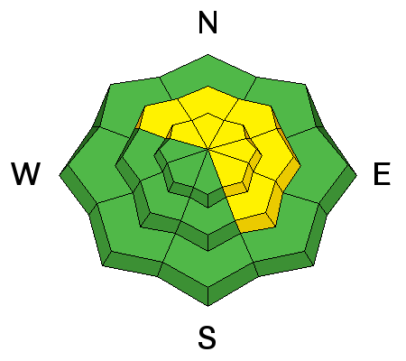
| type | aspect/elevation | characteristics |
|---|

|
|
LIKELIHOOD
 LIKELY
UNLIKELY
SIZE
 LARGE
SMALL
TREND
 INCREASING DANGER
SAME
DECREASING DANGER
|
|
description
In my travels yesterday I observed new, stiff wind slab development along upper elevation ridge crests on slopes that faced NW-NE-E-SE. Hard and stubborn, I couldn't even get them to crack out but they are definitely there. Additionally, snow was being transported further down slope where I suspect you can find fresh drifts with more sensitivity. Suspect areas that have a characteristic, smooth rounded appearance, and be wary of the lee sides of terrain features such as gullies and sub ridges. Areas beneath cliff bands, where eddying wind currents have allowed snow to be deposited are especially suspect. Triggered wind slabs also have the potential for stepping down into buried weak layers causing a larger and more dangerous persistent slab avalanche.
|
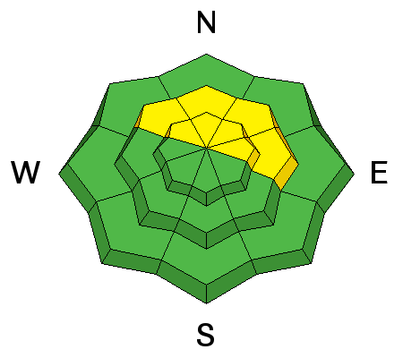
| type | aspect/elevation | characteristics |
|---|

|
|
LIKELIHOOD
 LIKELY
UNLIKELY
SIZE
 LARGE
SMALL
TREND
 INCREASING DANGER
SAME
DECREASING DANGER
|
|
description
The snow from earlier this week has settled into place, and gone are existing signs of instability. However, layers of weak faceted snow exist in the snowpack, and we've moved into a tricky phase where it might just take the additional weight of a skier or rider to trigger a dangerous persistent slab avalanche. This problem is most acute on slopes facing NW-N-E starting from a few hundred feet below tree line and extending into the upper elevations. Slopes steeper than 35 degrees are best avoided in these areas. For more details on this problem check out this great observation from Dave Garcia. Thanks Dave! |
 |
weather An unsettled weather pattern is on tap for the week with our first chance at some snow looking like Monday into Tuesday. A series of systems will then move through the area with one on Christmas Day looking like the biggest hitter. Today A 40 percent chance of snow, mainly after 11am. Mostly cloudy, with a high near 18. Breezy, with a west southwest wind 15 to 20 mph. Tonight A 30 percent chance of snow, mainly before 11pm. Areas of fog after 8pm. Otherwise, mostly cloudy, with a low around 12. Southwest wind around 15 mph, with gusts as high as 25 mph. Monday A 50 percent chance of snow, mainly after 11am. Areas of fog before 11am. Otherwise, mostly cloudy, with a high near 23. West southwest wind 10 to 15 mph. New snow accumulation of less than a half inch possible. Monday Night Snow likely, mainly after 11pm. Cloudy, with a low around 14. Breezy, with a west southwest wind 15 to 20 mph increasing to 20 to 25 mph after midnight. Winds could gust as high as 40 mph. Chance of precipitation is 60%. New snow accumulation of 1 to 3 inches possible. |
| general announcements San Juan county did an excellent job plowing and the road is open. Travis will be up grooming today. Thanks for sending in your observations. You can view Moab observations here. To post an observation go here. To receive this advisory by email go here. This information does not apply to developed ski areas or highways where avalanche control is normally done. This advisory is from the U.S.D.A. Forest Service, which is solely responsible for its content. This advisory describes general avalanche conditions and local variations always exist. |


