| Please join us at the 23rd annual Black Diamond Fall Fundraiser Party Thursday Sept 15. Tickets are on sale now here, at the Black Diamond store & at REI. Special bonus raffle for online ticket purchasers! |
| Please join us at the 23rd annual Black Diamond Fall Fundraiser Party Thursday Sept 15. Tickets are on sale now here, at the Black Diamond store & at REI. Special bonus raffle for online ticket purchasers! |
| Advisory: Moab Area Mountains | Issued by Eric Trenbeath for Thursday - December 17, 2015 - 6:31am |
|---|

|
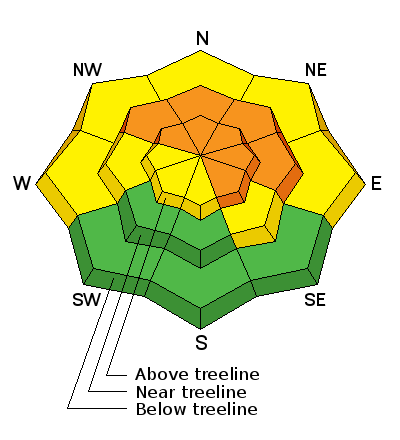
bottom line Right around tree line and above there remains a CONSIDERABLE avalanche danger both for recently deposited wind slabs, as well as deeper persistent slab avalanches. Slopes steeper than 35 degrees should be avoided particularly those with a NW-E-SE aspect. Below tree line the avalanche danger is MODERATE but tricky, and careful slope evaluation is still necessary before venturing in to steep terrain.
|
 |
special announcement The Utah Avalanche Center-Moab will be presenting a free Know Before You Go avalanche awareness presentation at the Grand County Library tonight December 17 at 6:30 p.m. Call the Manti-La Sal National Forest office at 435-259-7155 for more information.
|
 |
current conditions Two feet of light, fluffy powder graced the mountains on Monday, and by all accounts from yesterday, conditions remain excellent. Westerly winds in the upper elevations have begun to affect the snow surface a bit in exposed areas and a thin crust has formed on due south aspects. But in all other areas it's powder! For more details check out this great observation from Brett Sutteer. Thanks Brett! Overnight ridge top winds have been on the increase from the WNW, averaging 15 mph with gusts into the low 30's. Winds are going to make an already cold day feel colder causing a wind chill value of -15. It is currently 10 degrees at the Geyser Pass Trailhead and 0 on Pre Laurel Peak. Winds, temperature and humidity on Pre-Laurel Peak New snow totals, temperature and humidity in Gold Basin Total snow depth and temperature at Geyser Pass Trailhead
|
 |
recent activity I received a few reports of two natural avalanches. Beyond noting that they were about two feet deep and confined to the new snow, I don't have any further dimensions. One occurred on the E face of Tukno, observers left of Gravel Pit Lanes, and the other on Noriega's Face, a north facing, 40 degree, convex slope that drops into Brumley Creek.
|
| type | aspect/elevation | characteristics |
|---|

|
|
LIKELIHOOD
 LIKELY
UNLIKELY
SIZE
 LARGE
SMALL
TREND
 INCREASING DANGER
SAME
DECREASING DANGER
|
|
description
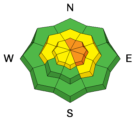
Wind slabs have developed in upper elevation wind exposed terrain. With plenty of snow available for transport, and with winds on the increase, watch for the danger to rise. A triggered wind slab also has the danger of stepping down into buried weak layers causing a larger and more dangerous persistent slab avalanche. Though most likely found on slopes facing N-E-SE, shifting winds over the past few days may have created pockets on other aspects where cross-loading as had an effect. Look for recent deposits of wind drifted snow on the lee sides of ridge crests and terrain features, and be alert to signs of instability of cracking or collapsing. |
| type | aspect/elevation | characteristics |
|---|

|
|
LIKELIHOOD
LIKELY
UNLIKELY
SIZE
 LARGE
SMALL
TREND
 INCREASING DANGER
SAME
DECREASING DANGER
|
|
description
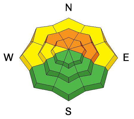
The new snow has settled into place without directly affecting the underlying weak layers. We have however, begun to add straw to the proverbial camel's back and the additional weight of a skier or rider may be just enough to tip the scales and cause a deep and dangerous persistent slab avalanche. It's time to stay off of steep, northerly facing aspects right around tree line and above for a little while. |
 |
weather Today Mostly sunny, with a high near 19. Wind chill values as low as -15. Blustery, with a north northwest wind 15 to 20 mph decreasing to 5 to 10 mph in the afternoon. Tonight Mostly cloudy, with a low around 10. West wind 5 to 10 mph. Friday Mostly sunny, with a high near 28. Northwest wind 5 to 10 mph becoming south southwest in the afternoon. Friday Night Partly cloudy, with a low around 16. South southwest wind 5 to 15 mph. Saturday Mostly sunny, with a high near 32. South southwest wind 10 to 15 mph. Saturday Night A 20 percent chance of snow after 11pm. Mostly cloudy, with a low around 19. Sunday A 30 percent chance of snow. Partly sunny, with a high near 26. |
| general announcements San Juan county did an excellent job plowing and the road is open. Thanks for sending in your observations. You can view Moab observations here. To post an observation go here. To receive this advisory by email go here. This information does not apply to developed ski areas or highways where avalanche control is normally done. This advisory is from the U.S.D.A. Forest Service, which is solely responsible for its content. This advisory describes general avalanche conditions and local variations always exist. |


