| Please join us at the 23rd annual Black Diamond Fall Fundraiser Party Thursday Sept 15. Tickets are on sale now here, at the Black Diamond store & at REI. Special bonus raffle for online ticket purchasers! |
| Please join us at the 23rd annual Black Diamond Fall Fundraiser Party Thursday Sept 15. Tickets are on sale now here, at the Black Diamond store & at REI. Special bonus raffle for online ticket purchasers! |
| Advisory: Moab Area Mountains | Issued by Eric Trenbeath for Saturday - December 12, 2015 - 6:27am |
|---|

|
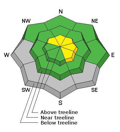
bottom line Today look for a rising MODERATE danger for triggering a recently deposited wind slab in exposed terrain that faces N-NE-E. Mostly isolated, slabs will form on the lee sides of terrain features and further down the slope than usual. You may also be able to trigger an older, stiff slab in these same areas. There is also the possibility that a triggered wind slab could step further down into older, weak, sugary snow causing a persistent slab avalanche. Suspect slopes with more radical terrain and distinctive terrain features such as gullies, rock bands, or convex break overs. Elsewhere, the avalanche danger is generally LOW.
|
 |
special announcement Today, UAC-Moab sponsor Moab Gear Trader, and Moab Cliffs and Canyons will be sponsoring a free beacon clinic at the new Talking Mountain Yurt in Gold Basin at 1:00 p.m. Folks can either meet at the Yurt or at the Geyser Pass Trailhead at noon. For more information call Evan from Moab Cliffs and Canyons 435-260-7066, or Marshall at Moab Gear Trader 435-355-0333. And, the Utah Avalanche Center-Moab will be presenting a free Know Before You Go avalanche awareness presentation at the Grand County Library on Thursday, December 17 at 6:30 p.m. Call the Manti-La Sal National Forest office at 435-259-7155 fro more information. |
 |
current conditions The mountains picked up about 3" of snow overnight, and if nothing else, it will feel like winter up there today. It is currently 14 degrees in Gold Basin and 24 at the Geyser Pass Trailhead. Ridge top winds are light this morning, in the single digits with gusts into the teens from the WSW, but expect them to be on the rise today, up into the 20-30 mph range with gusts as high as 40 mph from the West. The underlying old snow surface was pretty worked over from the ravages of wind and sun. Today you will need to stick to sheltered terrain below tree line, or areas where you know the underlying surface was smooth to get the most out of the new snow. The new snow will also serve to hide some of the obstacles that were beginning to show such as stumps and dead fall, so be alert to these dangers just below the surface. Base depth in Gold Basin: 30" Base depth at Geyser Pass Trailhead: 20" Winds, temperature and humidity on Pre-Laurel Peak New snow totals, temperature and humidity in Gold Basin Total snow depth and temperature at Geyser Pass Trailhead
|
| type | aspect/elevation | characteristics |
|---|

|
|
LIKELIHOOD
 LIKELY
UNLIKELY
SIZE
 LARGE
SMALL
TREND
 INCREASING DANGER
SAME
DECREASING DANGER
|
|
description
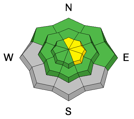
Strong westerly winds over the past several days have formed isolated, stiff, shallow wind slabs on N-NE-E aspects in upper elevation, wind exposed terrain. The new snow today will hide these slabs, and as winds pick up, begin to form new ones. Though mostly shallow, these slabs could knock you off your feet and take you for a ride over cliffs or rocks. And in some cases, it may be possible to trigger a wind slab and have it step down into buried, weak sugary snow causing a persistent slab avalanche. With many of the ridge tops scoured down to the rocks, the danger will be located further down the slope than usual. Look for areas of deposition beneath rock bands and on the lee sides of terrain features such as gully walls or sub ridges. |
| type | aspect/elevation | characteristics |
|---|

|
|
LIKELIHOOD
LIKELY
UNLIKELY
SIZE
 LARGE
SMALL
TREND
 INCREASING DANGER
SAME
DECREASING DANGER
|
|
description
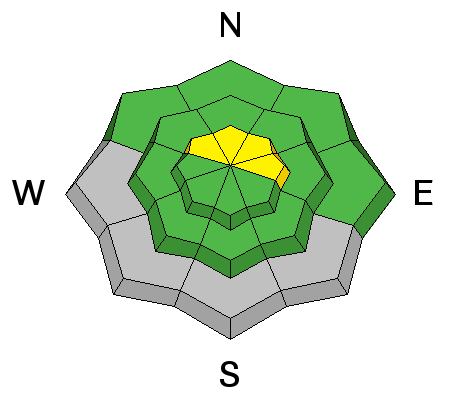
The new snow hasn't provided enough of a load to reactivate persistent weaknesses in the snowpack, but it may be possible for a triggered wind slab avalanche step down into these buried weak layers. The most likely areas for encountering this problem are on steep, northerly aspects at and above tree line. Slopes with defined terrain features such as gullies, rock bands, or steep, convex break overs warrant extra caution.
|
 |
weather We may see some lingering snow showers this morning as the last of this storm moves eastward. High temperatures at 10,000' will be in the mid 20's and winds will be on the increase from the west. Sunday looks to be partly sunny as a brief ridge builds ahead of the next similar storm system that will move into our area on Monday. Today
Snow, mainly before 1pm. High near 25. Windy, with a west wind 5 to 10 mph becoming north 20 to 30 mph. Winds could gust as high as 45 mph. Chance of precipitation is 80%. Total daytime snow accumulation of 1 to 3 inches possible. Tonight A 20 percent chance of snow before 10pm. Partly cloudy, with a low around 8. Wind chill values as low as -10. Windy, with a north wind 20 to 30 mph becoming east after midnight. Winds could gust as high as 45 mph. Sunday A 20 percent chance of snow after 2pm. Partly sunny, with a high near 25. Wind chill values as low as -10. Blustery, with a northeast wind 15 to 20 mph becoming west in the afternoon. Sunday Night Mostly cloudy, with a low around 14. Windy, with a southwest wind 15 to 20 mph increasing to 25 to 30 mph after midnight. Winds could gust as high as 45 mph. Monday Snow. High near 19. Windy, with a south southwest wind 25 to 35 mph becoming west northwest 15 to 25 mph in the afternoon. Winds could gust as high as 45 mph. Chance of precipitation is 80%. |
| general announcements The Road to the Geyser Pass Trailhead will not be plowed this morning so expect to find a couple inches of snow on top of packed snow and ice. Grooming equipment is ready and grooming should begin this week! Thanks for sending in your observations. You can view Moab observations here. To post an observation go here. To receive this advisory by email go here. This information does not apply to developed ski areas or highways where avalanche control is normally done. This advisory is from the U.S.D.A. Forest Service, which is solely responsible for its content. This advisory describes general avalanche conditions and local variations always exist. |


