25th Annual Black Diamond Fall Fundraising Party
Thursday, September 13; 6:00-10:00 PM; Black Diamond Parking Lot
25th Annual Black Diamond Fall Fundraising Party
Thursday, September 13; 6:00-10:00 PM; Black Diamond Parking Lot
| Advisory: Logan Area Mountains | Issued by Toby Weed for Friday - March 2, 2018 - 6:39am |
|---|

|
bottom line There's CONSIDERABLE danger in the backcountry. Dangerous avalanche conditions exist on drifted slopes, and increasingly heavy snow and strong southwest wind will cause the danger to rise further today. Triggered wind slab and persistent slab avalanches will become likely at upper and mid elevations, with natural avalanches possible.
|
 |
avalanche watch THE FOREST SERVICE UTAH AVALANCHE CENTER IN SALT LAKE CITY HAS ISSUED A BACKCOUNTRY AVALANCHE WATCH. * TIMING...IN EFFECT FROM 6 AM MST THIS MORNING TO 6 AM MST SATURDAY. * AFFECTED AREA...FOR THE MOUNTAINS OF NORTHERN AND CENTRAL UTAH INCLUDING THE WASATCH RANGE, BEAR RIVER RANGE, UINTA MOUNTAINS, AND THE MANTI-SKYLINE AND WASATCH PLATEAU. * AVALANCHE DANGER...THE AVALANCHE DANGER FOR THE WARNING AREA IS CONSIDERABLE AND IS EXPECTED TO RISE TO HIGH * REASON/IMPACTS...STRONG WINDS AND HEAVY SNOWFALL WILL LIKELY CREATE DANGEROUS AVALANCHE CONDITIONS CONTINUING INTO MONDAY. BOTH HUMAN TRIGGERED AND NATURAL AVALANCHES ARE LIKELY. STAY OFF OF AND OUT FROM UNDERNEATH SLOPES STEEPER THAN 30 DEGREES. BACKCOUNTRY TRAVELERS SHOULD CONSULT WWW.UTAHAVALANCHECENTER.ORG OR CALL 1-888-999-4019 FOR MORE DETAILED INFORMATION. THIS WATCH DOES NOT APPLY TO SKI AREAS WHERE AVALANCHE HAZARD REDUCTION MEASURES ARE PERFORMED. $$ |
 |
special announcement Episode 6 of the UAC podcast "A Conversation with Tom Kimbrough, Hemingway of the Wasatch" is live. We explore ideas about lifetime exposure to risk and what role Buddhism has played in his life as a climber, skier, and soon-to-be octogenarian. We talk about what has changed over the years in snow science and the role of mentorship in the world of avalanche forecasting and other professions and pursuits. Check it out on ITunes, Stitcher, the UAC blog. |
 |
current conditions A major winter storm is on our doorstep, and we'll see increasingly heavy snow, strong south-southwest wind, and increasingly dangerous avalanche conditions in the mountains today.
|
 |
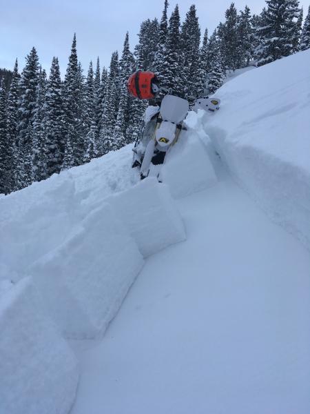
recent activity Two reports of avalanches observed Wednesday. Both likely failed on a persistent weak layer made up of a facet/crust combo from late Jan or early Feb.
|
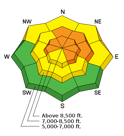
| type | aspect/elevation | characteristics |
|---|

|
|
LIKELIHOOD
 LIKELY
UNLIKELY
SIZE
 LARGE
SMALL
TREND
 INCREASING DANGER
SAME
DECREASING DANGER
|
|
description
Human triggered avalanches 2 to 3 feet-deep are possible in steep drifted terrain.
|
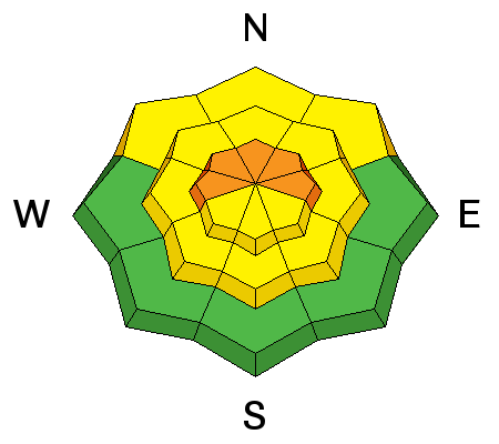
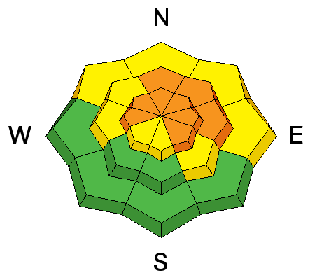
| type | aspect/elevation | characteristics |
|---|

|
|
LIKELIHOOD
 LIKELY
UNLIKELY
SIZE
 LARGE
SMALL
TREND
INCREASING DANGER
SAME
DECREASING DANGER
|
|
description
Areas with dangerous persistent slab avalanche conditions exist in drifted terrain at upper and mid elevations. Buried layers of weak faceted snow and rain-crusts from late January and early February are suspect. Human triggered avalanches up to around 3-feet-deep, stepping down into buried persistent weak layers are possible.
|
 |
weather The National Weather Service has issued a Winter Storm Warning in our area for the whole weekend.. Heavy snowfall, with around 2" total SWE is expected in the Logan Zone starting today and lasting through tomorrow night. Strong south-southwest winds today will decrease this evening and become more westerly, and snowfall will continue, likely intensifying a bit tomorrow...
|
| general announcements We have discount lift tickets for Alta, Snowbird, Brighton, Solitude, Snowbasin,and Beaver Mountain. Details and order information here. All proceeds from your purchase go towards paying for avalanche forecasting and education. Episode 5 of the UAC podcast To Hell in a Heartbeat - A Conversation With Tom Diegel and Matt Clevenger About the 12.26.08 Full Burial on Little Water is live. This podcast talks with Matt and Tom about their experience and the massive success of the To Hell in a Heartbeat video which has been viewed almost 3M times. Check it out on ITunes, Stitcher, the UAC blog, or wherever you get your podcasts. The UAC Marketplace is online. The holiday auction is closed, but our online marketplace still has deals on skis, packs, airbag packs, beacons, snowshoes, soft goods and much more. The UAC has new support programs with Outdoor Research and Darn Tough. Support the UAC through your daily shopping. When you shop at Smith's, or online at Outdoor Research, REI, Backcountry.com, Darn Tough, Patagonia, NRS, Amazon, eBay a portion of your purchase will be donated to the FUAC. See our Donate Page for more details on how you can support the UAC when you shop. Benefit the Utah Avalanche Center when you buy or sell on eBay - set the Utah Avalanche Center as a favorite non-profit in your eBay account here and click on eBay gives when you buy or sell. You can choose to have your seller fees donated to the UAC, which doesn't cost you a penny Check it out on ITunes, Stitcher, the UAC blog, or wherever you get your podcasts. Now is a great time to practice companion rescue techniques with your backcountry partners. Here's our rescue practice video. EMAIL ADVISORY: If you would like to get the daily advisory by email you will need to subscribe here. Remember your information can save lives. If you see anything we should know about, please help us out by submitting snow and avalanche observations. You can also call us at 801-524-5304, email by clicking HERE, or include #utavy in your Instagram. This advisory is from the U.S.D.A. Forest Service, which is solely responsible for its content. This advisory describes general avalanche conditions and local variations always occur. |


 - Version 2.jpg)