25th Annual Black Diamond Fall Fundraising Party
Thursday, September 13; 6:00-10:00 PM; Black Diamond Parking Lot
25th Annual Black Diamond Fall Fundraising Party
Thursday, September 13; 6:00-10:00 PM; Black Diamond Parking Lot
| Advisory: Logan Area Mountains | Issued by Toby Weed for Tuesday - February 27, 2018 - 7:05am |
|---|

|
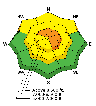
bottom line Dangerous avalanche conditions exist on drifted upper elevation slopes, and there are areas with CONSIDERABLE danger. You'll find excellent Utah powder riding and safer conditions in sheltered, lower angled, and lower elevation terrain.
|
 |
special announcement Remember your information can save lives. If you see anything we should know about, please help us out by submitting snow and avalanche observations. You can also call us at 801-524-5304, email by clicking HERE, or include #utavy in your Instagram. |
 |
current conditions You'll still be able to find stellar powder riding and mostly stable snow in sheltered terrain. Cold temperatures and clouds have kept the snow nice, but those dang westerly winds on Sunday and Monday jacked it and drifted it around in exposed terrain. A couple inches of light snow from yesterday and overnight will hide deep drifts and wind affected snow. You'll encounter satstrugi and wind-board crusts of varying thickness on windward slopes, and large, recently built cornices and deep drifts in lee terrain. Travel through avalanche terrain with caution and a heightened degree of situational awareness.
|
 |
recent activity Westerly wind over the weekend caused natural cornice fall and wind slab avalanche activity, and we have reports of a few intentionally triggered wind slabs in drifted terrain. Limited visibility in the past few day has prevented views of most upper elevation terrain. |
| type | aspect/elevation | characteristics |
|---|

|
|
LIKELIHOOD
 LIKELY
UNLIKELY
SIZE
 LARGE
SMALL
TREND
 INCREASING DANGER
SAME
DECREASING DANGER
|
|
description
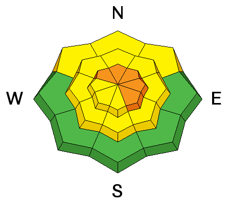
The light powder was easily picked up and drifted into lee slope avalanche starting zones. Wind slabs have perhaps become less sentitive since the drifting slowed yesterday, but human triggered avalanches up to about 2 feet-deep are likely in steep drifted terrain.
Thanks to Brian Smith for the wind slab video from 2/25.... |
| type | aspect/elevation | characteristics |
|---|

|
|
LIKELIHOOD
 LIKELY
UNLIKELY
SIZE
LARGE
SMALL
TREND
 INCREASING DANGER
SAME
DECREASING DANGER
|
|
description
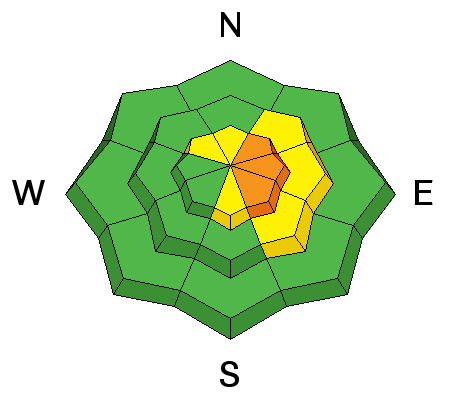
Avoid ridge-top cornices, which often break further back than expected and can trigger avalanches on drifted slopes below.
A natural cornice-fall triggered avalanche hit Tony Grove Lake with soft debris on Sunday, 2/25. |
| type | aspect/elevation | characteristics |
|---|

|
|
LIKELIHOOD
 LIKELY
UNLIKELY
SIZE
 LARGE
SMALL
TREND
INCREASING DANGER
SAME
DECREASING DANGER
|
|
description
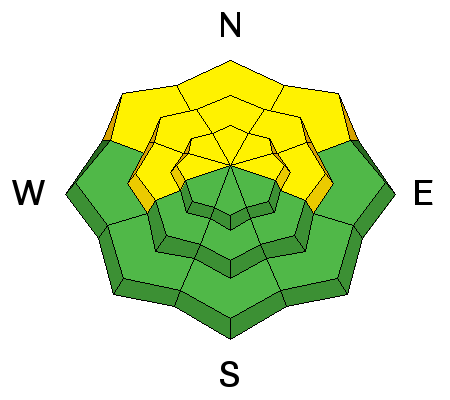
Areas with heightened persistent slab avalanche conditions exist in drifted terrain at upper and mid elevations. Buried layers of weak faceted snow and rain-crusts from late January and early February are suspect. Dangerous human triggered avalanches stepping down into buried persistent weak layers are possible.
|
 |
weather A low pressure system over California will spread light precipitation as far north as western and northern Utah this morning. Precipitation will spread into southern Utah tonight as the low pressure system tracks east across Arizona. A potentially significant winter storm will reach the Great Basin late in the week, with impacts lasting through the weekend.
|
| general announcements We have discount lift tickets for Alta, Snowbird, Brighton, Solitude, Snowbasin,and Beaver Mountain. Details and order information here. All proceeds from your purchase go towards paying for avalanche forecasting and education. Episode 5 of the UAC podcast To Hell in a Heartbeat - A Conversation With Tom Diegel and Matt Clevenger About the 12.26.08 Full Burial on Little Water is live. This podcast talks with Matt and Tom about their experience and the massive success of the To Hell in a Heartbeat video which has been viewed almost 3M times. Check it out on ITunes, Stitcher, the UAC blog, or wherever you get your podcasts. The UAC Marketplace is online. The holiday auction is closed, but our online marketplace still has deals on skis, packs, airbag packs, beacons, snowshoes, soft goods and much more. The UAC has new support programs with Outdoor Research and Darn Tough. Support the UAC through your daily shopping. When you shop at Smith's, or online at Outdoor Research, REI, Backcountry.com, Darn Tough, Patagonia, NRS, Amazon, eBay a portion of your purchase will be donated to the FUAC. See our Donate Page for more details on how you can support the UAC when you shop. Benefit the Utah Avalanche Center when you buy or sell on eBay - set the Utah Avalanche Center as a favorite non-profit in your eBay account here and click on eBay gives when you buy or sell. You can choose to have your seller fees donated to the UAC, which doesn't cost you a penny Check it out on ITunes, Stitcher, the UAC blog, or wherever you get your podcasts. Now is a great time to practice companion rescue techniques with your backcountry partners. Here's our rescue practice video. EMAIL ADVISORY: If you would like to get the daily advisory by email you will need to subscribe here. This advisory is from the U.S.D.A. Forest Service, which is solely responsible for its content. This advisory describes general avalanche conditions and local variations always occur. |


