25th Annual Black Diamond Fall Fundraising Party
Thursday, September 13; 6:00-10:00 PM; Black Diamond Parking Lot
25th Annual Black Diamond Fall Fundraising Party
Thursday, September 13; 6:00-10:00 PM; Black Diamond Parking Lot
| Advisory: Logan Area Mountains | Issued by Toby Weed for Saturday - February 24, 2018 - 6:14am |
|---|

|
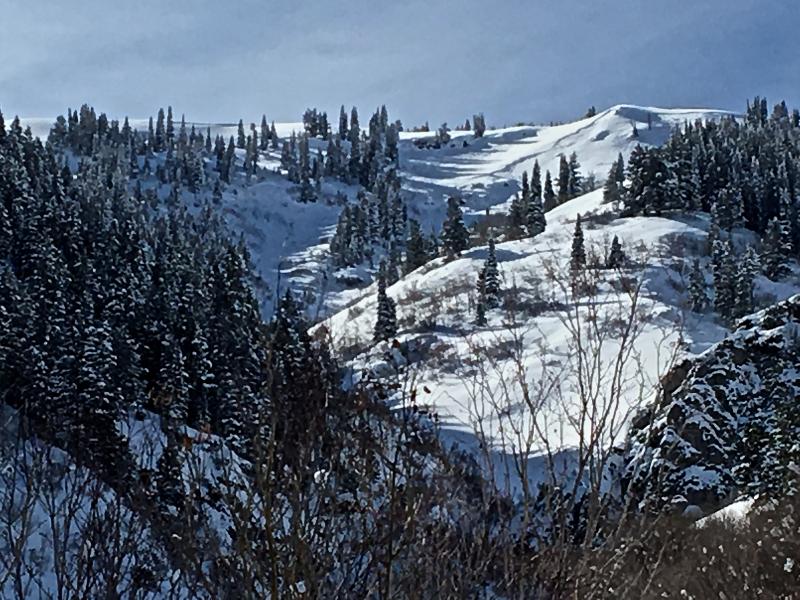
bottom line You'll find excellent powder conditions in the backcountry, but heightened avalanche conditions exist on drifted upper and mid elevation slopes. Human triggered persistent slab and wind slab avalanches are possible. Drifting from increasing southwest winds will cause the danger to rise and become more widespread today and tonight.
|
 |
special announcement We have discount lift tickets for Alta, Snowbird, Brighton, Solitude, Snowbasin,and Beaver Mountain. Details and order information here. All proceeds from your purchase go towards paying for avalanche forecasting and education. |
 |
current conditions Recent cold temperatures preserved the nice powder, and a few more inches of very light fresh snow fell yesterday. You'll find excellent powder riding and skiing in the backcountry, but human-triggered avalanches are possible. Heightened avalanche conditions exist on drifted upper and mid elevation slopes, and increasing southwest wind today will cause the danger to rise and become more widespread.
|
 |
recent activity
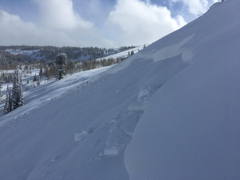
A very wide natural avalanche occurred in south Wood Camp late in the storm on 2/18 or 2/19.
|
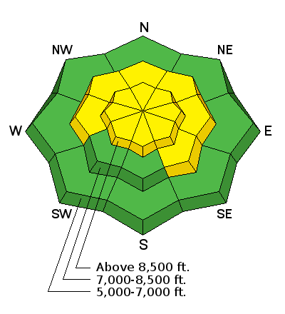
| type | aspect/elevation | characteristics |
|---|

|
|
LIKELIHOOD
 LIKELY
UNLIKELY
SIZE
 LARGE
SMALL
TREND
 INCREASING DANGER
SAME
DECREASING DANGER
|
|
description
Areas with heightened persistent slab avalanche conditions exist at upper and mid elevations, mainly in drifted terrain. Drifting from increasing westerly wind will cause the danger to rise further.
|
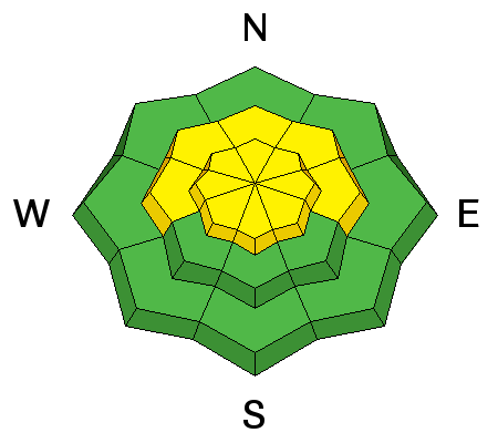
| type | aspect/elevation | characteristics |
|---|

|
|
LIKELIHOOD
LIKELY
UNLIKELY
SIZE
 LARGE
SMALL
TREND
INCREASING DANGER
SAME
DECREASING DANGER
|
|
description
The fresh powder is so light it won't take much wind to drift it in to avalanche starting zones. Sensitive human triggered wind slab avalanches are possible in drifted terrain. Increasing southwesterly wind will cause the danger of wind slab avalanches to increase and become more widespread during the day today.
|
 |
weather The active pattern across the western states will continue into the first half of next week. The next storm system will cross the area tonight through early Sunday. A new storm system will track south in California and have minimal impact on Utah midweek.
|
| general announcements Episode 5 of the UAC podcast To Hell in a Heartbeat - A Conversation With Tom Diegel and Matt Clevenger About the 12.26.08 Full Burial on Little Water is live. This podcast talks with Matt and Tom about their experience and the massive success of the To Hell in a Heartbeat video which has been viewed almost 3M times. Check it out on ITunes, Stitcher, the UAC blog, or wherever you get your podcasts. The UAC Marketplace is online. The holiday auction is closed, but our online marketplace still has deals on skis, packs, airbag packs, beacons, snowshoes, soft goods and much more. The UAC has new support programs with Outdoor Research and Darn Tough. Support the UAC through your daily shopping. When you shop at Smith's, or online at Outdoor Research, REI, Backcountry.com, Darn Tough, Patagonia, NRS, Amazon, eBay a portion of your purchase will be donated to the FUAC. See our Donate Page for more details on how you can support the UAC when you shop. Benefit the Utah Avalanche Center when you buy or sell on eBay - set the Utah Avalanche Center as a favorite non-profit in your eBay account here and click on eBay gives when you buy or sell. You can choose to have your seller fees donated to the UAC, which doesn't cost you a penny Check it out on ITunes, Stitcher, the UAC blog, or wherever you get your podcasts. Now is a great time to practice companion rescue techniques with your backcountry partners. Here's our rescue practice video. EMAIL ADVISORY: If you would like to get the daily advisory by email you will need to subscribe here. Remember your information can save lives. If you see anything we should know about, please help us out by submitting snow and avalanche observations. You can also call us at 801-524-5304, email by clicking HERE, or include #utavy in your Instagram. This advisory is from the U.S.D.A. Forest Service, which is solely responsible for its content. This advisory describes general avalanche conditions and local variations always occur. |