25th Annual Black Diamond Fall Fundraising Party
Thursday, September 13; 6:00-10:00 PM; Black Diamond Parking Lot
25th Annual Black Diamond Fall Fundraising Party
Thursday, September 13; 6:00-10:00 PM; Black Diamond Parking Lot
| Advisory: Logan Area Mountains | Issued by Toby Weed for Sunday - February 18, 2018 - 7:31am |
|---|

|
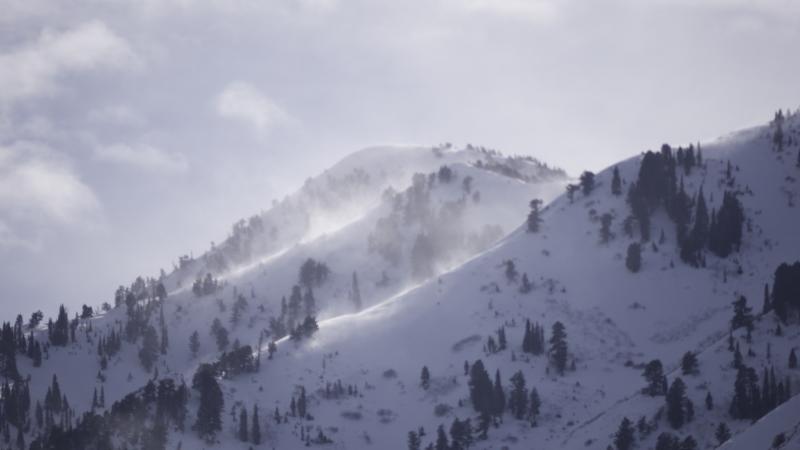
bottom line Heavy snowfall and drifting from strong westerly winds will cause blizzard conditions in the mountains, with rapidly rising CONSIDERABLE avalanche danger. Dangerous avalanche conditions exist and will develop in the backcountry today, with human triggered avalanches likely and naturals possible.
|
 |
avalanche watch THE FOREST SERVICE UTAH AVALANCHE CENTER IN SALT LAKE CITY HAS ISSUED A BACKCOUNTRY AVALANCHE WATCH. * TIMING...THROUGH 6 AM MST MONDAY. * AFFECTED AREA...FOR ALL THE MOUNTAINS OF NORTHERN AND CENTRAL UTAH. * AVALANCHE DANGER...THE AVALANCHE DANGER FOR THE WATCH AREA IS CONSIDERABLE AND EXPECTED TO RISE TO HIGH OVERNIGHT. * REASON/IMPACTS...STRONG WINDS TODAY WITH PERIODS OF HEAVY SNOW TONIGHT THROUGH TUESDAY WILL CREATE WIDESPREAD AREAS OF UNSTABLE SNOW. THE AVALANCHE DANGER WILL REMAIN ELEVATED THROUGH TUESDAY WITH BOTH HUMAN TRIGGERED AND NATURAL AVALANCHES BECOMING LIKELY. STAY OFF OF AND OUT FROM UNDER SLOPES GREATER THAN 30 DEGREES. BACKCOUNTRY TRAVELERS SHOULD CONSULT WWW.UTAHAVALANCHECENTER.ORG OR CALL 1-888-999-4019 FOR MORE DETAILED INFORMATION. THIS WATCH DOES NOT APPLY TO SKI AREAS WHERE AVALANCHE HAZARD REDUCTION MEASURES ARE PERFORMED. |
 |
current conditions The National Weather Service has issued a Winter Storm Warning for all the Utah mountains, and the slow moving storm will impact the Logan Zone first. It's already snowing pretty hard this morning at the UDOT Hwy 89 Summit Sheds and Beaver Mt. Expect blizzard conditions in the mountains at times today, with heavy snowfall and drifting from very strong and gusty west winds. The storm will create increasingly dangerous avalanche conditions today in the backcountry. The danger may rise to HIGH in some areas by evening, with natural avalanches becoming more likely as heavy snow accumulates and is drifted into avalanche starting zones.
|
 |
recent activity
|
| type | aspect/elevation | characteristics |
|---|

|
|
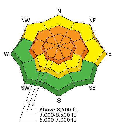
LIKELIHOOD
 LIKELY
UNLIKELY
SIZE
 LARGE
SMALL
TREND
 INCREASING DANGER
SAME
DECREASING DANGER
|
|
description
Continuing and increasing west wind will have plenty of soft snow to drift, will build up existing slabs, and create new drifts in lee slope deposition areas. Today's wind slabs will be stiffer, thicker, wider, run farther, and be less manageable than they were yesterday.
Westerly winds picked up yesterday afternoon, drifting snow at upper elevations in the Wellsville Range |
| type | aspect/elevation | characteristics |
|---|

|
|
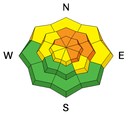
LIKELIHOOD
LIKELY
UNLIKELY
SIZE
LARGE
SMALL
TREND
INCREASING DANGER
SAME
DECREASING DANGER
|
description
|
 |
weather A cold upper trough will start to move into the Great Basin today, then move slowly south and east across the region through Tuesday. The coldest air of the season will accompany this storm, and remain over the area through much of the upcoming week.
|
| general announcements Episode 5 of the UAC podcast To Hell in a Heartbeat - A Conversation With Tom Diegel and Matt Clevenger About the 12.26.08 Full Burial on Little Water is live. This podcast talks with Matt and Tom about their experience and the massive success of the To Hell in a Heartbeat video which has been viewed almost 3M times. Check it out on ITunes, Stitcher, the UAC blog, or wherever you get your podcasts. We have discount lift tickets for Alta, Snowbird, Brighton, Solitude, Snowbasin,and Beaver Mountain. Details and order information here. All proceeds from your purchase go towards paying for avalanche forecasting and education. The UAC Marketplace is online. The holiday auction is closed, but our online marketplace still has deals on skis, packs, airbag packs, beacons, snowshoes, soft goods and much more. The UAC has new support programs with Outdoor Research and Darn Tough. Support the UAC through your daily shopping. When you shop at Smith's, or online at Outdoor Research, REI, Backcountry.com, Darn Tough, Patagonia, NRS, Amazon, eBay a portion of your purchase will be donated to the FUAC. See our Donate Page for more details on how you can support the UAC when you shop. Benefit the Utah Avalanche Center when you buy or sell on eBay - set the Utah Avalanche Center as a favorite non-profit in your eBay account here and click on eBay gives when you buy or sell. You can choose to have your seller fees donated to the UAC, which doesn't cost you a penny Check it out on ITunes, Stitcher, the UAC blog, or wherever you get your podcasts. Now is a great time to practice companion rescue techniques with your backcountry partners. Here's our rescue practice video. EMAIL ADVISORY: If you would like to get the daily advisory by email you will need to subscribe here. Remember your information can save lives. If you see anything we should know about, please help us out by submitting snow and avalanche observations. You can also call us at 801-524-5304, email by clicking HERE, or include #utavy in your Instagram. This advisory is from the U.S.D.A. Forest Service, which is solely responsible for its content. This advisory describes general avalanche conditions and local variations always occur. |