25th Annual Black Diamond Fall Fundraising Party
Thursday, September 13; 6:00-10:00 PM; Black Diamond Parking Lot
25th Annual Black Diamond Fall Fundraising Party
Thursday, September 13; 6:00-10:00 PM; Black Diamond Parking Lot
| Advisory: Logan Area Mountains | Issued by Toby Weed for Monday - February 12, 2018 - 7:16am |
|---|

|
bottom line Backcountry snow is stable in most areas, the danger is LOW, and avalanches are unlikely.
|
 |
special announcement We have discount lift tickets for Alta, Snowbird, Brighton, Solitude, Snowbasin,and Beaver Mountain. Details and order information here. All proceeds from these go towards paying for avalanche forecasting and education! |
 |
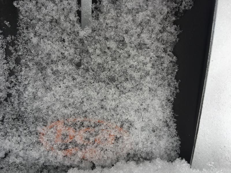
current conditions The Logan Zone has been left high and dry, while the mountains to our south have been blessed by small storms and little tastes of powder. Snow conditions are quite varied across the zone, with a brittle, translucent rain-crust on the snow surface at upper elevations near the Idaho State Line, springlike supportable snow on sunny slopes, wind whipped snow in exposed terrain, and a few pockets of soft powder-like conditions still to be found in the trees.
|
 |
recent activity No avalanches were reported recently in the Logan Zone.
|
| type | aspect/elevation | characteristics |
|---|

|
|
LIKELIHOOD
 LIKELY
UNLIKELY
SIZE
 LARGE
SMALL
TREND
 INCREASING DANGER
SAME
DECREASING DANGER
|
|
description
Remember, LOW danger doesn't mean no danger, and you might trigger cornice falls and/or shallow wind slab avalanches on drifted slopes at upper elevations. Also, avalanches stepping into old snow remain possible in isolated steep terrain with poor snow structure.
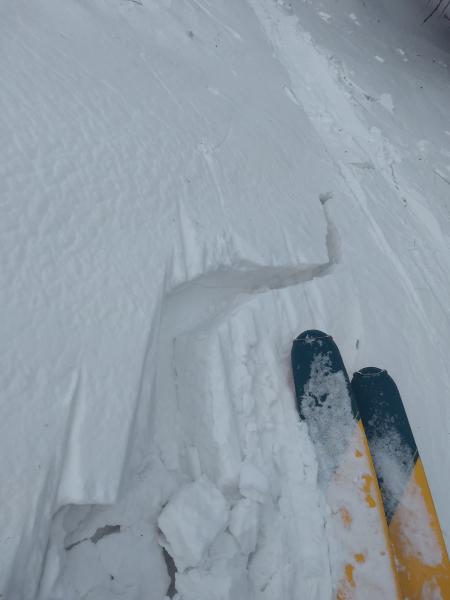
Skier's were surprised to find somewhat sensitive wind slab conditions yesterday (2/11) in drifted terrain in upper Garden City Canyon.
Widespread buried faceted snow exists across the Logan Zone. This is very weak snow, but the suspect weak layers appear dormant currently under a hardening slab, and the snow is stable in most areas for now. |
 |
weather A series of weather disturbances will impact much of Utah through at least Tuesday. After a short break late Tuesday night through early Wednesday, another round of precipitation will expand across the state late Wednesday through Thursday.
|
| general announcements The latest UAC podcast - "Recreating Like a Pro - A Conversation with IFMGA guide Anna Keeling" is live. This podcast will be ideal for anyone looking to pick up some tips and tricks from a professional mountain guide for recreating in the winter backcountry environment. The UAC Marketplace is online. The holiday auction is closed, but our online marketplace still has deals on skis, packs, airbag packs, beacons, snowshoes, soft goods and much more. The UAC has new support programs with Outdoor Research and Darn Tough. Support the UAC through your daily shopping. When you shop at Smith's, or online at Outdoor Research, REI, Backcountry.com, Darn Tough, Patagonia, NRS, Amazon, eBay a portion of your purchase will be donated to the FUAC. See our Donate Page for more details on how you can support the UAC when you shop. Benefit the Utah Avalanche Center when you buy or sell on eBay - set the Utah Avalanche Center as a favorite non-profit in your eBay account here and click on eBay gives when you buy or sell. You can choose to have your seller fees donated to the UAC, which doesn't cost you a penny Check it out on ITunes, Stitcher, the UAC blog, or wherever you get your podcasts. Now is a great time to practice companion rescue techniques with your backcountry partners. Here's our rescue practice video. EMAIL ADVISORY: If you would like to get the daily advisory by email you will need to subscribe here. Remember your information can save lives. If you see anything we should know about, please help us out by submitting snow and avalanche observations. You can also call us at 801-524-5304, email by clicking HERE, or include #utavy in your tweet or Instagram. This advisory is from the U.S.D.A. Forest Service, which is solely responsible for its content. This advisory describes general avalanche conditions and local variations always occur. |