25th Annual Black Diamond Fall Fundraising Party
Thursday, September 13; 6:00-10:00 PM; Black Diamond Parking Lot
25th Annual Black Diamond Fall Fundraising Party
Thursday, September 13; 6:00-10:00 PM; Black Diamond Parking Lot
| Advisory: Logan Area Mountains | Issued by Toby Weed for Monday - February 5, 2018 - 7:22am |
|---|

|
bottom line Heightened avalanche conditions exist on drifted slopes where human triggered wind slab avalanches and cornice falls are possible. Dangerous persistent slab avalanches are unlikely but remain possible on isolated slopes plagued by poor snow structure.
|
 |
special announcement The CROWBAR backcountry ski race is this Saturday February 10 at Swan Peak/Garden City Canyon. More info and registration at http://CrowbarSkiRace.org. |
 |
current conditions Despite nearly constant cloud cover, unwelcome warmth, inccesant west wind, and a bit of rain over the weekend continued to decimate the snowpack, burning off south facing slopes at lower and mid elevations and turning nice trails to mud and ice. The Tony Grove Snotel at 8400' reports rain yesterday and a couple inches of new snow overnight, with .6" SWE in 24 hours. It's 31°F, and there's 56 inches of total snow at the site containing 90% of normal SWE (or Snow Water Equivalent). It's 34°F at the UDOT Hwy 89 Logan Summit sheds, and a west-northwest wind is blowing 20 to 25 mph, with a 60 mph gust early this morning. |
 |
recent activity Other than natural cornice fall and wind slab activity last week at upper elevations, no avalanches were reported recently in the Logan Zone |
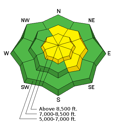
| type | aspect/elevation | characteristics |
|---|

|
|
LIKELIHOOD
 LIKELY
UNLIKELY
SIZE
 LARGE
SMALL
TREND
 INCREASING DANGER
SAME
DECREASING DANGER
|
|
description
Very strong west winds overnight drifted the heavy new snow into lee slope avalanche starting zones and continued to build cornices. You could easily trigger cornice falls and wind slab avalanches around a foot deep in drifted upper elevation terrain, and natural cornice falls are possible as strong westerly winds continue today.
|
| type | aspect/elevation | characteristics |
|---|

|
|
LIKELIHOOD
 LIKELY
UNLIKELY
SIZE
 LARGE
SMALL
TREND
 INCREASING DANGER
SAME
DECREASING DANGER
|
|
description
Avalanches stepping into old snow remain possible on isolated steep slopes in the backcountry. Rain and warm temperatures may be causing a change in slab properties or moistening layers with weak faceted snow on some mid and lower elevation slopes. Also, fresh drifts likely formed on some lee slopes with poor snow structure, overloading weak faceted snow.
|
 |
weather Northwest flow will continue across the Great Basin through the week. A couple of weather disturbances embedded into this northwest flow will cross northern Utah today through Tuesday.
|
| general announcements We have discount lift tickets for Alta, Snowbird, Brighton, Solitude, Snowbasin,and Beaver Mountain. Details and order information here. All proceeds from these go towards paying for avalanche forecasting and education! The latest UAC podcast - "Recreating Like a Pro - A Conversation with IFMGA guide Anna Keeling" is live. This podcast will be ideal for anyone looking to pick up some tips and tricks from a professional mountain guide for recreating in the winter backcountry environment. The UAC Marketplace is online. The holiday auction is closed, but our online marketplace still has deals on skis, packs, airbag packs, beacons, snowshoes, soft goods and much more. The UAC has new support programs with Outdoor Research and Darn Tough. Support the UAC through your daily shopping. When you shop at Smith's, or online at Outdoor Research, REI, Backcountry.com, Darn Tough, Patagonia, NRS, Amazon, eBay a portion of your purchase will be donated to the FUAC. See our Donate Page for more details on how you can support the UAC when you shop. Benefit the Utah Avalanche Center when you buy or sell on eBay - set the Utah Avalanche Center as a favorite non-profit in your eBay account here and click on eBay gives when you buy or sell. You can choose to have your seller fees donated to the UAC, which doesn't cost you a penny Check it out on ITunes, Stitcher, the UAC blog, or wherever you get your podcasts. Now is a great time to practice companion rescue techniques with your backcountry partners. Here's our rescue practice video. EMAIL ADVISORY: If you would like to get the daily advisory by email you will need to subscribe here. Remember your information can save lives. If you see anything we should know about, please help us out by submitting snow and avalanche observations. You can also call us at 801-524-5304, email by clicking HERE, or include #utavy in your tweet or Instagram. This advisory is from the U.S.D.A. Forest Service, which is solely responsible for its content. This advisory describes general avalanche conditions and local variations always occur. |


