25th Annual Black Diamond Fall Fundraising Party
Thursday, September 13; 6:00-10:00 PM; Black Diamond Parking Lot
25th Annual Black Diamond Fall Fundraising Party
Thursday, September 13; 6:00-10:00 PM; Black Diamond Parking Lot
| Advisory: Logan Area Mountains | Issued by Toby Weed for Friday - December 23, 2016 - 6:52am |
|---|

|
bottom line Areas with heightened wind slab avalanche conditions persist on drifted upper elevation slopes, and human triggered avalanches are possible in the backcountry. Although rather unlikely and difficult for a person to trigger, dangerous avalanches involving old snow also remain possible on slopes with poor snow structure.
|
 |
special announcement ***Discount lift tickets for Beaver Mountain, Snowbasin, Powder Mountain, and the Central Wasatch resorts are now available, donated by the resorts to benefit the Utah Avalanche Center. Details and order information here. These make a great holiday gift and all proceeds go towards paying for avalanche forecasting and education! |
 |
current conditions The Tony Grove Snotel at 8400' reports 23 degrees this morning and there's 45" of total snow at the site, containing 110% of average water content for the date. It's 20 degrees at the CSI Logan Peak weather station at 9700', and I'm reading southwest winds averaging around 23 mph. Expect to find a shallowly buried rain-crust at lower elevations of variing thickness and strength and wind-damaged snow in exposed upper and mid elevation terrain, with nice shallow powder conditions still in sheltered terrain. |
 |
recent activity A natural avalanche cycle occurred across the zone last Friday during the storm and included sizable activity on south and east facing slopes. No avalanches were reported locally since then. |
| type | aspect/elevation | characteristics |
|---|

|
|
LIKELIHOOD
 LIKELY
UNLIKELY
SIZE
 LARGE
SMALL
TREND
 INCREASING DANGER
SAME
DECREASING DANGER
|
|
description
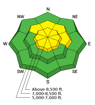
Pockets with heightened danger can be found on drifted upper and mid-elevation slopes, and triggered wind slab avalanches are possible. Wind slabs formed earlier in the week on weak surface snow, and some may be still be sensitive to your weight. Intensifying pre-storm southerly winds may cause drifting and a rise in wind slab danger late in the day.
|
| type | aspect/elevation | characteristics |
|---|

|
|
LIKELIHOOD
 LIKELY
UNLIKELY
SIZE
LARGE
SMALL
TREND
INCREASING DANGER
SAME
DECREASING DANGER
|
|
description
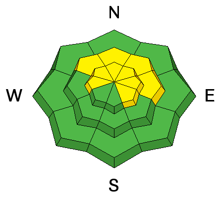
Triggered persistent slab avalanches remain possible on steep slopes at upper and mid elevations. While many slopes currently show increasing stability, mid-pack weak layers consisting of surface hoar or small-grained near surface facets exist on others. Although rather unlikely today, our tests show that you could trigger a dangerous avalanche stepping into old snow in some areas. The incoming Christmas storm will cause a rising danger of persistent slab avalanches in the backcountry this weekend. |
| type | aspect/elevation | characteristics |
|---|

|
|
LIKELIHOOD
LIKELY
UNLIKELY
SIZE
 LARGE
SMALL
TREND
INCREASING DANGER
SAME
DECREASING DANGER
|
|
description
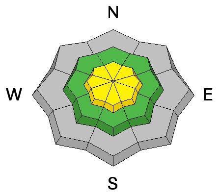
***Dangerous deep slab avalanches, failing on weak faceted snow or depth hoar near the ground remain possible, especially on upper elevation north facing slopes. It would be difficult for a person to trigger a deep slab right now, but an avalanche releasing on weak snow near the ground could be very large and potentially deadly. Deep slab avalanches can be triggered from areas where the slab is thin, like wind-swept, shallow, or rocky areas. For now this problem appears limited to recently drifted slopes that had some snow-cover before Thanksgiving. Additional overloading by drifting snow from the storm on our doorstep will cause the danger of deep slab avalanches to rise on some slopes over the holiday weekend.
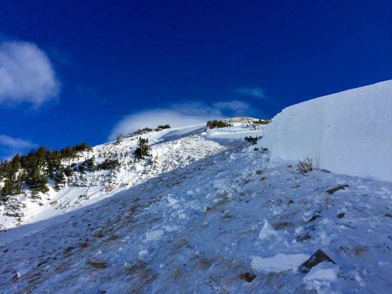
A snowboarder triggered this massive deep slab avalanche Monday afternoon in White Pine Canyon in Little Cottonwood Canyon near Snowbird. Luckily the two riders involved were okay. UAC's Report Here. |
 |
weather The National Weather Service has issued a Winter Storm Warning for most of Utah and southern Idaho. A significant winter storm will affect the region Friday night into late Sunday. A statewide winter storm is expected to bring snow to nearly the entire state, with significant amounts in the mountains and many valley locations seeing decent amounts. Here's the National Weather Service's pre-storm Mountain Weather Briefing: A moist and cold Winter Storm will slowly cross the Great Basin during the weekend. Weather Forecast: Tony Grove Lake (41.897,-111.6535), Elevation: 8800' |
| general announcements The early season is a great time to refresh yourself and practice companion rescue techniques with your partners. Companion Rescue Practice Video Check out Avalanche Canada's "Rescue at Cherry Bowl" story HERE Between now and Jan 15th: Donate to the Utah Avalanche Center by shopping at Whole Foods Market Utah! When you visit any Utah Whole Foods Market locations, bring your re-usable bags, Whole Foods will donate a dime per bag to the Utah Avalanche Center - if you say DONATE my bag credit. We will update this advisory regularly on Monday, Wednesday, Friday, and Saturday mornings by about 7:30... Remember your information can save lives. If you see anything we should know about, please help us out by submitting snow and avalanche observations. You can also call us at 801-524-5304, email by clicking HERE, or include @utavy in your Instagram. In the Logan Area you can get ahold of your local avalanche forcaster, me (Toby Weed), at 435-757-7578 This advisory is from the U.S.D.A. Forest Service, which is solely responsible for its content. This advisory describes general avalanche conditions and local variations always exist. |