| Please join us at the 23rd annual Black Diamond Fall Fundraiser Party Thursday Sept 15. Tickets are on sale now here, at the Black Diamond store & at REI. Special bonus raffle for online ticket purchasers! |
| Please join us at the 23rd annual Black Diamond Fall Fundraiser Party Thursday Sept 15. Tickets are on sale now here, at the Black Diamond store & at REI. Special bonus raffle for online ticket purchasers! |
| Advisory: Logan Area Mountains | Issued by Toby Weed for Friday - April 15, 2016 - 7:15am |
|---|

|
bottom line We are no longer issuing danger ratings, but we can offer backcountry travel advice. Evaluate the snow and terrain carefully, and avoid drifted upper elevation slopes and overhanging cornices. Retreat from steep terrain as the snow softens and becomes saturated in the heat of the day.
|
 |
special announcement We will update the information this advisory intermittently as conditions change for the next couple weeks. Please continue to submit backcountry observations and we will continue to publish them. |
 |
current conditions Along with a good shot of spring snow, yesterday's storm brought welcome colder temperatures. The mercury dropped well below freezing last night for the first time in more than a week. I'm reading 18 degrees at the 9700' CSI Logan Peak station, with northwest winds, currently averaging around 5 mph. The Tony Grove Snotel at 8400' reports 24 degrees and 9 inches of new snow and around an inch of water from yesterday. There's now 78 inches of total snow containing 100% of average water for the date. Heightened avalanche conditions exist in the backcountry today, with storm snow and fresh wind slab avalanches possible in steep upper elevation terrain. Rapid solar warming with the initial clearing this weekend will create a sudden rising danger of loose wet avalanches involving the fresh snow. |
 |
recent activity
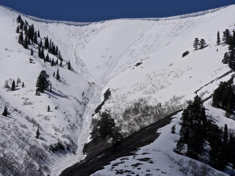
Recent wet avalanche activity in the Wellsville Range after sustained warmth and a long string of nights with above freezing temperatures. (3-12-16, N Hells Canyon from Maple Bench)
|
| type | aspect/elevation | characteristics |
|---|

|

|
LIKELIHOOD
 LIKELY
UNLIKELY
SIZE
 LARGE
SMALL
TREND
 INCREASING DANGER
SAME
DECREASING DANGER
|
description
|
| type | aspect/elevation | characteristics |
|---|

|
|
LIKELIHOOD
LIKELY
UNLIKELY
SIZE
LARGE
SMALL
TREND
 INCREASING DANGER
SAME
DECREASING DANGER
|
|
description
The large wet slab in the Wasatch yesterday indicates potential for this kind of activity around here. Colder temperatures should help matters, but they will be short lived, and you should keep the potential for dangerous wet slabs in mind as you make terrain decisions. Wet slabs are difficult to predict and difficult to trigger. They are also scary because they can be like an avalanche of concrete.
|
 |
weather Today: Snow showers. Some thunder is also possible. High near 36. North northwest wind 7 to 15 mph. Chance of precipitation is 80%. Total daytime snow accumulation of 1 to 3 inches possible.
|
| general announcements The National Avalanche Center recently completed an animated tutorial on the North American Avalanche Danger Scale. HERE Please submit snow and avalanche observations from your ventures in the backcountry HERE. You can call us at 801-524-5304 or email HERE, or include #utavy in your Instagram or Tweet us @UAClogan. To report avalanche activity in the Logan Area or to contact the local avalanche forecaster call me, Toby, at 435-757-7578. We'll be issuing intermittent advisories for the next couple weeks as weather dictates..... This advisory is produced by the U.S.D.A. Forest Service, which is solely responsible for its content. It describes only general avalanche conditions and local variations always exist.
|