| Please join us at the 23rd annual Black Diamond Fall Fundraiser Party Thursday Sept 15. Tickets are on sale now here, at the Black Diamond store & at REI. Special bonus raffle for online ticket purchasers! |  |

| Please join us at the 23rd annual Black Diamond Fall Fundraiser Party Thursday Sept 15. Tickets are on sale now here, at the Black Diamond store & at REI. Special bonus raffle for online ticket purchasers! |  |
| Advisory: Logan Area Mountains | Issued by Toby Weed for Monday - April 11, 2016 - 7:02am |
|---|
 |
special announcement We're winding down for the season and this is our last regular advisory. We will update intermittently as conditions change for the next couple weeks. Please continue to submit backcountry observations and we will continue to publish them. |
 |
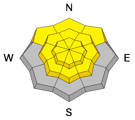
current conditions Temperatures stayed above freezing overnight again at all mountain weather stations, and I'm reading 33 degrees at the 9700' CSI Logan Peak station, with southwest winds, currently averaging around 13 mph. The Tony Grove Snotel at 8400' reports 37 degrees with 76 inches of total snow containing 98% of average water for the date. This is the fith night in a row lacking a freeze ovenight, since April 6.... Expect only a superficial surface refreeze this morning, with the snow softening early again. The danger of wet avalanches will once again rise to moderate on steep slopes by afternoon. Heightened avalanche conditions will develop, with wet avalanches and cornice falls possible. We found good spring riding conditions Friday in Steep Hollow. (3-8-16)
|
 |
recent activity
Examples of recent wet activity in Steep Hollow. (3-8-16) ***To view our updated list of backcountry observations and avalanche activity from around Utah, go to our observations page |
| type | aspect/elevation | characteristics |
|---|


|


|

LIKELIHOOD
 LIKELY
UNLIKELY
SIZE
 LARGE
SMALL
TREND
 INCREASING DANGER
SAME
DECREASING DANGER
|
|
description
Heightened wet avalanche conditions will develop again with daytime warmth. Loose wet sluffs are likely and dangerous wet slab and glide avalanches are possible in steep terrain. |
| type | aspect/elevation | characteristics |
|---|


|


|

LIKELIHOOD
 LIKELY
UNLIKELY
SIZE
 LARGE
SMALL
TREND
 INCREASING DANGER
SAME
DECREASING DANGER
|
|
description
Cornices have started to buckle with the warmth and some are likely to naturally calve off during daytime heating, and these can trigger wet avalanches on slopes below. As the large overhanging cornices soften with the warmth they can also become easier to trigger and often break further back than expected. Obviously, you should avoid travel on and under large cornices in the heat of the day.
Cornice Falls are likely during the heat of the day. (N Hell's 4-6-16)
|
 |
weather Although somewhat unlikely, scattered rain, snow, and thunder showers are possible again today, and it'll be mostly cloudy in the mountains. Expect a high temperature at 9000' of around 50 degrees and an increasing light west wind. Rain and snow showers will be possible again tonight, with a low around 34 degrees and continuing light west wind. The weather on Tuesday will be quite similar to today's, perhaps a few degrees warmer. A stronger and colder storm system is expected to impact the area during the latter part of the week.
|
| general announcements The National Avalanche Center recently completed an animated tutorial on the North American Avalanche Danger Scale. HERE Please submit snow and avalanche observations from your ventures in the backcountry HERE. You can call us at 801-524-5304 or email HERE, or include #utavy in your Instagram or Tweet us @UAClogan. To report avalanche activity in the Logan Area or to contact the local avalanche forecaster call me, Toby, at 435-757-7578. We'll be issuing intermittent advisories for the next couple weeks as weather dictates..... This advisory is produced by the U.S.D.A. Forest Service, which is solely responsible for its content. It describes only general avalanche conditions and local variations always exist.
|
Advisory Hotline: (888) 999-4019 | Contact Information