| Please join us at the 23rd annual Black Diamond Fall Fundraiser Party Thursday Sept 15. Tickets are on sale now here, at the Black Diamond store & at REI. Special bonus raffle for online ticket purchasers! |
| Please join us at the 23rd annual Black Diamond Fall Fundraiser Party Thursday Sept 15. Tickets are on sale now here, at the Black Diamond store & at REI. Special bonus raffle for online ticket purchasers! |
| Advisory: Logan Area Mountains | Issued by Toby Weed for Thursday - April 7, 2016 - 7:13am |
|---|

|
bottom line MODERATE (Level 2): Heightened wet avalanche conditions will develop in steep terrain as saturated snow warms and softens up with today's exceptionally warm daytime temperatures and intense solar heating. Conditions may become dangerous on some slopes this afternoon with large natural cornice fall and long running loose wet avalanches possible in some areas. Evaluate the snow and terrain carefully, avoid travel under cornices, and retreat from steep slopes if you start sinking into melt-softened wet snow.
|
 |
current conditions Temperatures stayed above freezing overnight at all mountain weather stations, and I'm reading 35 degrees at the 9700' CSI Logan Peak weather station, with north-northwest winds currently averaging around 15 mph. The Tony Grove Snotel at 8400' reports 84 inches of total snow containing 101% of average water for the date. The snow in the Wellsvilles softened up a bit earlier than we expected yesterday, and we were sinking too deeply into wet snow in places around noon. Expect only a superficial surface refreeze this morning, with the snow softening up even earlier today. Avalanche conditions could become dangerous on some sunny slopes in the afternoon with natural cornice fall and large entraining loose wet sluffs possible.
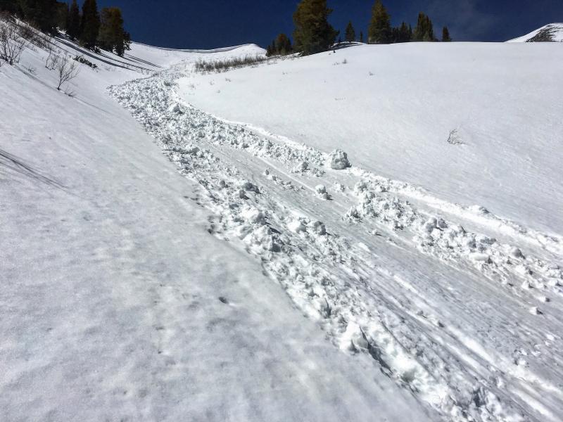
This long running natural loose wet slide in Old Logway was triggered by cornice fall, we think on Sunday 4-3-16. More natural wet avalanche activity is possible with exceptionally warm daytime temperatures expected in the mountains today and tomorrow.
|
 |
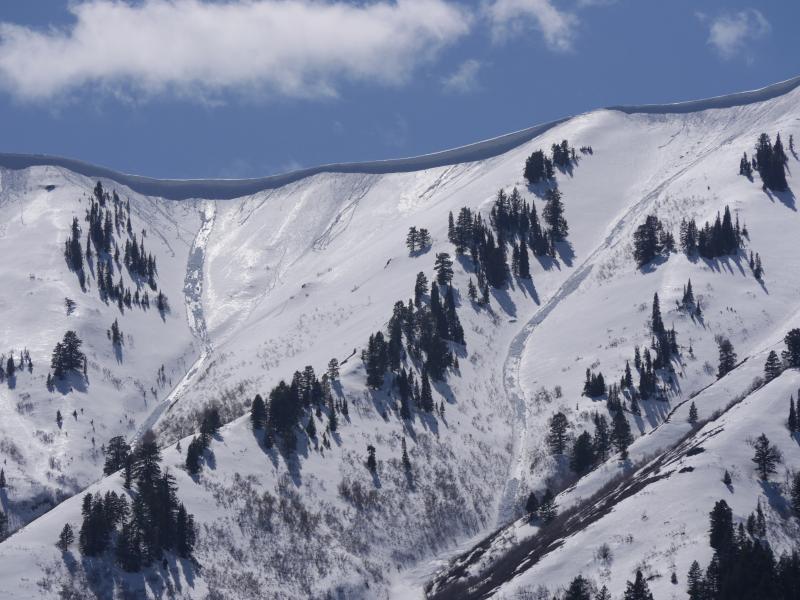
recent activity Natural wet avalanches during the heat of the day and involving late March snow were common across the Logan Zone in the first few days of April. These long natural wet avalanches in the Wellsville Mountain Wilderness occurred during the weekend warm spell or on Monday (4-4-16) ***To view our updated list of backcountry observations and avalanche activity from around Utah, go to our observations page |
| type | aspect/elevation | characteristics |
|---|

|

|
LIKELIHOOD
 LIKELY
UNLIKELY
SIZE
 LARGE
SMALL
TREND
 INCREASING DANGER
SAME
DECREASING DANGER
|
|
description
Moist sluffs entraining melt-saturated surface snow are possible with warming daytime temperatures again today, most likely on sunny sheltered slopes where saturated surface snow becomes softened by solar warming. You should leave a steep slope if you start sinking into melt-softened wet snow. With mountain temperatures well into the 50s today, natural wet avalanches will be possible in the afternoon. Dangerous triggered wet slabs may also be a possibility in very steep sunny terrain as slopes with shallow snow continue to heat up this afternoon and tomorrow...
|
| type | aspect/elevation | characteristics |
|---|

|
|
LIKELIHOOD
LIKELY
UNLIKELY
SIZE
LARGE
SMALL
TREND
INCREASING DANGER
SAME
DECREASING DANGER
|
|
description
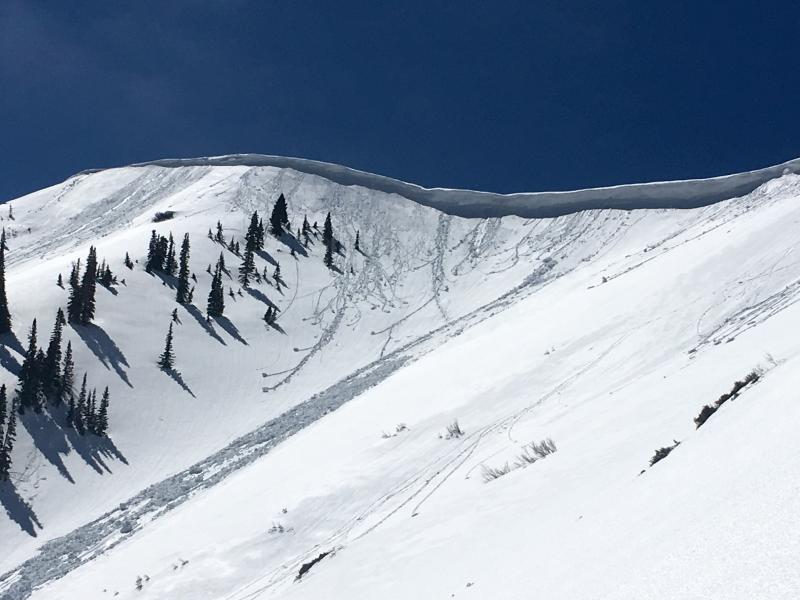
Avoid travel under large cornices in the heat of the day. Cornices are likely to buckle and naturally calve during daytime heating, and these can trigger wet avalanches on slopes below. As the large overhanging cornices soften with the warmth they can also become easier to trigger and often break further back than expected.
Cornice Falls are likely during the heat of the day. (N Hell's 4-6-16)
|
 |
weather HIGH PRESSURE ALOFT WILL CONTINUE TO BRING DRY CONDITIONS AND A WARMING TREND TO UTAH TODAY. A LOW PRESSURE SYSTEM ADVANCING TOWARD THE SOUTHERN CALIFORNIA COAST WILL SPREAD MOISTURE NORTH INTO UTAH BEGINNING FRIDAY. A SECOND LOW PRESSURE SYSTEM WILL BRING PRECIPITATION BACK TO UTAH LATE IN THE WEEKEND.
|
| general announcements The National Avalanche Center recently completed an animated tutorial on the North American Avalanche Danger Scale. HERE Please submit snow and avalanche observations from your ventures in the backcountry HERE. You can call us at 801-524-5304 or email HERE, or include #utavy in your Instagram or Tweet us @UAClogan. To report avalanche activity in the Logan Area or to contact the local avalanche forecaster call me, Toby, at 435-757-7578. We'll update this advisory throughout the season on Monday, Wednesday, Friday, and Saturday mornings by about 7:30. This is the final week of regular advisories and we'll be issuing intermittent advisories as weather dictates starting next week (4-11-16) This advisory is produced by the U.S.D.A. Forest Service, which is solely responsible for its content. It describes only general avalanche conditions and local variations always exist.
|