| Please join us at the 23rd annual Black Diamond Fall Fundraiser Party Thursday Sept 15. Tickets are on sale now here, at the Black Diamond store & at REI. Special bonus raffle for online ticket purchasers! |
| Please join us at the 23rd annual Black Diamond Fall Fundraiser Party Thursday Sept 15. Tickets are on sale now here, at the Black Diamond store & at REI. Special bonus raffle for online ticket purchasers! |
| Advisory: Logan Area Mountains | Issued by Toby Weed for Monday - April 4, 2016 - 7:01am |
|---|

|
bottom line CONSIDERABLE (level 3): Dangerous wet avalanche conditions will again develop due to solar and seasonal heating in the backcountry. Natural and triggered wet avalanches are likely during the heat of the day, and could occur even in north facing and upper elevation terrain. Careful snowpack evaluation, cautious route-finding, and conservative decision making recommended, and continue to stay off of and out from under steep slopes with melt softened and saturated surface snow.
|
 |
current conditions The weekend warm-up and powerful spring sun turned last week's fresh snow into slush on sunny slopes and to the consistency of sticky mashed potatoes in shady terrain. There isn't much powder left in the Logan Zone, perhaps a few scraps in the highest north facing terrain. Nice supportable spring "corn" conditions have yet to develop, lacking good overnight refreezes. The Tony Grove Snotel at 8400' reports 37 degrees and there's 89 inches of total snow containing 103% of average water for the date. The site lost a half inch of water equivalent yesterday. I'm reading 37 degrees at the 9700' CSI Logan Peak weather station, with south-southwest winds currently averaging 14 mph.
|
 |
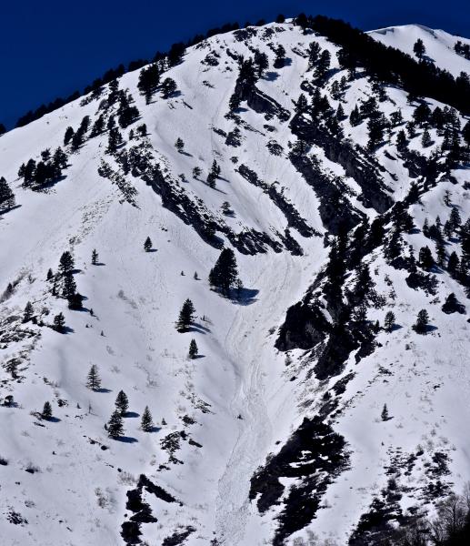
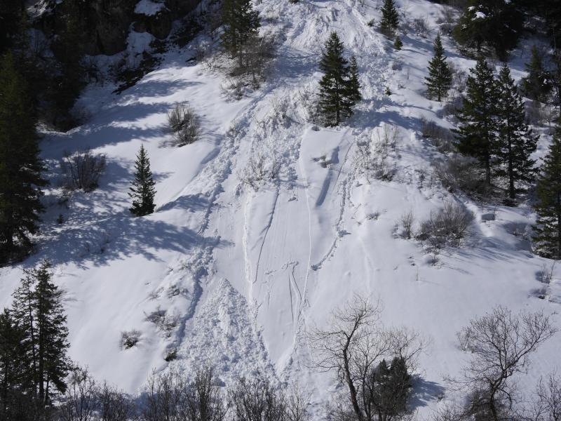
recent activity Natural wet avalanches during the heat of the day and involving late March snow have been fairly common across the zone in the first few days of April.
An example of natural loose wet activity in lower Providence Canyon (4-1-16) ***To view our updated list of backcountry observations and avalanche activity from around Utah, go to our observations page |
| type | aspect/elevation | characteristics |
|---|

|

|
LIKELIHOOD
 LIKELY
UNLIKELY
SIZE
 LARGE
SMALL
TREND
 INCREASING DANGER
SAME
DECREASING DANGER
|
|
description
Moist sluffs entraining significant piles of melt-saturated fresh snow from last week are possible and could become likely again today, even in north facing and upper elevation terrain.
|
 |
weather A cold front will brush through the zone today, and rain and snow showers will become likely in the afternoon. Some thunder is possible. It'll be mostly cloudy with 9000' high temperatures around 48 degrees! Expect increasing west winds this afternoon, with gusts close to 40 mph. Not much accumulation is expected. Scattered rain, snow, and thunder showers are possible tonight, with mountain temperatures dropping to around 22 degrees. It should be clearing, breezy, and becoming mostly sunny tomorrow with a high near 36 and continued west winds.
|
| general announcements The National Avalanche Center recently completed an animated tutorial on the North American Avalanche Danger Scale. HERE Please submit snow and avalanche observations from your ventures in the backcountry HERE. You can call us at 801-524-5304 or email HERE, or include #utavy in your Instagram or Tweet us @UAClogan. To report avalanche activity in the Logan Area or to contact the local avalanche forecaster call me, Toby, at 435-757-7578. We'll update this advisory throughout the season on Monday, Wednesday, Friday, and Saturday mornings by about 7:30 This advisory is produced by the U.S.D.A. Forest Service, which is solely responsible for its content. It describes only general avalanche conditions and local variations always exist.
|