| Please join us at the 23rd annual Black Diamond Fall Fundraiser Party Thursday Sept 15. Tickets are on sale now here, at the Black Diamond store & at REI. Special bonus raffle for online ticket purchasers! |
| Please join us at the 23rd annual Black Diamond Fall Fundraiser Party Thursday Sept 15. Tickets are on sale now here, at the Black Diamond store & at REI. Special bonus raffle for online ticket purchasers! |
| Advisory: Logan Area Mountains | Issued by Toby Weed for Saturday - March 26, 2016 - 6:40am |
|---|

|
bottom line MODERATE (level 2): Use normal caution and evaluate the snow and terrain carefully, especially in drifted terrain. Pockets with heightened cornice fall and wind slab conditions exist on drifted slopes at upper elevations in the backcountry. Cool temperatures and clouds should keep the danger of loose wet avalanches low today, but the danger will likely rise on most slopes with much warmer daytime temperatures expected in the mountains on Sunday.
|
 |
current conditions The Tony Grove Snotel at 8400' reports 18 degrees this morning and perhaps a couple inches of light new snow overnight. There's 93 inches of total snow containing 105% of average water for the date. I'm reading 12 degrees at the 9700' CSI Logan Peak weather station, with east northeast winds currently averaging 11 mph after a fairly calm night. Observers report nice powder conditions yesterday at upper elevations on north facing and forested slopes. You'll find shallow powder from yesterday on a sun-crust of varying thickness from Wednesday elsewhere, with mostly supportable refrozen (hard) snow, and dust-on-crust down low.
|
 |
recent activity
***To view our updated list of backcountry observations and avalanche activity from around Utah, go to our observations page
|
| type | aspect/elevation | characteristics |
|---|

|
|
LIKELIHOOD
 LIKELY
UNLIKELY
SIZE
 LARGE
SMALL
TREND
 INCREASING DANGER
SAME
DECREASING DANGER
|
|
description
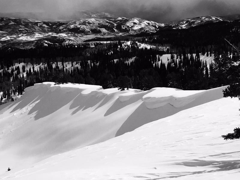
Beware large overhanging ridge-top cornices, which could break further back than you expect and might trigger avalanches on drifted slopes below. Heightened cornice fall conditions exist at upper elevations due to significant drifting of the recent accumulations. I easily triggered a fairly large cornice fall Thursday. The forming cornice broke at my skis, around 3' deep and maybe 30' wide. Natural and triggered cornice falls are possible again today. Warmer mountain temperatures on Sunday may cause some cornices to naturally buckle, collapse, or calve off during the heat of the day.
Sizable cornices continued to grow this week with sustained northwest winds and more fresh snow to drift. Chicken Hill in Bunch Grass, (Pagnucco 3-25-16)
|
| type | aspect/elevation | characteristics |
|---|

|

|
LIKELIHOOD
LIKELY
UNLIKELY
SIZE
LARGE
SMALL
TREND
 INCREASING DANGER
SAME
DECREASING DANGER
|
|
description
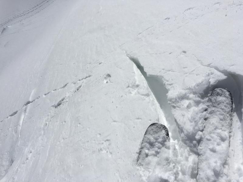
Pockets with heightened wind slab avalanche conditions exist due to significant recent accumulations and drifting in upper elevation terrain. I think the very deep drifts that formed earlier in the week due to sustained northwest and westerly winds are now pretty well bonded to the older snow in most areas, but there might be a few stiff older wind slabs out there under a few inches of fresh snow that a person could trigger in steep terrain. Winds yesterday and overnight were fairly light, but they're coming from the east (ENE) this morning and some drifting of yesterday's light powder is probably still occurring. Shallow fresh wind slabs might be found today in rather unusual or unexpected places. Watch for and avoid drifted snow on the lee sides of ridges, cross-loaded along sub-ridges, and in and around terrain features like rock outcroppings, gullies, scoops, trees, and saddles. Cracking in the snow surface is a sign of potential wind slab instability.
Cracking like this is a red flag indicating potential soft slab (or wind slab) instability. (photo from 3-23-16)
|
| type | aspect/elevation | characteristics |
|---|

|
|
LIKELIHOOD
 LIKELY
UNLIKELY
SIZE
 LARGE
SMALL
TREND
 INCREASING DANGER
SAME
DECREASING DANGER
|
|
description
Temperatures should remain pretty cool and cloud cover should keep a lid on the wet avalanche problem today, but if the high-angled March sun comes out for even a little while, loose wet avalanches entraining a good amount of fresh snow will become possible, especially in sheltered sunny terrain. If the snow on the slope you're on is saturated or sticky due to warmth, you should leave and head for more shady terrain. Loose wet avalanches are likely to be more of an issue Sunday, as mountain temperatures warm significantly. |
 |
weather Snow showers are possible today in the mountains, and it'll be mostly cloudy, with a high temperature at 9000' around 29 degrees and fairly light east wind. Expect partly cloudy conditions tonight, with a low around 18 and light west winds veering from the southwest late. We'll see partly sunny skies with a high near 40 degrees and increasing west southwest winds on Sunday. A much stronger storm system will move into the region early next week and is expected to affect the weather through midweek.
|
| general announcements The National Avalanche Center recently completed an animated tutorial on the North American Avalanche Danger Scale. HERE Please submit snow and avalanche observations from your ventures in the backcountry HERE. You can call us at 801-524-5304 or email HERE, or include #utavy in your Instagram or Tweet us @UAClogan. To report avalanche activity in the Logan Area or to contact the local avalance forecaster call me, Toby, at 435-757-7578. We'll update this advisory throughout the season on Monday, Wednesday, Friday, and Saturday mornings by about 7:30 This advisory is produced by the U.S.D.A. Forest Service, which is solely responsible for its content. It describes only general avalanche conditions and local variations always exist.
|