| Please join us at the 23rd annual Black Diamond Fall Fundraiser Party Thursday Sept 15. Tickets are on sale now here, at the Black Diamond store & at REI. Special bonus raffle for online ticket purchasers! |
| Please join us at the 23rd annual Black Diamond Fall Fundraiser Party Thursday Sept 15. Tickets are on sale now here, at the Black Diamond store & at REI. Special bonus raffle for online ticket purchasers! |
| Advisory: Logan Area Mountains | Issued by Toby Weed for Wednesday - March 16, 2016 - 6:50am |
|---|

|
bottom line CONSIDERABLE (level 3): Stellar deep Utah powder in the backcountry, but areas with potentially dangerous wind slab and cornice fall conditions exist. Human triggered avalanches are likely in some drifted upper elevation terrain. The danger of loose wet avalanches will skyrocket if the sun pops out for a while and warms slopes with significant deposits of new snow. Use careful snow and terrain evaluation and cautious decision making in the backcountry, and continue to avoid steep drifted slopes at upper elevations.
|
 |
special announcement ***Please take time to complete a quick survey that will help us better serve you in the future. HERE
|
 |
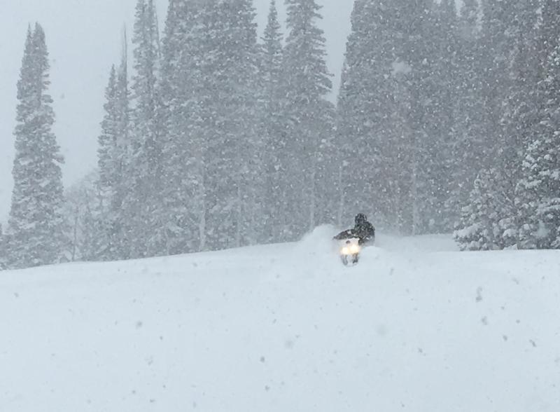
current conditions The Tony Grove Snotel at 8400' reports 20 degrees with snowfall continuing overnight and around two-and-a-half feet of new powder ! The station shows 3.2" of snow water equivalent in the last 48 hrs and 1.3" in the last 24. There's now 96 inches of total snow containing 102% of average water for the date. I'm reading 13 degrees at the 9700' CSI Logan Peak weather station, but the wind sensor still appears to be encased in rime. Mt Ogden shows a bit of a bump in wind speeds this morning, with sustained westerlies averaging 25 to 35 mph. Beaver Mt expects another very good powder day, with periods of heavy snow all day yesterday refilling tracks, and several more inches of accumulation overnight.
We found very nice deep powder riding conditions in the Bear River Range backcountry yesterday (3-15-16).
|
 |
recent activity
***To view our updated list of backcountry observations and avalanche activity from around Utah, go to our observations page
|
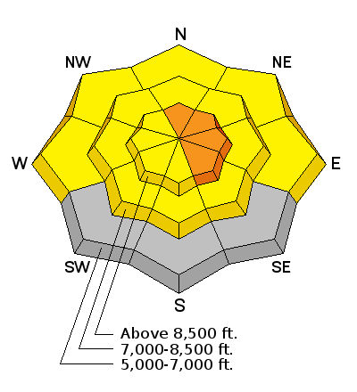
| type | aspect/elevation | characteristics |
|---|

|
|
LIKELIHOOD
 LIKELY
UNLIKELY
SIZE
 LARGE
SMALL
TREND
 INCREASING DANGER
SAME
DECREASING DANGER
|
|
description
Areas with potentially dangerous wind slab avalanche and cornice fall conditions exist in drifted upper elevation terrain. Sustained westerly wind, sometimes during periods of heavy snowfall in the past couple days continued yesterday evening and overnight. The wind picked up fresh powder in upper elevation fetch areas and drifted it into lee slope avalanche starting zones.
|
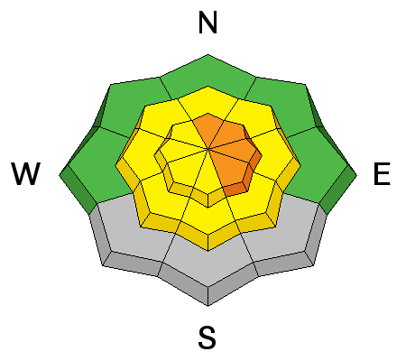
| type | aspect/elevation | characteristics |
|---|

|
|
LIKELIHOOD
 LIKELY
UNLIKELY
SIZE
LARGE
SMALL
TREND
 INCREASING DANGER
SAME
DECREASING DANGER
|
|
description
If it stays cold and cloudy, there will be no loose wet avalanche problem. But, if the sun pops out for a bit and moistens the fresh snow, loose wet avalanches entraining the sticky fresh snow will become likely and could be fairly large.
|
 |
weather From the National Weather Service in SLC. A COOL AND SOMEWHAT MOIST NORTHWEST FLOW WILL PERSIST OVER NORTHERN UTAH TODAY. HIGH PRESSURE ALOFT WILL RETURN TO THE REGION LATE IN THE WEEK. |
| general announcements The National Avalanche Center recently completed an animated tutorial on the North American Avalanche Danger Scale. Please submit snow and avalanche observations from your ventures in the backcountry HERE. You can call us at 801-524-5304 or email HERE, or include #utavy in your Instagram or Tweet us @UAClogan. To report avalanche activity in the Logan Area or to contact the local avalance forecaster call me, Toby, at 435-757-7578. We'll update this advisory throughout the season on Monday, Wednesday, Friday, and Saturday mornings by about 7:30 This advisory is produced by the U.S.D.A. Forest Service, which is solely responsible for its content. It describes only general avalanche conditions and local variations always exist.
|