| Please join us at the 23rd annual Black Diamond Fall Fundraiser Party Thursday Sept 15. Tickets are on sale now here, at the Black Diamond store & at REI. Special bonus raffle for online ticket purchasers! |
| Please join us at the 23rd annual Black Diamond Fall Fundraiser Party Thursday Sept 15. Tickets are on sale now here, at the Black Diamond store & at REI. Special bonus raffle for online ticket purchasers! |
| Advisory: Logan Area Mountains | Issued by Toby Weed for Tuesday - March 15, 2016 - 7:31am |
|---|

|
bottom line CONSIDERABLE (level 3): Dangerous wind slab avalanche conditions probably exist today in drifted upper and mid elevation terrain. Continuing snowfall and intensifying westerly winds will cause drifting to continue throughout the day. Soft slab and loose snow avalanches involving the copious new snow are possible on steep slopes, and loose wet avalanches will become likely next time the sun warms slopes with significant deposits of new snow. Use careful snow and terrain evaluation and cautious decision making in the backcountry today, and avoid steep drifted slopes at upper elevations.
|
 |
special announcement ***Please take time to complete a quick survey that will help us better serve you in the future. HERE
|
 |
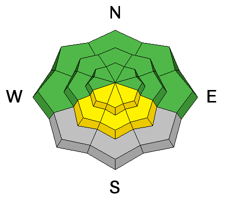
current conditions The Tony Grove Snotel at 8400' reports 17 degrees and nearing a couple feet of new snow, with continuing snowfall, 2.4" of water in the last 48 hrs and 1.9" in the last 24! There's 86 inches of total snow containing 98% of average water for the date. I'm reading 10 degrees at the 9700' CSI Logan Peak weather station, but the wind sensor appears to be encased in rime. Mt Ogden shows a decrease in wind speeds since yesterday morning's crazy weather, but I'm still reading sustained westerlies averaging around 25 mph. The National Weather Service in Salt Lake City has continued a Winter Weather Advisory for the mountains of Northern Utah, (north of I-80) with continued snow showers, a few more inches of accumulation, and drifting from intensifying westerly winds expected in the mountains. Beaver Mt expects very good powder conditions today, with snow all day yesterday refilling tracks, and a few more inches overnight.
|
 |
recent activity
On Saturday (3-12-16) around noon, I saw a recent loose wet avalanche and stopped to gather the riders in our level 1 class. As several of us waited for the rest to join we watched as a second wet avalanche occurred right next to the first one. ***To view our updated list of backcountry observations and avalanche activity from around Utah, go to our observations page
|
| type | aspect/elevation | characteristics |
|---|

|
|
LIKELIHOOD
 LIKELY
UNLIKELY
SIZE
 LARGE
SMALL
TREND
 INCREASING DANGER
SAME
DECREASING DANGER
|
|
description
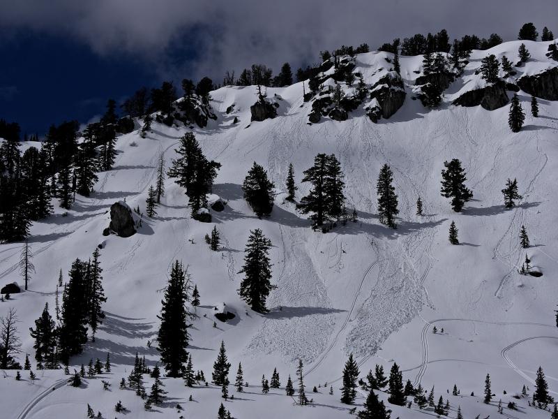
Dangerous wind slab avalanche and cornice fall conditions probably exist in drifted upper and mid elevation terrain. Strong southwest and west wind, sometimes during periods of heavy snowfall yesterday moderated a bit but continued overnight. The wind picked up the fresh snow in upper elevation fetch areas and drifted it into lee slope avalanche starting zones. We expect drifting will continue with increasing west wind today.
|
| type | aspect/elevation | characteristics |
|---|

|

|
LIKELIHOOD
 LIKELY
UNLIKELY
SIZE
LARGE
SMALL
TREND
 INCREASING DANGER
SAME
DECREASING DANGER
|
|
description
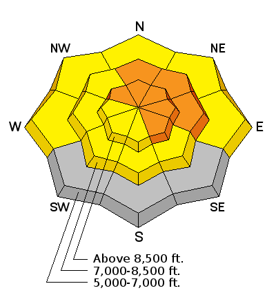
In some areas the new snow may not bond very well with last week's warm snow surface and 1 to 2-foot-deep soft slab avalanches involving the new snow are possible in some steep terrain.
|
| type | aspect/elevation | characteristics |
|---|

|
|
LIKELIHOOD
LIKELY
UNLIKELY
SIZE
LARGE
SMALL
TREND
INCREASING DANGER
SAME
DECREASING DANGER
|
|
description
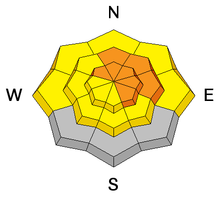
If it stays cold and cloudy, there will be no loose wet avalanche problem. But, if the sun pops out for a bit and moistens the fresh snow, loose wet avalanches entraining the sticky fresh snow will become likely and could be fairly large. |
 |
weather From the National Weather Service in SLC. A COLD...MOIST AND UNSTABLE AIR MASS WILL MAINTAIN SHOWERY PRECIPITATION ACROSS NORTHERN UTAH THROUGH MIDWEEK. HIGH PRESSURE ALOFT WILL RETURN TO THE REGION LATE IN THE WEEK. Today: Snow showers. High near 23. Wind chill values as low as -4. Breezy, with a west wind 18 to 23 mph increasing to 24 to 29 mph in the afternoon. Winds could gust as high as 43 mph. Chance of precipitation is 90%. Total daytime snow accumulation of 3 to 7 inches possible. |
| general announcements The National Avalanche Center recently completed an animated tutorial on the North American Avalanche Danger Scale. Please submit snow and avalanche observations from your ventures in the backcountry HERE. You can call us at 801-524-5304 or email HERE, or include #utavy in your Instagram or Tweet us @UAClogan. To report avalanche activity in the Logan Area or to contact the local avalance forecaster call me, Toby, at 435-757-7578. We'll update this advisory throughout the season on Monday, Wednesday, Friday, and Saturday mornings by about 7:30 This advisory is produced by the U.S.D.A. Forest Service, which is solely responsible for its content. It describes only general avalanche conditions and local variations always exist.
|