| Please join us at the 23rd annual Black Diamond Fall Fundraiser Party Thursday Sept 15. Tickets are on sale now here, at the Black Diamond store & at REI. Special bonus raffle for online ticket purchasers! |
| Please join us at the 23rd annual Black Diamond Fall Fundraiser Party Thursday Sept 15. Tickets are on sale now here, at the Black Diamond store & at REI. Special bonus raffle for online ticket purchasers! |
| Advisory: Logan Area Mountains | Issued by Toby Weed for Saturday - March 12, 2016 - 6:52am |
|---|

|
bottom line MODERATE (level 2): Cooler temperatures, a westerly breeze, and cloud cover will help reduce the wet avalanche problem today. The snow is mostly stable in the backcountry, but pockets with heightened cornice fall and wind slab conditions may exist in drifted upper elevation terrain and loose wet avalanches are again possible on slopes with warmth softened saturated snow. Use normal caution.
|
 |
special announcement The National Avalanche Center recently completed an animated tutorial on the North American Avalanche Danger Scale. |
 |
current conditions
The Tony Grove Snotel at 8400' reports 38 degrees this morning and there's 70 inches of total snow containing 93% of average water for the date. Temperatures recently dropped below freezing this morning and they continue to fall at the 9700' CSI Logan Peak weather station. I'm currently reading 27 degrees, with southwest winds currently averaging in the teens, but with stronger overnight winds and a gust of 43 mph early this morning. Around a foot of fresh snow fell Wednesday morning at upper elevations in the central and northern Bear River Range, and a rapid warm-up quickly turned the nice powder into mashed potatoes even at upper elevations. Crusty and/or soft moist snow conditions are a good bet for most areas this weekend.
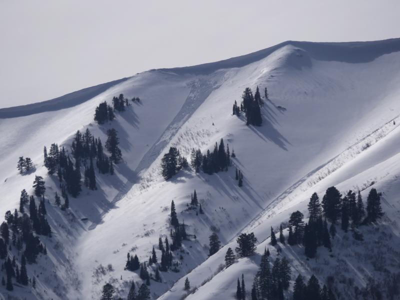
A natural loose wet avalanche triggered by cornice fall yesterday, (3-10-16) in Old Logway Canyon in the Wellsville Mt Wilderness. |
 |
recent activity
***To view our updated list of backcountry observations and avalanche activity from around Utah, go to our observations page
|
| type | aspect/elevation | characteristics |
|---|

|
|
LIKELIHOOD
 LIKELY
UNLIKELY
SIZE
 LARGE
SMALL
TREND
 INCREASING DANGER
SAME
DECREASING DANGER
|
|
description
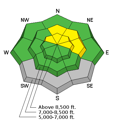
Pockets with heightened cornice fall and wind slab avalanche conditions probably still exist today in some previously drifted upper elevation terrain. The warmth and surface dampness kept the snow from drifting much in the past couple days despite sustained southwest winds. But as usual, you should still use caution in drifted terrain at upper elevations..
|
| type | aspect/elevation | characteristics |
|---|

|
|
LIKELIHOOD
LIKELY
UNLIKELY
SIZE
LARGE
SMALL
TREND
 INCREASING DANGER
SAME
DECREASING DANGER
|
|
description
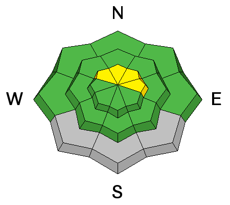
A weak storm system passing through the zone this morning brought clouds and a few rain drops, and caused a significant and welcome drop in temperatures at upper elevations. Overnight temperatures stayed well above freezing at local mountain weather stations, but cooling temperatures, cloud cover, and a nice westerly breeze will probably keep the snow from softening too much today. Never-the-less, wet activity is possible on slopes with warmth softened saturated snow today, and what if the sun pops out for a bit or temperatures rise further than expected with daytime warming?
|
 |
weather Expect cloudy and breezy weather today, with west southwest winds averaging in the mid teens along the ridges and a high temperature at 9000' around 40 degrees. It'll be mostly cloudy tonight with a low around 29 degrees and continuing west southwest winds and a chance of snow showers. A series of cool and moist storms will begin to impact the region on Sunday and continue well into next week. Snow is likely to begin by tomorrow afternoon, with a high temperature around 35 degrees and west winds, with 1 to 3 inches of accumulation possible by evening. A foot of new snow could accumulate in some mountain areas by Monday night.
|
| general announcements Please submit snow and avalanche observations from your ventures in the backcountry HERE. You can call us at 801-524-5304 or email HERE, or include #utavy in your Instagram or Tweet us @UAClogan. To report avalanche activity in the Logan Area or to contact the local avalanche forecaster call me, Toby, at 435-757-7578. We'll update this advisory throughout the season on Monday, Wednesday, Friday, and Saturday mornings by about 7:30 This advisory is produced by the U.S.D.A. Forest Service, which is solely responsible for its content. It describes only general avalanche conditions and local variations always exist.
|