| Please join us at the 23rd annual Black Diamond Fall Fundraiser Party Thursday Sept 15. Tickets are on sale now here, at the Black Diamond store & at REI. Special bonus raffle for online ticket purchasers! |
| Please join us at the 23rd annual Black Diamond Fall Fundraiser Party Thursday Sept 15. Tickets are on sale now here, at the Black Diamond store & at REI. Special bonus raffle for online ticket purchasers! |
| Advisory: Logan Area Mountains | Issued by Toby Weed for Friday - March 11, 2016 - 7:23am |
|---|

|
bottom line MODERATE (level 2): Heightened wind slab and cornice fall conditions exist, and you might trigger avalanches today in drifted upper elevation terrain. Exceptionally warm temperatures forecast for the mountains again today, and loose wet avalanches entraining significant piles of fresh snow are possible on steep slopes at all elevations. Evaluate the snow and terrain carefully, and stay off and out from under steep slopes with saturated surface snow.
|
 |
current conditions
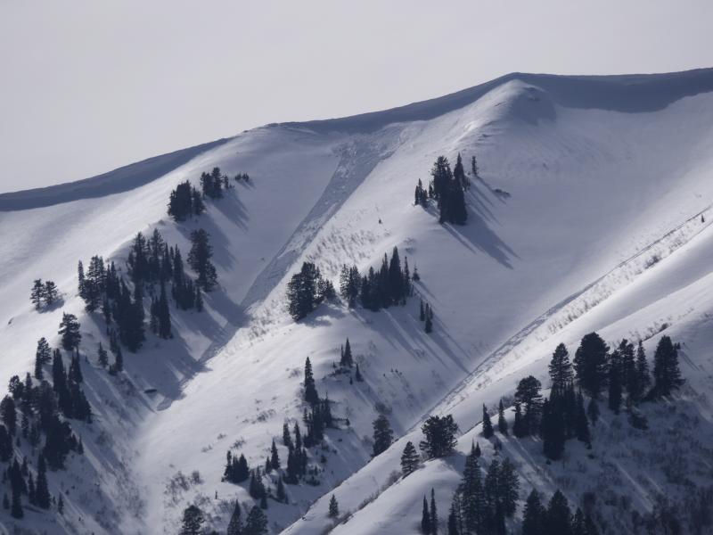
The Tony Grove Snotel at 8400' reports 42 degrees this morning and there's 72 inches of total snow containing 95% of average water for the date. It's 33 degrees at the 9700' CSI Logan Peak weather station with southwest winds currently averaging 25 mph. Around a foot of fresh snow fell Wednesday morning at upper elevations in the central and northern Bear River Range, and yesterday's rapid warm-up quickly turned the nice powder into mashed potatoes even at upper elevations.
A natural loose wet avalanche triggered by cornice fall yesterday, (3-10-16) in Old Logway Canyon in the Wellsville Mt Wilderness. |
 |
recent activity
***To view our updated list of backcountry observations and avalanche activity from around Utah, go to our observations page
|
| type | aspect/elevation | characteristics |
|---|

|
|
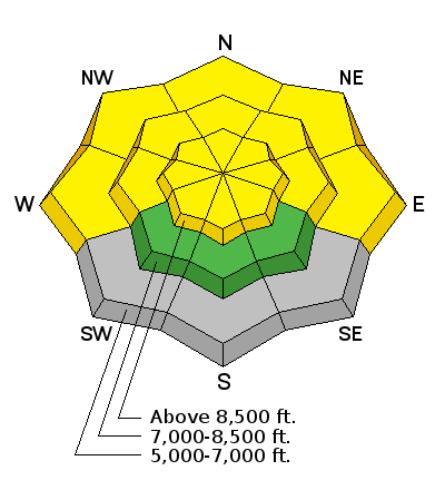
LIKELIHOOD
 LIKELY
UNLIKELY
SIZE
 LARGE
SMALL
TREND
 INCREASING DANGER
SAME
DECREASING DANGER
|
|
description
Heightened cornice fall and wind slab avalanche conditions exist today in drifted upper elevation terrain, and strong and sustained southwest winds may find a bit more soft snow to drift into slabs at upper elevations.
|
| type | aspect/elevation | characteristics |
|---|

|
|
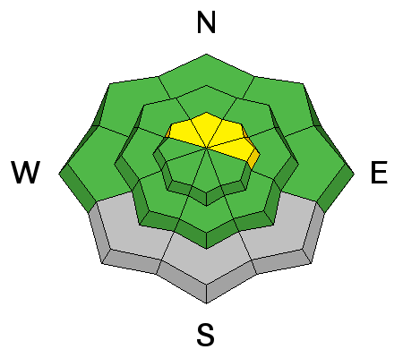
LIKELIHOOD
 LIKELY
UNLIKELY
SIZE
LARGE
SMALL
TREND
 INCREASING DANGER
SAME
DECREASING DANGER
|
|
description
Loose wet avalanches entraining Wednesday's fresh snow are possible on slopes at all elevations during the heat of the day. Sheltered upper and mid elevation north facing slopes are especially suspect due to the exceptionally warm air temperatures.
|
 |
weather A warm southwest flow will continue over the region today. A weak system will cross over the zone tonight and Saturday. A series of cool and moist storms will begin to impact the region on Sunday and continue well into next week. Expect sunny and breezy weather today, with southwest winds averaging in the mid twenties along the ridges and a high temperature at 9000' around 51 degrees! It'll be mostly cloudy tonight with a low around 35 degrees and south southwest winds. It'll be cloudy tomorrow with west southwest winds averaging in the mid teens, high temperatures around 41 degrees and a 40% chance of snow showers.
|
| general announcements Please submit snow and avalanche observations from your ventures in the backcountry HERE. You can call us at 801-524-5304 or email HERE, or include #utavy in your Instagram or Tweet us @UAClogan. To report avalanche activity in the Logan Area or to contact the local avalanche forecaster call me, Toby, at 435-757-7578. We'll update this advisory throughout the season on Monday, Wednesday, Friday, and Saturday mornings by about 7:30 This advisory is produced by the U.S.D.A. Forest Service, which is solely responsible for its content. It describes only general avalanche conditions and local variations always exist.
|