| Please join us at the 23rd annual Black Diamond Fall Fundraiser Party Thursday Sept 15. Tickets are on sale now here, at the Black Diamond store & at REI. Special bonus raffle for online ticket purchasers! |
| Please join us at the 23rd annual Black Diamond Fall Fundraiser Party Thursday Sept 15. Tickets are on sale now here, at the Black Diamond store & at REI. Special bonus raffle for online ticket purchasers! |
| Advisory: Logan Area Mountains | Issued by Toby Weed for Thursday - March 10, 2016 - 7:14am |
|---|

|
bottom line MODERATE (level 2): Heightened wind slab and cornice fall conditions exist, and you could trigger avalanches today in drifted upper and mid-elevation terrain. Loose wet avalanches entraining significant piles of fresh snow will become likely on steep slopes at all elevations with solar and daytime warming later in the day. Evaluate the snow and terrain carefully, and avoid and stay out from under steep sunny slopes as temperatures heat up.
|
 |
current conditions The Tony Grove Snotel at 8400' reports 30 degrees this morning and 9 inches of new snow yesterday morning containing an inch of water. There's 76 inches of total snow containing 97% of average water for the date. It's 25 degrees at the 9700' CSI Logan Peak weather station with southwest winds currently averaging 23 mph. Yesterday's surprise powder stayed pretty good up high with cool temperatures and clouds, but solar heating certainly affected lower elevation slopes and the snow became moist and sticky pretty quickly in the afternoon.
|
 |
recent activity
This natural avalanche from over the weekend in the Wood Camp Area looks to have been initiated by either a cornice fall or a shallow wind slab, but it involved wet snow in descent. (3-8-16) ***To view our updated list of backcountry observations and avalanche activity from around Utah, go to our observations page
|
| type | aspect/elevation | characteristics |
|---|

|
|
LIKELIHOOD
 LIKELY
UNLIKELY
SIZE
 LARGE
SMALL
TREND
 INCREASING DANGER
SAME
DECREASING DANGER
|
|
description
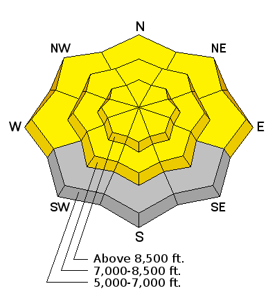
Heightened cornice fall and wind slab avalanche conditions exist today in drifted upper elevation terrain.
|
| type | aspect/elevation | characteristics |
|---|

|

|
LIKELIHOOD
LIKELY
UNLIKELY
SIZE
 LARGE
SMALL
TREND
 INCREASING DANGER
SAME
DECREASING DANGER
|
|
description
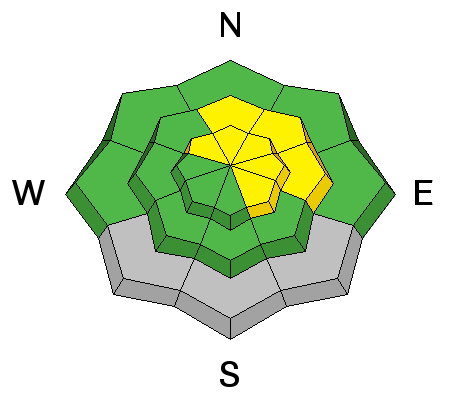
Powerful March sun and rapid warming today will quickly warm the new snow in sunny terrain, and the fresh snow will become moist and sticky and prone to avalanching. Avalanches starting as small point releases will entrain all the fresh snow in descent and could become quite sizable on long slopes with a sustained pitch. Natural loose wet avalanches are possible (and perhaps likely) on sunny slopes at all elevations during the heat of the day, and wet avalanches may become possible on shady low and mid elevation slopes as air temperatures skyrocket in the mountains.
|
 |
weather A warm southwest flow is developing over the region today and will increase through tomorrow. A weak system will cross over the zone on Saturday. A series of storms will begin to impact the region on Sunday and continue well into next week. Expect partly sunny weather today with southwest winds averaging in the mid teens along the ridges and a high temperature at 9000' around 48 degrees! It'll be partly cloudy tonight with a low around 34 degrees and a bit stronger southwest winds. It'll be partly cloudy again tomorrow with south southwest winds averaging in the mid twenties and mountain temperatures pushing 50 degrees again.
|
| general announcements Please submit snow and avalanche observations from your ventures in the backcountry HERE. You can call us at 801-524-5304 or email HERE, or include #utavy in your Instagram or Tweet us @UAClogan. To report avalanche activity in the Logan Area or to contact the local avalanche forecaster call me, Toby, at 435-757-7578. We'll update this advisory throughout the season on Monday, Wednesday, Friday, and Saturday mornings by about 7:30 This advisory is produced by the U.S.D.A. Forest Service, which is solely responsible for its content. It describes only general avalanche conditions and local variations always exist.
|


