| Please join us at the 23rd annual Black Diamond Fall Fundraiser Party Thursday Sept 15. Tickets are on sale now here, at the Black Diamond store & at REI. Special bonus raffle for online ticket purchasers! |
| Please join us at the 23rd annual Black Diamond Fall Fundraiser Party Thursday Sept 15. Tickets are on sale now here, at the Black Diamond store & at REI. Special bonus raffle for online ticket purchasers! |
| Advisory: Logan Area Mountains | Issued by Toby Weed for Monday - March 7, 2016 - 6:59am |
|---|

|
bottom line MODERATE (level 2): Heightened avalanche conditions exist and avalanches are possible on many slopes in the backcountry. You could trigger large cornice fall and/or wind slab avalanches in drifted upper elevation terrain. Some natural wet activity is possible with midday solar warming. Wet avalanches entraining significant moist new snow and gouging into saturated, rain and melt-softened old snow are possible at all elevations. Evaluate the snow and terrain carefully.
|
 |
current conditions It rained up above 8000' yesterday, and very wet snow accumulated up higher before the late afternoon cold front brought a drop in temperatures. A few inches of fresh "right-side-up" snow insulates saturated and slushy fresh snow from yesterday, which in some areas was apparently not bonding well with the old snow surface. The Tony Grove Snotel at 8400' reports 24 degrees this morning and 3 or 4 inches of new snow containing .6" of water in the last 24 hours. There's 71 inches of total snow containing 94% of average water for the date. It's 16 degrees and at the 9700' CSI Logan Peak weather station, with diminishing west winds yesterday and overnight. Looks like the wind sensor may be covered in rime this morning...
|
 |
recent activity
|
| type | aspect/elevation | characteristics |
|---|

|
|
LIKELIHOOD
 LIKELY
UNLIKELY
SIZE
 LARGE
SMALL
TREND
 INCREASING DANGER
SAME
DECREASING DANGER
|
|
description
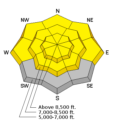
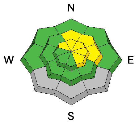
Heightened wind slab avalanche and cornice fall conditions exist in drifted upper elevation terrain.
|
| type | aspect/elevation | characteristics |
|---|

|
|
LIKELIHOOD
 LIKELY
UNLIKELY
SIZE
LARGE
SMALL
TREND
 INCREASING DANGER
SAME
DECREASING DANGER
|
|
description
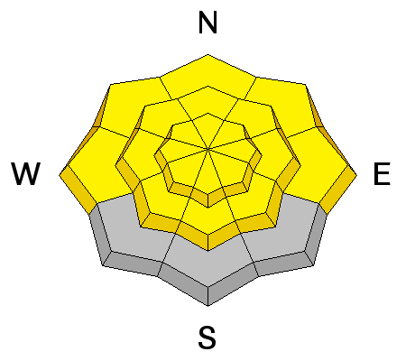
Temperatures dropped significantly overnight, and it should stay much cooler today, which will certainly help with the wet avalanche problem today. A few inches of fresh, lighter density snow from after frontal passage capped and will insulate very wet and even slushy snow from during the day yesterday at upper and mid elevations.
|
 |
weather High pressure will build over the region today, but the weather will remain active, and a couple weak systems will graze the zone in the next couple days. Snow showers are possible in the mountains this morning, but clearing and some sun is likely by afternoon. High temperatures at 8500' are expected to be just above freezing, and a moderate but sustained northwest wind will keep things cool and continue to drift yesterday's snow at upper elevations. It'll be partly cloudy tonight with a low around 23 degrees and lighter north wind. North, northeast winds are expected tomorrow morning, temperatures are expected to be a few degrees cooler, and there's a chance of snow showers in the afternoon. |
| general announcements Please submit snow and avalanche observations from your ventures in the backcountry HERE. You can call us at 801-524-5304 or email HERE, or include #utavy in your Instagram or Tweet us @UAClogan. To report avalanche activity in the Logan Area or to contact the local avalanche forecaster call me, Toby, at 435-757-7578. We'll update this advisory throughout the season on Monday, Wednesday, Friday, and Saturday mornings by about 7:30 This advisory is produced by the U.S.D.A. Forest Service, which is solely responsible for its content. It describes only general avalanche conditions and local variations always exist.
|


