| Please join us at the 23rd annual Black Diamond Fall Fundraiser Party Thursday Sept 15. Tickets are on sale now here, at the Black Diamond store & at REI. Special bonus raffle for online ticket purchasers! |
| Please join us at the 23rd annual Black Diamond Fall Fundraiser Party Thursday Sept 15. Tickets are on sale now here, at the Black Diamond store & at REI. Special bonus raffle for online ticket purchasers! |
| Advisory: Logan Area Mountains | Issued by Toby Weed for Saturday - March 5, 2016 - 6:48am |
|---|


|
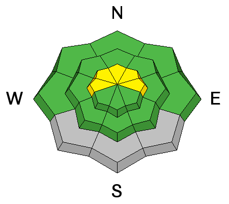
bottom line MODERATE (level 2): Heightened avalanche conditions exist at upper elevations in the northern portion of the Logan Zone, with triggered cornice falls and wind slab avalanches possible. After a couple nights without a good freeze, warm daytime temperatures could create the potential for wet avalanches on steep sheltered slopes with melt-softened snow. Evaluate the snow and terrain carefully.
|
 |
current conditions South winds intensified overnight and will continue to whistle along the ridges today. Conditions vary widely across the zone, with a few inches of dusty new snow accumulation and significant drifting in the north and reports of good spring "corn snow" in the past couple days in the mountains surrounding Cache Valley. The Tony Grove Snotel at 8400' reports 36 degrees this morning. There's 69 inches of total snow containing 93% of average water for the date. It's a toasty 36 degrees and south winds intensified overnight at the 9700' CSI Logan Peak weather station, currently showing 30 mph average wind speeds with gusts well into the 40s.
|
 |
recent activity
|
| type | aspect/elevation | characteristics |
|---|

|
|
LIKELIHOOD
 LIKELY
UNLIKELY
SIZE
 LARGE
SMALL
TREND
 INCREASING DANGER
SAME
DECREASING DANGER
|
|
description
Heightened wind slab avalanche and cornice fall conditions exist in some upper elevation terrain, mainly in the northern portion of the zone where more fresh snow accumulated this week.
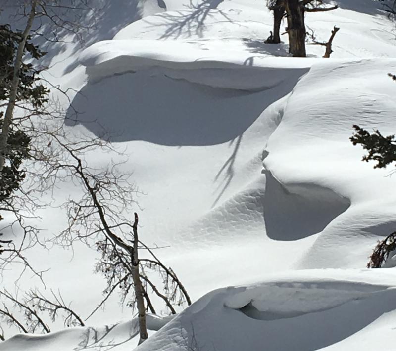
Sustained west winds drifted this week's fresh dust-infused accumulations, which were mainly limited to the northern part of the Logan Zone. Here's evidence of the drifting in exposed terrain, the backcountry on the south ridge of Beaver Mt. For you snow nerds and scientists, the new layer of dusty snow will be interesting to watch in the next couple weeks since it'll collect energy from solar radiation even after it's buried. (3-3-2016)
|
| type | aspect/elevation | characteristics |
|---|

|

|
LIKELIHOOD
LIKELY
UNLIKELY
SIZE
LARGE
SMALL
TREND
INCREASING DANGER
SAME
DECREASING DANGER
|
|
description
Clouds and wind will probably keep the snow from softening too much, but temperatures remained well above freezing in the mountains again overnight. Despite the clouds, daytime temperatures will be quite warm and wet avalanches may become possible on sheltered slopes where the saturated snow gets soft and slushy.
|
 |
weather Expect cloudy conditions today with a high temperature at 8500' around 47 degrees, possible snow showers, and 15 mph+ southwest winds. It'll be mostly cloudy tonight with low temperatures around 37, increasing and strong south wind, and a good chance of snow showers after midnight. It'll snow tomorrow and some thunder is also possible. Expect a windy storm with dropping temperatures, strong southwest--west--northwest winds, and 5 to 9 inches of accumulation by evening. Snowfall and winds should continue though Sunday night.
|
| general announcements Please submit snow and avalanche observations from your ventures in the backcountry HERE. You can call us at 801-524-5304 or email HERE, or include #utavy in your Instagram or Tweet us @UAClogan. To report avalanche activity in the Logan Area or to contact the local avalanche forecaster call me, Toby, at 435-757-7578. We'll update this advisory throughout the season on Monday, Wednesday, Friday, and Saturday mornings by about 7:30 This advisory is produced by the U.S.D.A. Forest Service, which is solely responsible for its content. It describes only general avalanche conditions and local variations always exist.
|