| Please join us at the 23rd annual Black Diamond Fall Fundraiser Party Thursday Sept 15. Tickets are on sale now here, at the Black Diamond store & at REI. Special bonus raffle for online ticket purchasers! |
| Please join us at the 23rd annual Black Diamond Fall Fundraiser Party Thursday Sept 15. Tickets are on sale now here, at the Black Diamond store & at REI. Special bonus raffle for online ticket purchasers! |
| Advisory: Logan Area Mountains | Issued by Toby Weed for Thursday - March 3, 2016 - 7:31am |
|---|

|
bottom line MODERATE (level 2): The snow is stable on most slopes and avalanches are generally unlikely. However, heightened avalanche conditions exist at upper elevations in the north portion of the zone, with human triggered wind slab avalanches and cornice-falls possible. Midday loose wet avalanches may also become possible as the snow softens on sunny slopes. Evaluate the snow and terrain carefully.
|
 |
current conditions The Tony Grove Snotel at 8400' reports 34 degrees this morning, and there's 72 inches of total snow now containing 93% of average water for the date. It's a balmy 31 degrees and still pretty windy at the 9700' CSI Logan Peak weather station, currently showing 25 mph (average) southwest winds. Sustained and gusty southwest winds have been ongoing in the mountains for a while including yesterday and overnight, and exposed slopes are obviously a bit wind-jacked. Stashes of soft recrystallized snow exist on some high sheltered north facing slopes, and the snow on sunny slopes should soften pretty early today with fairly warm overnight temperatures and developing sunny conditions.
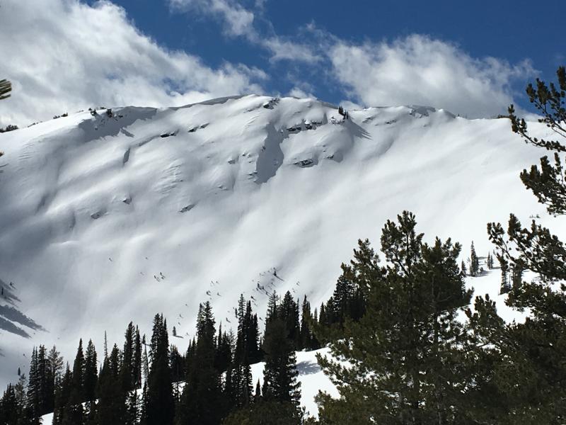
We chose to avoid recently drifted upper elevation slopes yesterday, like this one on the east face of Wilderness Peak in the Gibson Lakes Area out of Franklin Basin in Southeast Idaho. (3-2-2016)
|
 |
recent activity
|
| type | aspect/elevation | characteristics |
|---|

|

|
LIKELIHOOD
 LIKELY
UNLIKELY
SIZE
 LARGE
SMALL
TREND
 INCREASING DANGER
SAME
DECREASING DANGER
|
|
description
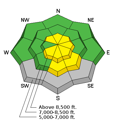
Heightened wind slab avalanche and cornice fall conditions exist in some upper elevation terrain, mainly in the northern portion of the zone where more fresh snow accumulated recently.
|
| type | aspect/elevation | characteristics |
|---|

|
|
LIKELIHOOD
LIKELY
UNLIKELY
SIZE
 LARGE
SMALL
TREND
 INCREASING DANGER
SAME
DECREASING DANGER
|
|
description
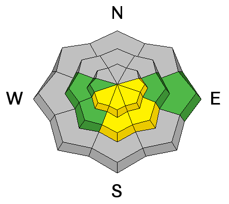
Temperatures remained above freezing at most stations overnight. Loose wet avalanches may become possible on slopes where saturated snow is softened by solar warmth. In most areas, there is not enough fresh snow for this to be much of a problem, but sluffs entraining a few inches of warming moist new snow are certainly possible at upper elevations. The snow lower down has been through numerous melt-freeze cycles, the round snow grains are fairly large, and avalanches are pretty unlikely even when the snow surface is softened by the midday warmth. Exceptions might be found on steep slopes in shallow or rocky areas with very soft or weak wet snow.
|
 |
weather HIGH PRESSURE ALOFT WILL REMAIN ACROSS THE GREAT BASIN THROUGH FRIDAY NIGHT. A MILD SOUTHWESTERLY FLOW WILL FOLLOW THIS WEEKEND AHEAD OF A MOIST PACIFIC STORM SYSTEM WHICH WILL IMPACT UTAH SUNDAY INTO EARLY NEXT WEEK.
|
| general announcements Please submit snow and avalanche observations from your ventures in the backcountry HERE. You can call us at 801-524-5304 or email HERE, or include #utavy in your Instagram or Tweet us @UAClogan. To report avalanche activity in the Logan Area or to contact the local avalanche forecaster call me, Toby, at 435-757-7578. We'll update this advisory throughout the season on Monday, Wednesday, Friday, and Saturday mornings by about 7:30 This advisory is produced by the U.S.D.A. Forest Service, which is solely responsible for its content. It describes only general avalanche conditions and local variations always exist.
|