| Please join us at the 23rd annual Black Diamond Fall Fundraiser Party Thursday Sept 15. Tickets are on sale now here, at the Black Diamond store & at REI. Special bonus raffle for online ticket purchasers! |
| Please join us at the 23rd annual Black Diamond Fall Fundraiser Party Thursday Sept 15. Tickets are on sale now here, at the Black Diamond store & at REI. Special bonus raffle for online ticket purchasers! |
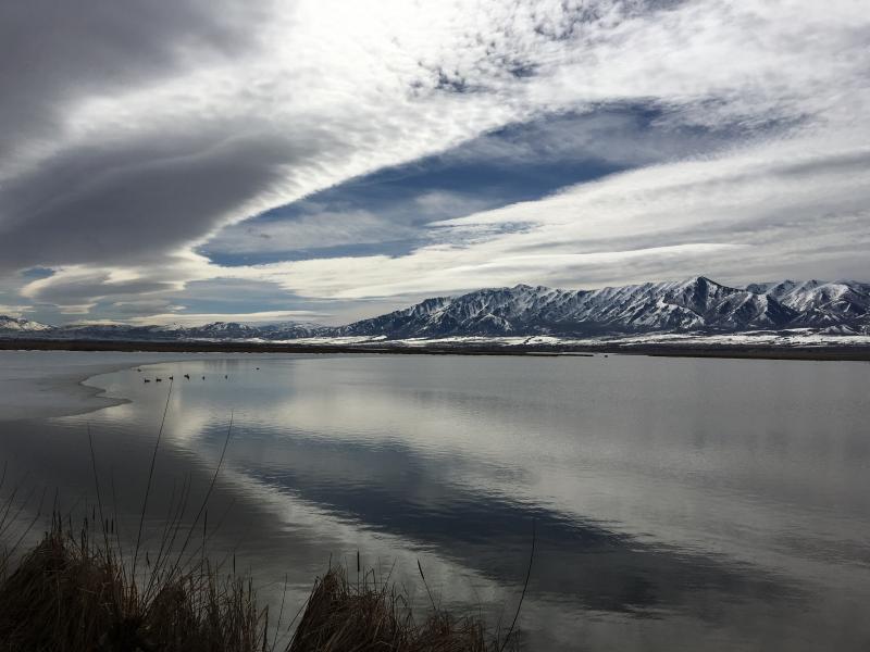
| Advisory: Logan Area Mountains | Issued by Toby Weed for Wednesday - March 2, 2016 - 7:01am |
|---|

|
bottom line LOW (level 1): The snow is quite stable on most slopes in the backcountry and avalanches are generally unlikely. Exceptions might include possible triggered cornice falls and/or wind slab avalanches in drifted upper elevation terrain and midday loose wet avalanches as the snow softens on sunny slopes. Use normal caution.
|
 |
current conditions The Tony Grove Snotel at 8400' reports an other inch of accumulation overnight and it's 34 degrees this morning. There's 72 inches of total snow now containing 94% of average water for the date. It's 23 degrees and pretty windy at the 9700' CSI Logan Peak weather station, currently showing 22 mph (average) west-southwest winds. Sustained and gusty southwest winds have been ongoing in the mountains for a while including yesterday and overnight, and exposed slopes are obviously a bit wind-jacked. Stashes of soft recrystallized snow exist on some high sheltered north facing slopes, and the snow on sunny slopes should soften pretty early today with fairly warm overnight temperatures and developing sunny conditions.
Clouds kept a lid on the meltdown and helped to keep the lower elevation snow from softening too much yesterday (3-1-2016). Snow and ice are rapidly melting away in the valley and on sunny lower elevation slopes, but coverage is actually still pretty good in the mountains.
|
 |
recent activity
|
| type | aspect/elevation | characteristics |
|---|

|
|
LIKELIHOOD
 LIKELY
UNLIKELY
SIZE
 LARGE
SMALL
TREND
 INCREASING DANGER
SAME
DECREASING DANGER
|
|
description
Heightened wind slab avalanche and cornice fall conditions may exist in some upper elevation terrain.
|
| type | aspect/elevation | characteristics |
|---|

|
|
LIKELIHOOD
 LIKELY
UNLIKELY
SIZE
 LARGE
SMALL
TREND
 INCREASING DANGER
SAME
DECREASING DANGER
|
|
description
Loose wet avalanches may become possible on slopes where saturated snow is softened by solar warmth. There is not enough fresh snow for this to be much of a problem, but sluffs entraining a few inches of warming moist new snow are certainly possible at upper elevations. The snow lower down has been through numerous melt-freeze cycles, the round snow grains are fairly large, and avalanches are pretty unlikely even when the snow surface is softened by the midday warmth. Exceptions might be found on steep slopes in shallow or rocky areas with very soft or weak wet snow.
|
 |
weather Snow showers are possible this morning, but we can expect clearing and mostly sunny conditions in the mountains today with a high at 8500' climbing to around 42 degrees. It'll be breezy, with 20 to 25 mph west winds on the ridges and gusts in the 40s. It'll be partly cloudy tonight, with a low around 28 degrees and gradually decreasing northwest wind. It'll be mostly sunny tomorrow, with high temperature around 48 degrees. High pressure conditions will prevail on Thursday, but a mild southwesterly flow will develop on Friday ahead of a moist Pacific Storm system headed our way for late in the weekend.
|
| general announcements Please submit snow and avalanche observations from your ventures in the backcountry HERE. You can call us at 801-524-5304 or email HERE, or include #utavy in your Instagram or Tweet us @UAClogan. To report avalanche activity in the Logan Area or to contact the local avalanche forecaster call me, Toby, at 435-757-7578. We'll update this advisory throughout the season on Monday, Wednesday, Friday, and Saturday mornings by about 7:30 This advisory is produced by the U.S.D.A. Forest Service, which is solely responsible for its content. It describes only general avalanche conditions and local variations always exist.
|