| Please join us at the 23rd annual Black Diamond Fall Fundraiser Party Thursday Sept 15. Tickets are on sale now here, at the Black Diamond store & at REI. Special bonus raffle for online ticket purchasers! |
| Please join us at the 23rd annual Black Diamond Fall Fundraiser Party Thursday Sept 15. Tickets are on sale now here, at the Black Diamond store & at REI. Special bonus raffle for online ticket purchasers! |
| Advisory: Logan Area Mountains | Issued by Toby Weed for Monday - February 29, 2016 - 6:28am |
|---|

|
bottom line LOW (level 1): The snow is quite stable on most slopes in the backcountry, but areas with heightened wind slab conditions may develop at upper elevations with today's weather. Use normal caution, but watch for and avoid growing cornices and fresh deposits of drifted snow on steep slopes.
|
 |
current conditions The Tony Grove Snotel at 8400' reports 30 degrees this morning, and there's 71 inches of total snow now containing 94% of average water for the date. It's 23 degrees at the 9700' CSI Logan Peak weather station, showing 15 mph west winds. It's getting harder to find areas with soft recrystallized snow and the "pow" seems limmitted to sheltered north facing terrain. I found pretty good smooth fast spring-like riding conditions yesterday afternoon in the sun on slopes with a softened surface on otherwise supportable snow.
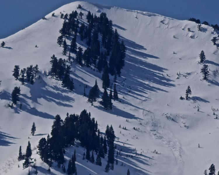
Veiws from the Mendon Area on 2-28-16 of recent cornice-fall activity on east facing slopes in the Wellsville Range. |
 |
recent activity
|
| type | aspect/elevation | characteristics |
|---|

|
|
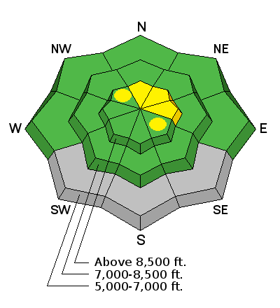
LIKELIHOOD
 LIKELY
UNLIKELY
SIZE
 LARGE
SMALL
TREND
 INCREASING DANGER
SAME
DECREASING DANGER
|
|
description
There's not much in the way of transportable snow on the surface these days, but some new accumulation is possible and heightened wind slab avalanche and cornice fall conditions may develop with today's weather in some upper elevation terrain.
|
 |
weather Snow showers are likely in the mountains this morning and we can expect mostly cloudy conditions with a high at 8500' around 34 degrees. It'll be breezy, with 20 to 25 mph west winds on the ridges. Less than an inch of accumulation is expected. It'll be partly cloudy tonight, with a low around 19 degrees and a gradually decreasing northwest wind. It'll be partly sunny tomorrow, with high temperature around 38 degrees. The next round of unsettled weather is expected Tuesday night and Wednesday, with snow showers but again little in the way of accumulation. High pressure conditions will then build and remain over the region for the remainder of the week.
|
| general announcements Please submit snow and avalanche observations from your ventures in the backcountry HERE. You can call us at 801-524-5304 or email HERE, or include #utavy in your Instagram or Tweet us @UAClogan. To report avalanche activity in the Logan Area or to contact the local avalanche forecaster call me, Toby, at 435-757-7578. We'll update this advisory throughout the season on Monday, Wednesday, Friday, and Saturday mornings by about 7:30 This advisory is produced by the U.S.D.A. Forest Service, which is solely responsible for its content. It describes only general avalanche conditions and local variations always exist.
|