| Please join us at the 23rd annual Black Diamond Fall Fundraiser Party Thursday Sept 15. Tickets are on sale now here, at the Black Diamond store & at REI. Special bonus raffle for online ticket purchasers! |
| Please join us at the 23rd annual Black Diamond Fall Fundraiser Party Thursday Sept 15. Tickets are on sale now here, at the Black Diamond store & at REI. Special bonus raffle for online ticket purchasers! |
| Advisory: Logan Area Mountains | Issued by Toby Weed for Sunday - February 28, 2016 - 7:00am |
|---|

|
bottom line MODERATE (level 2): The snow is mostly stable in the backcountry, but areas with heightened wind slab avalanche conditions exist in some drifted terrain. Use normal caution, and evaluate the snow and terrain carefully, especially on steep wind drifted slopes at upper elevations.
|
 |
current conditions The Tony Grove Snotel at 8400' reports 24 degrees this morning, and there's an inch of new snow, with 72 inches of total snow now containing 95% of average water for the date. It's 19 degrees at the 9700' CSI Logan Peak weather station, showing 15 mph northwest winds. We've found good snow stability and a low avalanche danger this week, but drifting from yesterday's wind created pockets with heightened danger of wind slab avalanches at upper elevations in areas with soft transportable surface snow. |
 |
recent activity
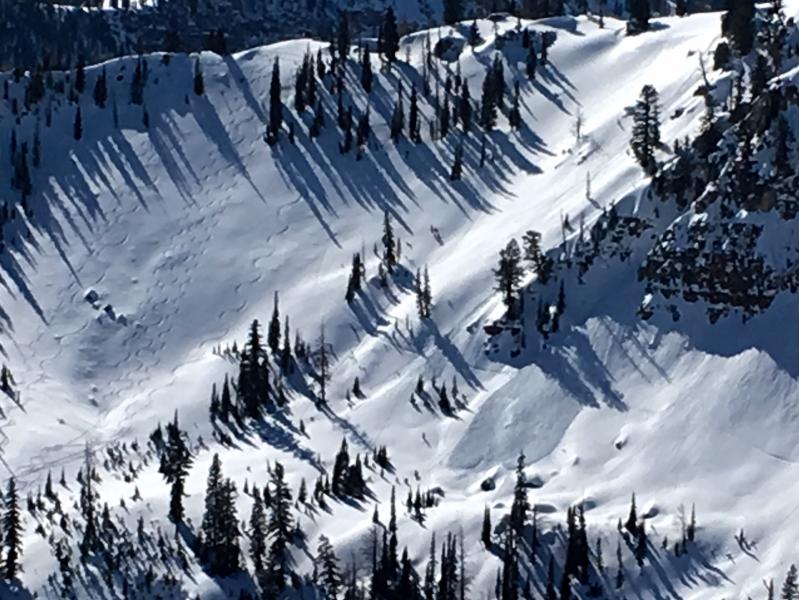
A natural loose wet avalanche occurred midday Friday (2-26-16) on a steep east facing slope in Steam Mill Canyon.
***To view our updated list of backcountry observations and avalanche activity from around Utah, go to our observations page
|
| type | aspect/elevation | characteristics |
|---|

|
|
LIKELIHOOD
 LIKELY
UNLIKELY
SIZE
 LARGE
SMALL
TREND
 INCREASING DANGER
SAME
DECREASING DANGER
|
|
description
Heightened wind slab avalanche conditions exist on some steep upper elevation slopes.
Observers triggered a handful of small soft wind slabs in the Franklin Basin Area Friday. (Flygare 2-26-16) |
 |
weather Today: Mostly cloudy, with a high near 38. West wind 8 to 14 mph. |
| general announcements Please submit snow and avalanche observations from your ventures in the backcountry HERE. You can call us at 801-524-5304 or email HERE, or include #utavy in your Instagram or Tweet us @UAClogan. To report avalanche activity in the Logan Area or to contact the local avalanche forecaster call me, Toby, at 435-757-7578. We'll update this advisory throughout the season on Monday, Wednesday, Friday, and Saturday mornings by about 7:30 This advisory is produced by the U.S.D.A. Forest Service, which is solely responsible for its content. It describes only general avalanche conditions and local variations always exist.
|