| Please join us at the 23rd annual Black Diamond Fall Fundraiser Party Thursday Sept 15. Tickets are on sale now here, at the Black Diamond store & at REI. Special bonus raffle for online ticket purchasers! |
| Please join us at the 23rd annual Black Diamond Fall Fundraiser Party Thursday Sept 15. Tickets are on sale now here, at the Black Diamond store & at REI. Special bonus raffle for online ticket purchasers! |
| Advisory: Logan Area Mountains | Issued by Toby Weed for Saturday - February 27, 2016 - 7:32am |
|---|

|
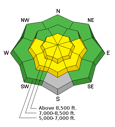
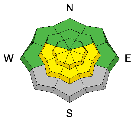
bottom line MODERATE (level 2): The snow is mostly stable in the backcountry, but drifting from intensifying southwest winds today may create heightened avalanche conditions on some upper elevation slopes. Solar heating and warm daytime temperatures may cause heightened wet avalanche conditions to develop on steep sunny slopes with saturated melt-softened snow. Use normal caution, but evaluate the snow and terrain carefully and avoid steep slopes with drifted or melt saturated snow.
|
 |
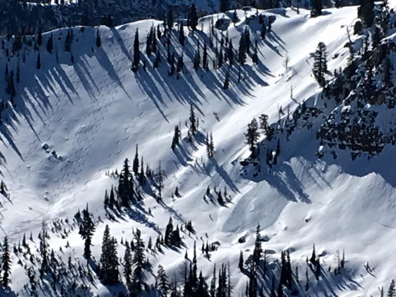
current conditions The Tony Grove Snotel at 8400' reports no overnight freeze and a toasty 40 degrees this morning and there's 72 inches of total snow, now containing 95% of average water for the date. It's 32 degrees at the 9700' CSI Logan Peak weather station, and southwest winds intenisifyed overnight, showing a current average wind speed of 26 mph with gusts to 35 mph this morning. Shallow settled powder riding conditions are still quite good in north facing terrain. We've found good snow stability and a low avalanche danger this week, but drifting from strengthening southwest wind will probably create heightened danger of wind slab avalanches at upper elevations in areas with soft transportable surface snow. Temperatures stayed warm overnight, but clouds and wind should help keep the snow cool today. Even so, solar heating might be enhanced by greenhousing in sheltered terrain and heightened wet avalanche conditions may develop again with midday warmth on some sunny slopes with saturated snow. |
 |
recent activity
***To view our updated list of backcountry observations and avalanche activity from around Utah, go to our observations page
|
| type | aspect/elevation | characteristics |
|---|

|

|
LIKELIHOOD
 LIKELY
UNLIKELY
SIZE
 LARGE
SMALL
TREND
 INCREASING DANGER
SAME
DECREASING DANGER
|
|
description
Drifting of existing soft snow by intensifying southwest and westerly winds today may create heightened wind slab avalanche conditions on some steep upper elevation slopes.
Observers triggered a handful of small soft wind slabs in the Franklin Basin Area Friday. (Flygare 2-26-16) |
| type | aspect/elevation | characteristics |
|---|

|
|
LIKELIHOOD
LIKELY
UNLIKELY
SIZE
LARGE
SMALL
TREND
INCREASING DANGER
SAME
DECREASING DANGER
|
|
description
Cloud cover and wind should keep the snow from heating up too much today, but the high-angled late February sun and potential greenhousing could allow for warm surface temperatures in sheltered terrain. Overnight temperatures stayed well above freezing in many areas, and heightened wet avalanche conditions may develop again during the heat of the day on sunny slopes as wet surface snow softens. Roller balls and natural surface sluffing are red flags to wet avalanche instability. Avoid midday or afternoon travel on or below steep sunny slopes with warmth softened saturated snow.
A natural loose wet avalanche occurred midday Friday (2-26-16) observed on a steep east facing slope in the Boiler Bowl Area.
|
 |
weather Today: Snow showers likely, mainly after noon. Some thunder is also possible. Cloudy, with a high near 40. Windy, with a west southwest wind 15 to 20 mph increasing to 25 to 30 mph in the afternoon. Winds could gust as high as 44 mph. Chance of precipitation is 60%. Total daytime snow accumulation of less than one inch possible.
|
| general announcements Please submit snow and avalanche observations from your ventures in the backcountry HERE. You can call us at 801-524-5304 or email HERE, or include #utavy in your Instagram or Tweet us @UAClogan. To report avalanche activity in the Logan Area or to contact the local avalanche forecaster call me, Toby, at 435-757-7578. We'll update this advisory throughout the season on Monday, Wednesday, Friday, and Saturday mornings by about 7:30 This advisory is produced by the U.S.D.A. Forest Service, which is solely responsible for its content. It describes only general avalanche conditions and local variations always exist.
|