| Please join us at the 23rd annual Black Diamond Fall Fundraiser Party Thursday Sept 15. Tickets are on sale now here, at the Black Diamond store & at REI. Special bonus raffle for online ticket purchasers! |
| Please join us at the 23rd annual Black Diamond Fall Fundraiser Party Thursday Sept 15. Tickets are on sale now here, at the Black Diamond store & at REI. Special bonus raffle for online ticket purchasers! |
| Advisory: Logan Area Mountains | Issued by Toby Weed for Wednesday - February 24, 2016 - 7:06am |
|---|

|
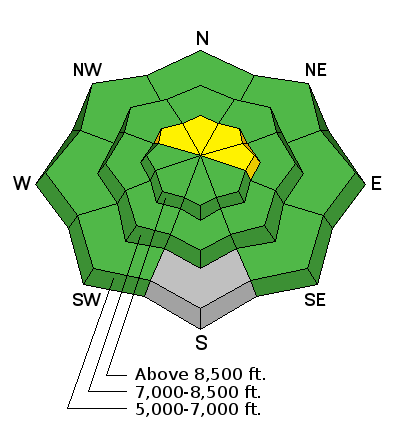
bottom line LOW (level 1): The snow stability is good on most slopes in the Logan Zone, and avalanches are generally unlikely in the backcountry. Drifting from southwest wind this morning may create pockets with heightened wind slab avalanche conditions at upper elevations. Use normal caution. Carry and practice with your companion avalanche rescue gear and continue to practice wise backcountry travel protocols.
|
 |
special announcement We are offering an Avalanche Awareness for Snowmobilers Course on February 25 & 27. For more information and to register go..... HERE
|
 |
current conditions The Tony Grove Snotel at 8400' reports 21 degrees and there's 77 inches of total snow containing 98% of average water for the date. I'm reading 13 degrees at the 9700' CSI Logan Peak weather station, and southwest winds averaging a bit over 30 mph this morning. Snow stability is generally good in the backcountry, the overall danger is low, and avalanches are unlikely. Today's southwest winds may cause a bit of drifting, and you might be able to trigger small fresh or recently formed wind slabs in some exposed upper elevation areas.
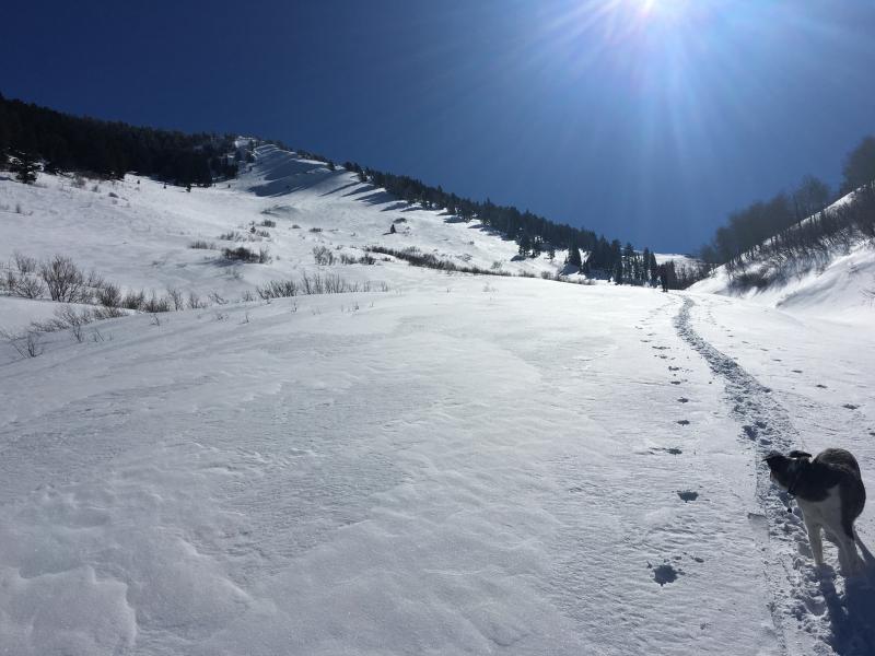
Maintaining some spacing while working our way under the north side of Mendon Peak in the Wellsville Mountain Wilderness...(2-23-16)
|
 |
recent activity
|
| type | aspect/elevation | characteristics |
|---|

|
|
LIKELIHOOD
 LIKELY
UNLIKELY
SIZE
 LARGE
SMALL
TREND
 INCREASING DANGER
SAME
DECREASING DANGER
|
|
description
Low danger does not mean No danger, and unlikely implies that avalanches are still possible. There are several types of avalanche problems you may run into today. Most of these are of the manageable variety and probably do not pose much threat, but "use normal caution" suggests that you still evaluate the snow and terrain carefully, carry and know how to use all the proper avalanche rescue equipment, and continue to practice wise backcountry travel protocols.
|
| type | aspect/elevation | characteristics |
|---|

|
|
LIKELIHOOD
 LIKELY
UNLIKELY
SIZE
 LARGE
SMALL
TREND
 INCREASING DANGER
SAME
DECREASING DANGER
|
|
description
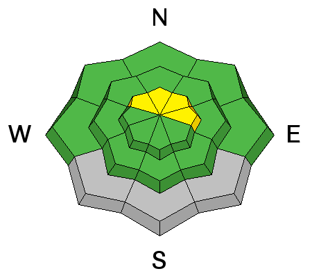
Pockets with heightened wind slab and/or cornice fall conditions may exist in some upper elevation areas.
|
 |
weather It'll be partly sunny in the mountains today, with 8500' high temperatures around 33 degrees and west winds in the 15 mph range. It'll be partly cloudy tonight with a low temperature around 20 degrees and lighter west winds. Expect mostly sunny conditions tomorrow with high temperatures around 37 degrees and continuing moderate west wind. High pressure conditions will remain in place over the region through the work week, and our next chance for a little snow arrives this weekend. |
| general announcements Please submit snow and avalanche observations from your ventures in the backcountry HERE. You can call us at 801-524-5304 or email HERE, or include #utavy in your Instagram or Tweet us @UAClogan. To report avalanche activity in the Logan Area or to contact the local avalanche forecaster call me, Toby, at 435-757-7578. We'll update this advisory throughout the season on Monday, Wednesday, Friday, and Saturday mornings by about 7:30 This advisory is produced by the U.S.D.A. Forest Service, which is solely responsible for its content. It describes only general avalanche conditions and local variations always exist.
Backcountry Responsibility Objective from Trent Meisenheimer on Vimeo. |