| Please join us at the 23rd annual Black Diamond Fall Fundraiser Party Thursday Sept 15. Tickets are on sale now here, at the Black Diamond store & at REI. Special bonus raffle for online ticket purchasers! |
| Please join us at the 23rd annual Black Diamond Fall Fundraiser Party Thursday Sept 15. Tickets are on sale now here, at the Black Diamond store & at REI. Special bonus raffle for online ticket purchasers! |
| Advisory: Logan Area Mountains | Issued by Toby Weed for Monday - February 22, 2016 - 6:44am |
|---|

|
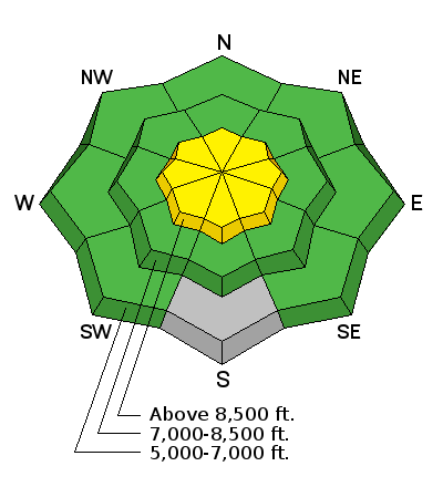
bottom line LOW (level 1): In most areas across the Logan Zone this morning the snow stability is good and avalanches are generally unlikely. Drifting from easterly winds this morning will probably create areas with heightened avalanche conditions at upper elevations. Dangerous persistent or deep slab avalanches are unlikely yet remain possible in drifted outlying or isolated terrain with thin snow cover and poor snow structure. Use normal caution, evaluate the snow and terrain carefully at upper elevations this afternoon, and avoid fresh wind drifts on steep slopes.
|
 |
special announcement We are offering an Avalanche Awareness for Snowmobilers Course on February 25 & 27. For more information and to register go..... HERE
|
 |
current conditions The Tony Grove Snotel at 8400' reports 26 degrees and there's 77 inches of total snow containing 100% of average water for the date. I'm reading 19 degrees at the 9700' CSI Logan Peak weather station, and northwest winds averaging 15 mph this morning. Snow stability is generally good in the backcountry this morning, the overall danger is low, and avalanches are unlikely. A weather disturbance crossing through the region today will bring some snow, and perhaps a bit of thunder, with 1 to 3 inches of accumulation forecast. Northwest winds will cause a bit of drifting, and heightened wind slab conditions will probably develop on some upper elevation slopes by mid afternoon.
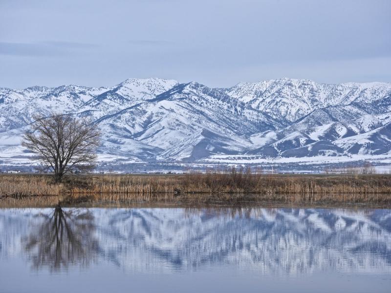
Calm conditions in Cache Valley. Naomi Peak above the Little Bear River (2-19-16)
|
 |
recent activity
|
| type | aspect/elevation | characteristics |
|---|

|
|
LIKELIHOOD
 LIKELY
UNLIKELY
SIZE
 LARGE
SMALL
TREND
 INCREASING DANGER
SAME
DECREASING DANGER
|
|
description
Low danger does not mean No danger, and unlikely implies that avalanches are still possible. There are several types of avalanche problems you may run into today. Most of these are of the manageable variety and probably do not pose much threat, but "use normal caution" suggests that you still evaluate the snow and terrain carefully, carry and know how to use all the proper avalanche rescue equipment, and continue to practice wise backcountry travel protocols.
|
| type | aspect/elevation | characteristics |
|---|

|
|
LIKELIHOOD
 LIKELY
UNLIKELY
SIZE
LARGE
SMALL
TREND
INCREASING DANGER
SAME
DECREASING DANGER
|
|
description
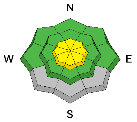
2-23-16 AM update: A bump in east winds this morning may drift snow into rather unexpected areas, and there are probably areas at upper elevations with heightened wind slab conditions. The fresh wind slabs will probably be rather soft and manageable in nature, but you should be wary and especially cautious on steep slopes above trees or other terrain traps.
|
 |
weather A Pacific disturbance moving through the region will bring snow and a chance of thunder today. Expect 8500' high temperatures around 28 degrees and northwest winds in the 15 to 20 mph range. 1 to 3 inches of accumulation is expected by evening. Snow showers will continue tonight, with an additional 1 or 2 inches of snowfall likely, continuing northwest wind and temperatures falling to around 14 degrees. Snow showers are possible tomorrow, but little is expected in the way of accumulations, then mostly sunny conditions will develop, with a high temperature around 27 degrees, and moderate north-northwest wind. High pressure conditions will build into the region midweek... |
| general announcements Please submit snow and avalanche observations from your ventures in the backcountry HERE. You can call us at 801-524-5304 or email HERE, or include #utavy in your Instagram or Tweet us @UAClogan. To report avalanche activity in the Logan Area or to contact the local avalanche forecaster call me, Toby, at 435-757-7578. We'll update this advisory throughout the season on Monday, Wednesday, Friday, and Saturday mornings by about 7:30 This advisory is produced by the U.S.D.A. Forest Service, which is solely responsible for its content. It describes only general avalanche conditions and local variations always exist.
Backcountry Responsibility Objective from Trent Meisenheimer on Vimeo. |