| Please join us at the 23rd annual Black Diamond Fall Fundraiser Party Thursday Sept 15. Tickets are on sale now here, at the Black Diamond store & at REI. Special bonus raffle for online ticket purchasers! |
| Please join us at the 23rd annual Black Diamond Fall Fundraiser Party Thursday Sept 15. Tickets are on sale now here, at the Black Diamond store & at REI. Special bonus raffle for online ticket purchasers! |
| Advisory: Logan Area Mountains | Issued by Toby Weed for Saturday - February 20, 2016 - 6:21am |
|---|

|
bottom line MODERATE (level 2): Heightened avalanche conditions exist, and triggered wind slab avalanches are possible on drifted upper and mid elevation slopes steeper than about 30 degrees. Dangerous persistent or deep slab avalanches are unlikely yet remain possible in drifted outlying or isolated terrain with thin snow cover and poor snow structure. Evaluate the snow and terrain carefully, and avoid stiffer wind deposited snow on steep slopes. 0900 Update: More than expected accumulations of heavy snow this morning in the Logan Zone will cause heightened avalanche conditions on steep slopes with significant accumulations of heavy new snow at all elevations.
|
 |
special announcement We are offering an Avalanche Awareness for Snowmobilers Course on February 25 & 27. For more information and to register go..... HERE
|
 |
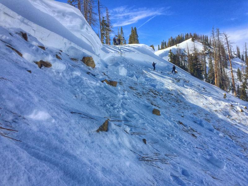
current conditions The Tony Grove Snotel at 8400' recorded around 8 inches of new snow with 1.1" of water from Thursday's storm. It's currently 31 degrees and there's 76 inches of total snow containing 102% of average water for the date. I'm reading 22 degrees at the 9700' CSI Logan Peak weather station, and west winds averaging 15 mph this morning. Riding conditions are greatly improved especially compaired to earlier in the week, but strong and sustained south and west winds have damaged the snow surface in exposed terrain. Drifting created heightend wind slab avalanche conditions on exposed slopes at upper elevations.. The lower elevation snow is set up and much more stable thanks to a couple nights with below freezing temperatures.
|
 |
recent activity
|
| type | aspect/elevation | characteristics |
|---|

|
|
LIKELIHOOD
 LIKELY
UNLIKELY
SIZE
 LARGE
SMALL
TREND
 INCREASING DANGER
SAME
DECREASING DANGER
|
|
description
Very strong winds Thursday and yesterday drifted the new snow into avalanche starting zones at upper elevations, and you could trigger wind slab avalanches up to around 2 feet deep on some steep drifted slopes. Expect to find new drifts and wind slabs well off major ridge lines and perhaps in rather unexpected places.
|
| type | aspect/elevation | characteristics |
|---|

|
|
LIKELIHOOD
 LIKELY
UNLIKELY
SIZE
 LARGE
SMALL
TREND
 INCREASING DANGER
SAME
DECREASING DANGER
|
|
description
Persistent and/or deep slab avalanches are unlikely yet still possible on drifted slopes in outlying areas with shallow weak snow. Avoid slopes with poor snow structure and recent accumulations of drifted snow.. You'll have to dig into the snow to find out if there's weak sugary or faceted snow near the ground under a heavier or harder layer. (or a slab) It's been a couple weeks now since the last reported persistent or deep slab avalanche involving older snow in the Logan Zone, but there may be a few rogue slopes out there where you might trigger a dangerous avalanche. Be cautious where the snowpack is shallow or thin and the snow is weak. Wind-swept rocky slopes at upper and mid elevations are suspect, as are slopes that avalanched earlier in the winter.
Another close call! A lucky rider triggered and then managed to escape this large and dangerous deep slab avalanche yesterday on the Skyline. There may still be outlying slopes in the Logan Zone where this type of avalanche is possible. (2-19-16) View Report
|
| type | aspect/elevation | characteristics |
|---|

|
|
LIKELIHOOD
 LIKELY
UNLIKELY
SIZE
 LARGE
SMALL
TREND
 INCREASING DANGER
SAME
DECREASING DANGER
|
|
description
Heightened avalanche conditions exist on steep slopes with significant accumulations of heavy new snow at all elevations. Shallow soft slab and loose snow avalanches involving the fresh new snow are possible. Periods of sun and warming could cause the new snow on sunny slopes and at lower elevations to become moist, sticky, and prone to sluffing. Moist sluffs could entrain significant piles of new snow at especially on long steep slopes. |
 |
weather This morning's snow showers will taper off before noon and not much in the way of accumulation is expected. Expect gradual clearing this afternoon, with sky conditions becoming partly sunny. High temperatures at 8500' are expected to be around 33 degrees, and we'll see west winds averaging 10 to 15 mph in the mountains. It'll be partly cloudy tonight with a low temperature around 19 degrees and continuing but diminishing west winds. Expect mostly sunny conditions tomorrow, with a high temperature around 34 degrees, and moderate west-southwest wind. |
| general announcements Please submit snow and avalanche observations from your ventures in the backcountry HERE. You can call us at 801-524-5304 or email HERE, or include #utavy in your Instagram or Tweet us @UAClogan. To report avalanche activity in the Logan Area or to contact the local avalanche forecaster call me, Toby, at 435-757-7578. We'll update this advisory throughout the season on Monday, Wednesday, Friday, and Saturday mornings by about 7:30 This advisory is produced by the U.S.D.A. Forest Service, which is solely responsible for its content. It describes only general avalanche conditions and local variations always exist. Backcountry Responsibility Objective from Trent Meisenheimer on Vimeo. |