| Please join us at the 23rd annual Black Diamond Fall Fundraiser Party Thursday Sept 15. Tickets are on sale now here, at the Black Diamond store & at REI. Special bonus raffle for online ticket purchasers! |
| Please join us at the 23rd annual Black Diamond Fall Fundraiser Party Thursday Sept 15. Tickets are on sale now here, at the Black Diamond store & at REI. Special bonus raffle for online ticket purchasers! |
| Advisory: Logan Area Mountains | Issued by Toby Weed for Friday - February 19, 2016 - 6:15am |
|---|

|
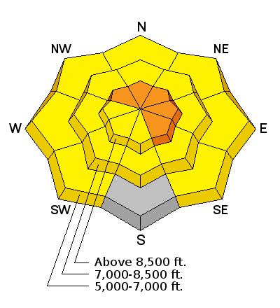
bottom line CONSIDERABLE (level 3): Dangerous avalanche conditions probably exist, and triggered wind slab avalanches are likely today on some drifted upper elevation slopes. Heightened conditions exist on many other slopes in the backcountry, with triggered wind slab, storm snow, and loose wet avalanches all possible on slopes steeper than about 30 degrees. Evaluate the snow and terrain carefully, and avoid travel on or below steep drifted slopes.
|
 |
special announcement We are offering an Avalanche Awareness for Snowmobilers Course on February 25 & 27. For more information and to register go..... HERE
|
 |
current conditions We'll find greatly improved riding conditions in the backcountry today with a good shot of new snow across the zone yesterday and overnight. Yesterday, heavy and drifting snow was sticking pretty well to the crusty surface snow and softening the ride significantly. I'm not sure how much snow we picked up across the zone, since the Snotel system is down, but there's 12 inches of new snow in the last 24 hours on Beaver Mt. Beaver is reporting 68 inches of total snow, and 20 degrees at the top of the mountain. I'm reading 16 degrees at the 9700' CSI Logan Peak weather station, and west winds averaging 15 to 20 mph this morning. The station recorded very strong and sustained wind from the south-southwest for several hours yesterday morning, with average wind speeds in excess of 40 mph and gusts nearing 80 mph. Dangerous avalanche conditions probably exist, and triggered wind slab avalanches are likely today on some drifted upper elevation slopes. |
 |
recent activity
|
| type | aspect/elevation | characteristics |
|---|

|
|
LIKELIHOOD
 LIKELY
UNLIKELY
SIZE
 LARGE
SMALL
TREND
 INCREASING DANGER
SAME
DECREASING DANGER
|
|
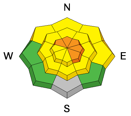
description
Very strong winds yesterday drifted the heavy new snow into avalanche starting zones at upper elevations, and you are likely to trigger wind slab avalanches up to around 2 feet deep on some steep drifted slopes. Expect to find new drifts and wind slabs well off major ridge lines and perhaps in rather unexpected places.
|
| type | aspect/elevation | characteristics |
|---|

|
|
LIKELIHOOD
 LIKELY
UNLIKELY
SIZE
LARGE
SMALL
TREND
INCREASING DANGER
SAME
DECREASING DANGER
|
|
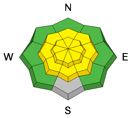
description
In some areas, the heavy new snow may not have bonded very well with a widespread thick rime-crust that was on the snow surface, mainly at upper elevations. Soft slab avalanches and long running loose sluffs are possible on slopes with significant accumulations of new snow..
|
| type | aspect/elevation | characteristics |
|---|

|
|
LIKELIHOOD
LIKELY
UNLIKELY
SIZE
LARGE
SMALL
TREND
 INCREASING DANGER
SAME
DECREASING DANGER
|
|
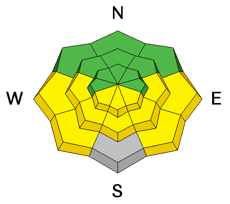
description
Much cooler temperatures are helping to solidify and stabilize the saturated low elevation snow, but loose wet avalanches involving yesterday's fresh snow will become more likely in some areas as daytime and solar warming heats up and dampens the snow surface... The (mostly manageable) wet avalanche problem will probably only effect sunny slopes, but significant fresh snow could be entrained in sluffs on longer slopes. Some natural activity is possible on sunny slopes likely to be initiated by snow falling of trees or rocks. |
 |
weather TRANQUIL WEATHER IS LARGELY EXPECTED THROUGH THE MIDDLE OF NEXT WEEK...THOUGH WEAK SYSTEMS MAY CLIP FAR NORTHERN UTAH FRIDAY NIGHT INTO SATURDAY AND AGAIN SUNDAY NIGHT INTO MONDAY. |
| general announcements Please submit snow and avalanche observations from your ventures in the backcountry HERE. You can call us at 801-524-5304 or email HERE, or include #utavy in your Instagram or Tweet us @UAClogan. To report avalanche activity in the Logan Area or to contact the local avalanche forecaster call me, Toby, at 435-757-7578. We'll update this advisory throughout the season on Monday, Wednesday, Friday, and Saturday mornings by about 7:30 This advisory is produced by the U.S.D.A. Forest Service, which is solely responsible for its content. It describes only general avalanche conditions and local variations always exist. Backcountry Responsibility Objective from Trent Meisenheimer on Vimeo. |


