| Please join us at the 23rd annual Black Diamond Fall Fundraiser Party Thursday Sept 15. Tickets are on sale now here, at the Black Diamond store & at REI. Special bonus raffle for online ticket purchasers! |
| Please join us at the 23rd annual Black Diamond Fall Fundraiser Party Thursday Sept 15. Tickets are on sale now here, at the Black Diamond store & at REI. Special bonus raffle for online ticket purchasers! |
| Advisory: Logan Area Mountains | Issued by Toby Weed for Wednesday - February 17, 2016 - 7:14am |
|---|

|
bottom line CONSIDERABLE (level 3): People should continue to stay off of and out from under steep slopes with soft saturated snow. Dangerous avalanche conditions exist and will develop in the backcountry today on rain saturated slopes at lower and mid elevations in the heat of the day. You could trigger wind slab avalanches on drifted upper elevation slopes Human-triggered avalanches are likely and natural avalanches are possible on slopes steeper than about 30 degrees. Careful snowpack evaluation, cautious route finding, and conservative decision-making will be essential again today.
|
 |
special announcement We are offering an Avalanche Awareness for Snowmobilers Course on February 25 & 27. For more information and to register go..... HERE
|
 |
current conditions The 8400' Tony Grove Snotel reports 32 degrees this morning and there's 73 inches of total snow containing 103% of average water content for the date. I'm reading 34 degrees at the 9700' CSI Logan Peak weather station, and south winds averaging 25 mph this morning. The snow at mid and lower elevations yesterday was very soft, inverted, and saturated by rain, and lacking a good overnight freeze again and with very warm temperatures forecast for today, dangerous wet avalanche conditions will again exist at lower elevations.
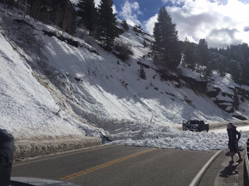
A couple natural loose wet avalanches hit Hwy 89 in the Dugway on Monday. The second one crossed both lanes at around 2:30 in the afternoon. (A.Ward 2-15-16)
|
 |
recent activity
|
| type | aspect/elevation | characteristics |
|---|

|
|
LIKELIHOOD
 LIKELY
UNLIKELY
SIZE
 LARGE
SMALL
TREND
 INCREASING DANGER
SAME
DECREASING DANGER
|
|
description
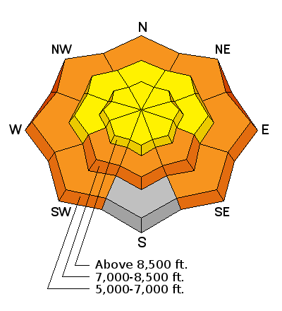
Expect a rising danger of wet avalanches at low elevations as temperatures soar in the Mountains today. Rain saturated the low elevation snow, significant natural wet avalanches occurred Monday with periods of solar warming on steep low and mid elevation slopes. Significant loose wet avalanches involving saturated soft snow are again likely with midday heating today on steep slopes below the rain/snow line... Dangerous wet slab avalanches remain possible in some low elevation areas with saturated snow and poor snow structure. |
| type | aspect/elevation | characteristics |
|---|

|
|
LIKELIHOOD
 LIKELY
UNLIKELY
SIZE
LARGE
SMALL
TREND
 INCREASING DANGER
SAME
DECREASING DANGER
|
|
description
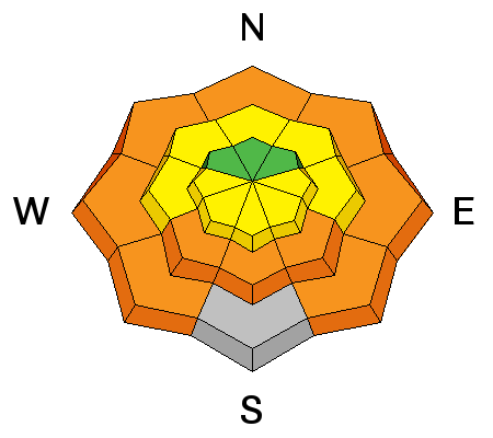
Triggered wind slab avalanches up to around 2 feet deep are again possible at upper elevations today. A thick rime or rain crust formed up to upper elevations in many areas and may be welding most of the wind slabs in place, but this lack of sensitivity may also allow people to get well out on the wind slabs before they fail.
|
 |
weather We'll see increasing clouds and south wind ahead of the next storm system. and high temperatures in the mountains pushing 50 degrees! Expect increasing south winds, averaging in the mid twenties and gusting to around 40 mph. Snow is likely tonight and Thursday, with 4 to 9 inches of accumulation forecast. Expect very windy conditions in the mountains, periods of heavy snow, thunder and lightning possible, and dropping temperatures with the storm tomorrow.
|
| general announcements Please submit snow and avalanche observations from your ventures in the backcountry HERE. You can call us at 801-524-5304 or email HERE, or include #utavy in your Instagram or Tweet us @UAClogan. To report avalanche activity in the Logan Area or to contact the local avalanche forecaster call me, Toby, at 435-757-7578. We'll update this advisory throughout the season on Monday, Wednesday, Friday, and Saturday mornings by about 7:30 This advisory is produced by the U.S.D.A. Forest Service, which is solely responsible for its content. It describes only general avalanche conditions and local variations always exist. |