| Please join us at the 23rd annual Black Diamond Fall Fundraiser Party Thursday Sept 15. Tickets are on sale now here, at the Black Diamond store & at REI. Special bonus raffle for online ticket purchasers! |
| Please join us at the 23rd annual Black Diamond Fall Fundraiser Party Thursday Sept 15. Tickets are on sale now here, at the Black Diamond store & at REI. Special bonus raffle for online ticket purchasers! |
| Advisory: Logan Area Mountains | Issued by Toby Weed for Monday - February 15, 2016 - 3:53pm |
|---|

|
bottom line UPDATE: 2-15-16, 1600: Large natural wet avalanches are occurring today in Logan Canyon and at lower and mid elevations across the zone, prompting an update to a HIGH danger at lower elevations.. CONSIDERABLE (level 3): Dangerous avalanche conditions exist in the backcountry on rain saturated slopes at lower elevations, in drifted upper elevation terrain, and on steep slopes with significant accumulations of heavy new snow. Human-triggered avalanches are likely and natural avalanches possible on many slopes steeper than about 30 degrees. People should avoid and stay out from under steep slopes with saturated snow, as well as drifted slopes and slopes with significant fresh accumulations at upper elevations. Careful snowpack evaluation, cautious route finding, and conservative decision-making will be essential today.
|
 |
current conditions A good shot of heavy new snow and significant drifting from strong west winds at upper elevations, and rain-on-snow down lower have created dangerous avalanche conditions in the backcountry. It's quite windy and still pretty warm in the mountains this morning. The 8400' Tony Grove Snotel reports slowly rising temperatures overnight, and it's 32 degrees this morning. The depth sensor reports an 8 inch increase in total snow containing 1.6 inches of water in the last 24 hours. There's 74 inches of total snow at the site , containing 105% of average water content for the date. I'm reading 26 degrees at the 9700' CSI Logan Peak weather station, and the wind sensor is rimed. Ogden Peak shows sustained westerly winds overnight averaging in the upper 30s and gusting to around 50 mph early this morning.
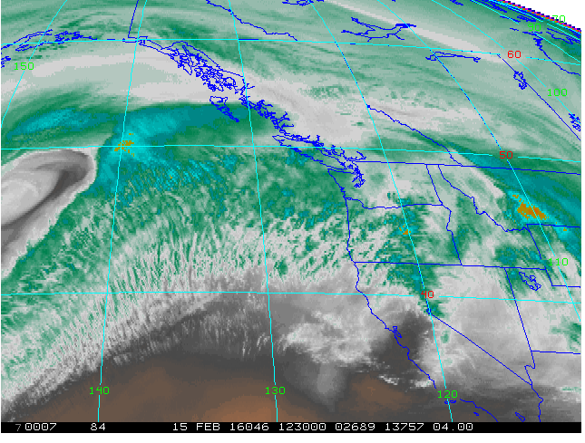
The 4k water vapor satellite image shows ample moisture approaching Southeast Idaho and the Bear River Range this morning, and we expect strong westerlies in the mountains. The National Weather Service in Pocatello has issued a Winter Weather Advisory for the mountains in Bear Lake and Franklin Counties.
|
 |
recent activity
|
| type | aspect/elevation | characteristics |
|---|

|
|
LIKELIHOOD
 LIKELY
UNLIKELY
SIZE
 LARGE
SMALL
TREND
 INCREASING DANGER
SAME
DECREASING DANGER
|
|
description
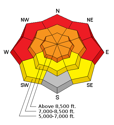
Large natural wet avalanches are occurring today in Logan Canyon and at lower and mid elevations across the zone, prompting an update to HIGH danger. Rain saturated the low elevation snow, natural sluffing occurred yesterday afternoon and probably continued overnight on steep low elevation slopes. Significant loose wet avalanches involving saturated soft snow are likely today on steep slopes below the elusive rain/snow line... Dangerous wet slab avalanches are possible in some low elevation areas with poor snow structure.
|
| type | aspect/elevation | characteristics |
|---|

|
|
LIKELIHOOD
LIKELY
UNLIKELY
SIZE
LARGE
SMALL
TREND
INCREASING DANGER
SAME
DECREASING DANGER
|
|
description
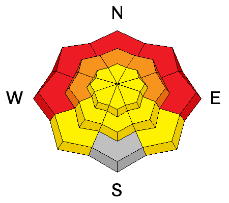
Triggered wind slab avalanches up to around 2 feet deep are likely at upper elevations today, and natural activity is possible, as significant drifting from strong and sustained west winds continues. Fresh and sizable wind slabs were deposited overnight on the lee sides of ridges, cross-loaded along sub-ridges, and they formed in and around terrain features like rock outcroppings, gullies, scoops, trees, and saddles. Beware the growing ridge-top cornices, which could break further back than you expect and today are likely to trigger wind slab avalanches on drifted slopes below. Avoid obvious and historic avalanche paths and stay off of and out from under steep drifted slopes. ***Persistent and/or deep slab avalanches are possible on drifted slopes in outlying areas with shallow weak snow.
|
| type | aspect/elevation | characteristics |
|---|

|
|
LIKELIHOOD
LIKELY
UNLIKELY
SIZE
LARGE
SMALL
TREND
 INCREASING DANGER
SAME
DECREASING DANGER
|
|
description
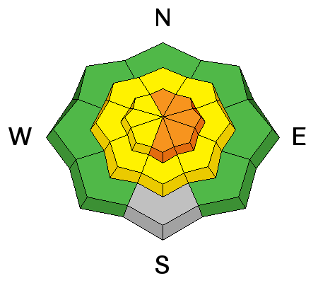
Soft storm slabs and long running sluffs involving the storm snow are likely, especially on steep upper elevation slopes with significant accumulations of heavy new snow. Storm slabs may fail on weak small grained sugary snow that was on the surface last week called near surface facets, or on feathery frost crystals called surface hoar, which formed during last week's high pressure and may have been buried intact on some slopes.
|
 |
weather The National Weather Service in Pocatello has issued a Winter Weather Advisory for the mountains in Bear Lake and Franklin Counties.... Weather Forecast: Tony Grove Lake (41.897,-111.6535), Elevation: 8800'
|
| general announcements Please submit snow and avalanche observations from your ventures in the backcountry HERE. You can call us at 801-524-5304 or email HERE, or include #utavy in your Instagram or Tweet us @UAClogan. To report avalanche activity in the Logan Area or to contact the local avalanche forecaster call me, Toby, at 435-757-7578. We'll update this advisory throughout the season on Monday, Wednesday, Friday, and Saturday mornings by about 7:30 This advisory is produced by the U.S.D.A. Forest Service, which is solely responsible for its content. It describes only general avalanche conditions and local variations always exist. |