| Please join us at the 23rd annual Black Diamond Fall Fundraiser Party Thursday Sept 15. Tickets are on sale now here, at the Black Diamond store & at REI. Special bonus raffle for online ticket purchasers! |
| Please join us at the 23rd annual Black Diamond Fall Fundraiser Party Thursday Sept 15. Tickets are on sale now here, at the Black Diamond store & at REI. Special bonus raffle for online ticket purchasers! |
| Advisory: Logan Area Mountains | Issued by Toby Weed for Saturday - February 13, 2016 - 6:09am |
|---|

|
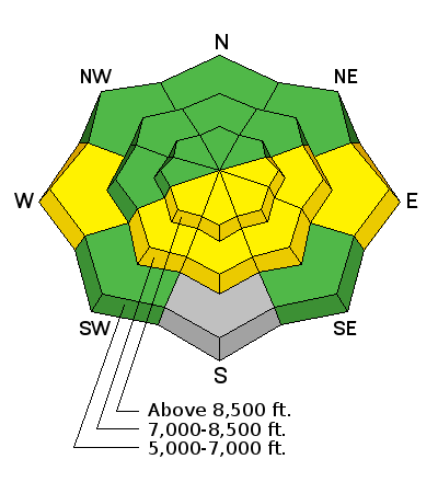
bottom line MODERATE (level 2): Heightened wet avalanche conditions will again develop on sunny slopes in the midday heat. Otherwise mostly stable snow conditions exist, and there's a LOW danger on slopes facing the north half of the compass. Use normal caution, evaluate the snow and terrain carefully, and avoid midday travel on or under steep sunny slopes.
|
 |
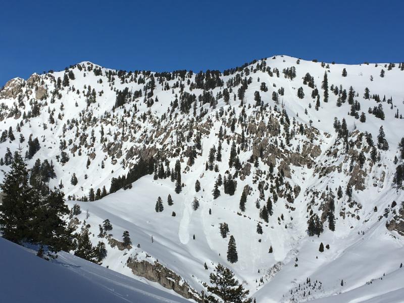
current conditions It's breezy on the ridge tops, and it's quite warm in the mountains again this morning with a poor overnight freeze especially at mid elevations. I'm reading 30 degrees at the 9700' CSI Logan Peak weather station, and southwest wind increased overnight, currently averaging close to 30 mph. The 8400' Tony Grove Snotel reports above freezing overnight temperatures, as has been the case for the last several nights, and it's a toasty 37 degrees this morning. There's 67 inches of total snow at the site , containing 101% of average water content for the date. We are finding good stability in north facing terrain with deep (or average) snowcover, and even shallower areas with poor snow structure are showing signs of dormancy and increasing stability. |
 |
recent activity Natural loose wet avalanches were flowing off south facing slopes in the midday heat like hot candle wax this week. The midday activity affected most slopes facing the south half of the compass in the zone, with some avalanches running pretty far. Natural wet avalanches were triggered this week in the heat of the day by snow rolling off rocks, tree bombs, and even moose.
Fresh natural loose wet avalanches on the north side of Cherry Creek Canyon in the Mt Naomi Wilderness. (2-10-16) An observer on the west shore of Bear Lake, in Fish Haven Idaho, reported a fairly large fresh hard slab avalanche last weekend on an east facing slope at around 7100' in elevation. View the Avalanche Report
***To view our updated list of backcountry observations and avalanche activity from around Utah, go to our observations page
|
| type | aspect/elevation | characteristics |
|---|

|
|
LIKELIHOOD
 LIKELY
UNLIKELY
SIZE
 LARGE
SMALL
TREND
 INCREASING DANGER
SAME
DECREASING DANGER
|
|
description
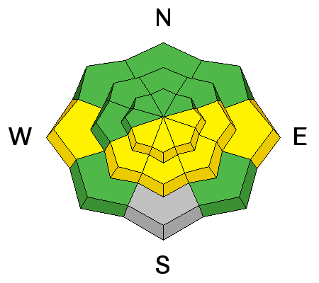
A nice breeze from the southwest and increasing clouds should help matters today. We should see less frequent natural sluffing in sunny terrain, but triggered avalanches remain possible (and perhaps will be likely again) in the heat of the day on any steep slope with warmth-softened saturated snow. Avoid midday travel on or below steep sunny slopes.
|
| type | aspect/elevation | characteristics |
|---|

|
|
LIKELIHOOD
LIKELY
UNLIKELY
SIZE
LARGE
SMALL
TREND
 INCREASING DANGER
SAME
DECREASING DANGER
|
|
description
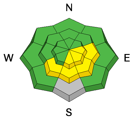
Wet slab avalanches are possible in sunny areas with poor snow structure. Here's why;
|
| type | aspect/elevation | characteristics |
|---|

|

|
LIKELIHOOD
 LIKELY
UNLIKELY
SIZE
 LARGE
SMALL
TREND
INCREASING DANGER
SAME
DECREASING DANGER
|
|
description
Persistent slab avalanches are unlikely but remain possible in outlying areas with shallow weak snow. You will have to dig down into the snow and look for layers consisting of weak sugary faceted snow and a poor snow structure. Avoid areas where a slab of stronger snow sits atop weak faceted snow. Pockets of possible instability exist in windswept rocky upper and mid elevation elevation terrain, slopes that avalanched earlier in the winter, and in some areas at lower elevations where the thin snowpack is very weak.. |
 |
weather A couple weak weather systems will cross over the region this weekend, hopefully bringing some relief from the smog and a chance of snow showers. It'll be partly sunny today with increasing clouds and west wind, and a high temperature at 8500' of around 43 degrees. Snow showers are possible. Expect mostly cloudy conditions in the mountains tonight with a low around 24 degrees, west wind and a 30% chance of snow, but little accumulation. Snow is likely tomorrow, with 1 or 2 inches of accumulation, increasing west winds, and a high temperature around 36 degrees. Unsettled weather, windy conditions, and periods of light snow will continue through Monday, with high pressure conditions rebounding for the early part of next week. |
| general announcements Please submit snow and avalanche observations from your ventures in the backcountry HERE. You can call us at 801-524-5304 or email HERE, or include #utavy in your Instagram or Tweet us @UAClogan. To report avalanche activity in the Logan Area or to contact the local avalanche forecaster call me, Toby, at 435-757-7578. We'll update this advisory throughout the season on Monday, Wednesday, Friday, and Saturday mornings by about 7:30 This advisory is produced by the U.S.D.A. Forest Service, which is solely responsible for its content. It describes only general avalanche conditions and local variations always exist. |