| Please join us at the 23rd annual Black Diamond Fall Fundraiser Party Thursday Sept 15. Tickets are on sale now here, at the Black Diamond store & at REI. Special bonus raffle for online ticket purchasers! |
| Please join us at the 23rd annual Black Diamond Fall Fundraiser Party Thursday Sept 15. Tickets are on sale now here, at the Black Diamond store & at REI. Special bonus raffle for online ticket purchasers! |
| Advisory: Logan Area Mountains | Issued by Toby Weed for Wednesday - February 10, 2016 - 6:41am |
|---|


|
bottom line MODERATE (level 2): Heightened avalanche conditions exist in the backcountry, and you might trigger avalanches on many different slopes. Evaluate the snow and terrain carefully, make conservative decisions, and avoid midday travel on or under steep sunny slopes.
|
 |
current conditions It's way too warm in the mountains this morning , with 35 degrees at 5:00 at the 8400' Tony Grove Snotel. There's 71 inches of total snow, containing 106% of average water content for the date. The 9700' CSI Logan Peak weather station reports a balmy 36 degrees and an increase in southwest wind overnight, currently averaging 26 mph and gusting into the thirties. Sun and warmth in the daytime and radiation heat-loss durring the clear nights are causing the snow surface to cycle between saturated midday to refrozen melt/freeze crusts of widely varying thickness at night and in the mornings. You might find some hidden stashes on the more north facing slopes, with nice smooth and fast settled or recrystalized powder.
|
 |
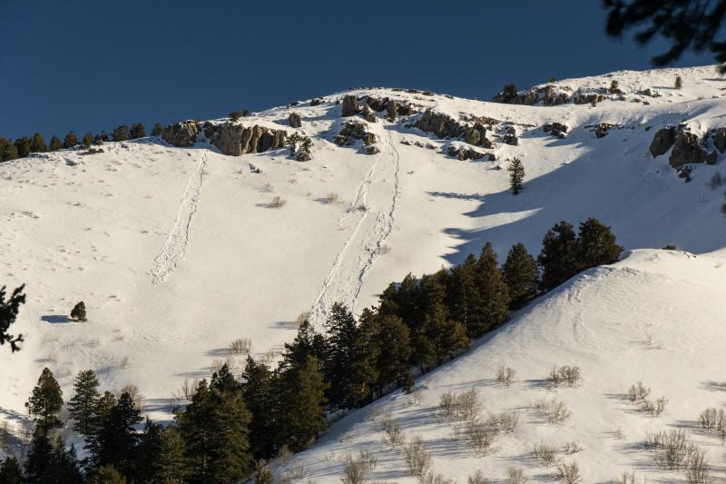
recent activity Natural loose wet avalanches are flowing off south facing slopes these days like hot wax off an old candle. The activity appears to be occurring midday, working it's way around the south half of the compass with the sun. Wet avalanches were triggered recently in the heat of the day by snow rolling off rocks, tree bombs, and even moose.
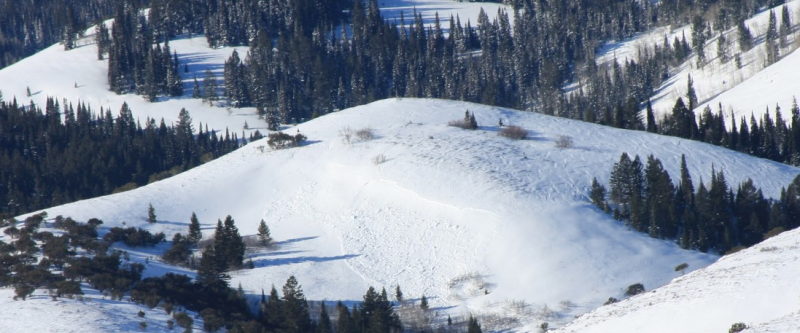
A fresh natural loose wet avalanche on the north side of Logan Dry Canyon. (Gottlieb, 2-9-16) An observer on the west shore of Bear Lake, in Fish Haven Idaho, reports a fairly large fresh hard slab avalanche viewed on Sunday on a east facing slope at around 7100' in elevation. It looks like westerly winds over the weekend were enough to overload a slope plagued by weak sugary or faceted snow near the ground. view the Avalanche Report
A wind slab formed by drifting from sustained westerly winds released on a fairly low elevation slope over the weekend near Fish Haven. The avalanche appears to have stepped down into weak faceted snow near the ground, which is widespread in the area. (Tavis, 2-7-16) ***To view our updated list of backcountry observations and avalanche activity from around Utah, go to our observations page
|
| type | aspect/elevation | characteristics |
|---|

|

|
LIKELIHOOD
 LIKELY
UNLIKELY
SIZE
 LARGE
SMALL
TREND
 INCREASING DANGER
SAME
DECREASING DANGER
|
|
description
Natural loose wet avalanches will become likely again today as the surface snow on sunny slopes warms and becomes saturated. Crusts formed overnight due to radiation heat-loss (not freezing air temperatures) will soften during the heat of the day, and avalanches might be initiated by snow falling off rocks or trees onto steep slopes below. Roller balls or natural sluffs nearby indicate the potential for and an increasing danger of wet avalanches. Continued warm nights and possible cloud cover (preventing radiation heat loss) could cause an increasing possibility of dangerous wet slab avalanches in areas with existing weak layers or poor snow structure Avoid midday travel on or below steep sunny slopes.
|
| type | aspect/elevation | characteristics |
|---|

|
|
LIKELIHOOD
 LIKELY
UNLIKELY
SIZE
 LARGE
SMALL
TREND
 INCREASING DANGER
SAME
DECREASING DANGER
|
|
description
A lingering possibility of triggering a dangerous persistent slab avalanche exists in outlying terrain and on some isolated slopes with thin and weak snow cover. The slopes we are concerned with have poor snow structure. Weak sugary or faceted snow near the ground overloaded by a slab layer of harder snow creates a potentially unstable situation. Beware areas that avalanched earlier in the winter, since weak snow remained in the bed surfaces and the areas remained shallow. Weak snow structure exists mainly in areas where the total snow is 3 feet deep or less. Persistent slab avalanches are possible in rocky upper elevation terrain, and the thin snowpack is also very weak in many areas at lower and mid elevations.
I found these very weak and well developed faceted snow grains near the ground on a mid-elevation northwest facing slope in Logan Canyon on Sunday (2-7-16). In some shallow areas the snow was completely rotten, faceted and loose from surface to ground.
|
| type | aspect/elevation | characteristics |
|---|

|

|
LIKELIHOOD
 LIKELY
UNLIKELY
SIZE
LARGE
SMALL
TREND
INCREASING DANGER
SAME
DECREASING DANGER
|
|
description
Watch for and avoid recently formed and older wind drifts near ridge tops and in and around terrain features like gullies, sub-ridges, scoops, and rock outcroppings. Older stiff wind slabs failing on preexisting weak surface snow are still possible in some areas today. Hard wind slabs have the nasty tendency to sometimes allow you to get out on them before releasing.
|
 |
weather The strong high pressure system overhead will dominate the weather pattern through the week, with very warm temperatures in the mountains and deteriorating air quality and fog in the valleys. A couple weak weather systems will cross over the region this weekend, bringing some cloud cover and a chance of snow showers... |
| general announcements Please submit snow and avalanche observations from your ventures in the backcountry HERE. You can call us at 801-524-5304 or email HERE, or include #utavy in your Instagram or Tweet us @UAClogan. To report avalanche activity in the Logan Area or to contact the local avalanche forecaster call me, Toby, at 435-757-7578. I'll update this advisory throughout the season on Monday, Wednesday, Friday, and Saturday mornings by about 7:30 This advisory is produced by the U.S.D.A. Forest Service, which is solely responsible for its content. It describes only general avalanche conditions and local variations always exist. |


_0.JPG)