| Please join us at the 23rd annual Black Diamond Fall Fundraiser Party Thursday Sept 15. Tickets are on sale now here, at the Black Diamond store & at REI. Special bonus raffle for online ticket purchasers! |
| Please join us at the 23rd annual Black Diamond Fall Fundraiser Party Thursday Sept 15. Tickets are on sale now here, at the Black Diamond store & at REI. Special bonus raffle for online ticket purchasers! |
| Advisory: Logan Area Mountains | Issued by Toby Weed for Sunday - January 31, 2016 - 7:01am |
|---|

|
bottom line HIGH (level 4): Dangerous avalanche conditions exist in the backcountry. Human-triggered avalanches are likely on slopes with significant fresh accumulations steeper than about 30 degrees, especially in drifted upper elevation terrain. We recommend that you continue to stay off of and out from under steep slopes and avoid obvious and historic avalanche paths.
|
 |
current conditions The temperature is 11 degrees at the 8400' Tony Grove Snotel and there are several more inches of light new snow from yesterday capping heavier snow from Friday night. The snow pillow reports a gain of 2.8 inches of water in the last 72 hours, and I'm reading 79 inches of total snow, containing 109% of average water content for the date. The 9700' CSI Logan Peak weather station reports 7 degrees and the wind sensor appears rimed. The UDOT Hwy 89 summit weather station reports 6 degrees and light to moderate wind from the northwest overnight, veering from the east with speeds in the single digits this morning. Dangerous conditions exist in the backcountry, and people should avoid travel in avalanche terrain today. Human triggered avalanches are likely. We recommend you stay off of and out from under obvious or historic avalanche paths and slopes steeper than about 30 degrees.
|
 |
recent activity
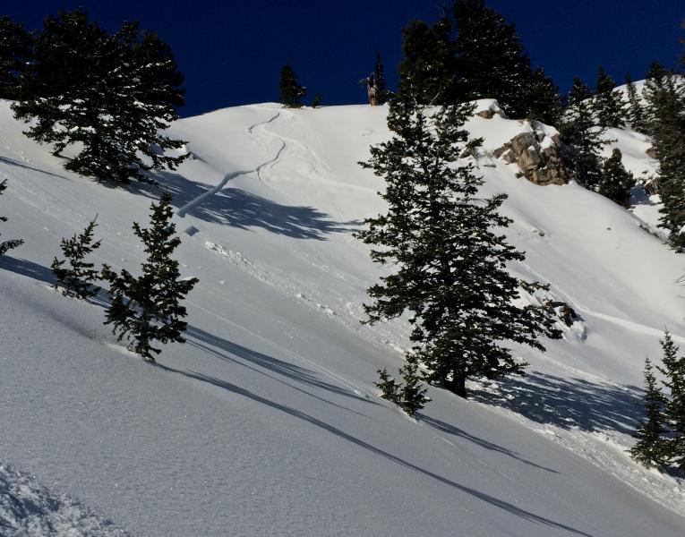
A skier triggered and then escaped this shallow wind slab avalanche in Wildcat Bowl in the Wood Camp Area on Wednesday (1-27-16). Several other similar (apparently manageable) avalanches were triggered by people locally last week. Ski Areas in the Ogden Area Mountains report active avalanche conditions yesterday, with numerous avalanches (some fairly large) intentionally triggered by avalanche control teams. A hiker on snow-shoes triggered and may have been caught in a loose (wet?) avalanche at the mouth of Logan Dry Canyon yesterday. We received few other reports locally from the backcountry, and with poor visibility of avalanche terrain, we're faced with a high degree of uncertainty regarding yesterday's probable natural activity. There were several (apparently manageable) human triggered avalanches last week. These on north through east facing upper and mid elevation slopes were around a foot deep and up to about 50' wide. A video posted on Facebook from a large sled triggered avalanche (1-19-16) in Christmas Tree Bowl is .....HERE ***To view our updated list of backcountry observations and avalanche activity from around Utah, go to our observations page
|
| type | aspect/elevation | characteristics |
|---|

|
|
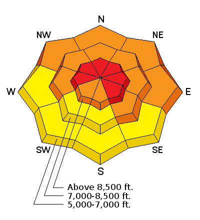
LIKELIHOOD
 LIKELY
UNLIKELY
SIZE
 LARGE
SMALL
TREND
 INCREASING DANGER
SAME
DECREASING DANGER
|
|
description
Storm slab and/or wind slab avalanches including the new snow and failing within or on preexisting weak surface snow are likely in steep terrain today.
|
| type | aspect/elevation | characteristics |
|---|

|
|
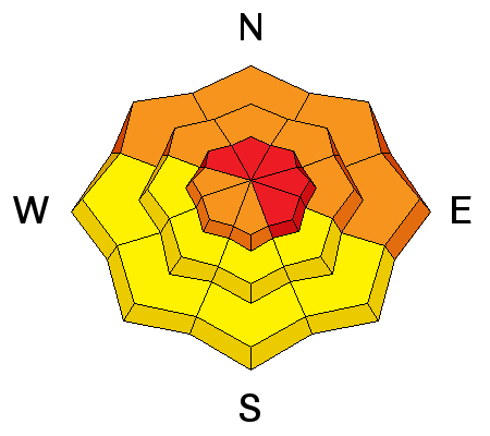
LIKELIHOOD
 LIKELY
UNLIKELY
SIZE
 LARGE
SMALL
TREND
 INCREASING DANGER
SAME
DECREASING DANGER
|
|
description
Heavy new snow, rain-on-snow at lower elevations, and strong winds overloaded a complex snowpack, with existing buried persistent weak layers in some areas and still weak basal layer depth hoar in others.
***Pay close attention to signs of unstable snow like recent avalanches, whumpfing, and shooting cracks, and be willing to reevaluate your plans. In these conditions you could trigger avalanches remotely, from a distance or worse, from below!
|
 |
weather A WINTER STORM WILL AFFECT MOSTLY SOUTHERN AND CENTRAL UTAH THROUGH MONDAY NIGHT...BRINGING SIGNIFICANT SNOW ACCUMULATIONS AND GUSTY WINDS. COLD NORTHERLY FLOW WILL FOLLOW ACROSS THE REGION FOR THE MIDDLE PORTION OF NEXT WEEK.
|
| general announcements Please submit snow and avalanche observations from your ventures in the backcountry HERE. You can call us at 801-524-5304 or email HERE, or include #utavy in your Instagram or Tweet us @UAClogan. To report avalanche activity in the Logan Area or to contact the local avalanche forecaster call me, Toby, at 435-757-7578. I'll update this advisory throughout the season on Monday, Wednesday, Friday, and Saturday mornings by about 7:30 This advisory is produced by the U.S.D.A. Forest Service, which is solely responsible for its content. It describes only general avalanche conditions and local variations always exist. |