| Please join us at the 23rd annual Black Diamond Fall Fundraiser Party Thursday Sept 15. Tickets are on sale now here, at the Black Diamond store & at REI. Special bonus raffle for online ticket purchasers! |
| Please join us at the 23rd annual Black Diamond Fall Fundraiser Party Thursday Sept 15. Tickets are on sale now here, at the Black Diamond store & at REI. Special bonus raffle for online ticket purchasers! |
| Advisory: Logan Area Mountains | Issued by Toby Weed for Wednesday - January 27, 2016 - 7:17am |
|---|


|
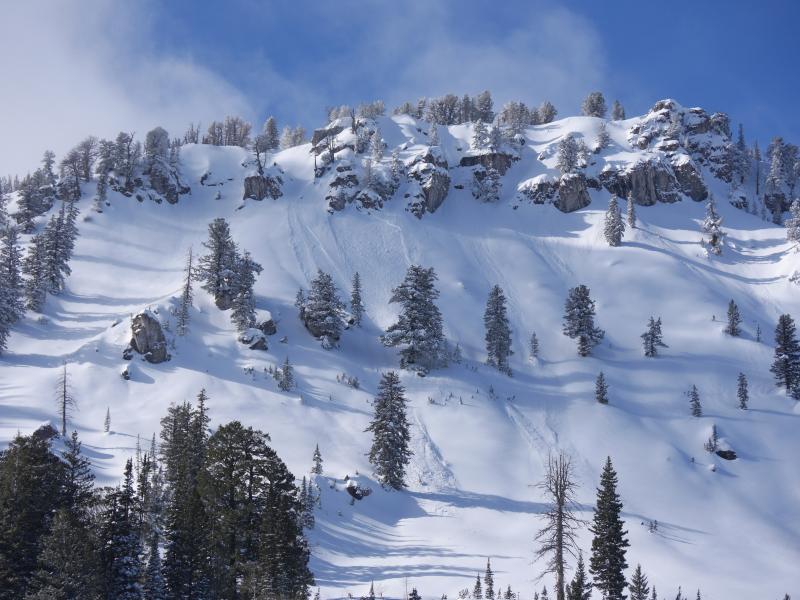
bottom line MODERATE (Level 2): The snow continues to slowly stabilize in the backcountry, but heightened avalanche conditions remain in many areas. Evaluate the snow and terrain carefully, especially on recently drifted slopes with poor snow structure. You might find more dangerous avalanche conditions and pockets of CONSIDERABLE (level 3) danger in some outlying areas. Large and dangerous triggered avalanches are possible on some upper and mid elevation slopes steeper than about 30 degrees. Avalanches could still be triggered remotely, from a distance, or even below!
|
 |
current conditions The temperature is 24 degrees this morning at the 8400' Tony Grove Snotel. There's 68 inches of total snow, containing 101% of average water content for the date. The 9700' CSI Logan Peak weather station reports 23 degrees and north-northwest winds overnight, currently averaging about 15 mph. Some low clouds and a cool northwest breeze kept the powder nice, even on sunny slopes yesterday. I found nice smooth and pretty fast powder riding conditions yesterday, and no need to push into steeper terrain, with lower angled sunny slopes still in great shape.
I noticed a couple fresh wind slab avalanches in Steep Hollow yesterday. This one on an east facing slope at around 9500' in elevation wasn't all that big, involving only new snow, but the debris from the avalanche piled up deeply in a shallow mid-slope gully. (1-26-2106)
|
 |
recent activity
***To view our updated list of backcountry observations and avalanche activity from around Utah, go to our observations page |
| type | aspect/elevation | characteristics |
|---|

|
|
LIKELIHOOD
 LIKELY
UNLIKELY
SIZE
 LARGE
SMALL
TREND
 INCREASING DANGER
SAME
DECREASING DANGER
|
|
description
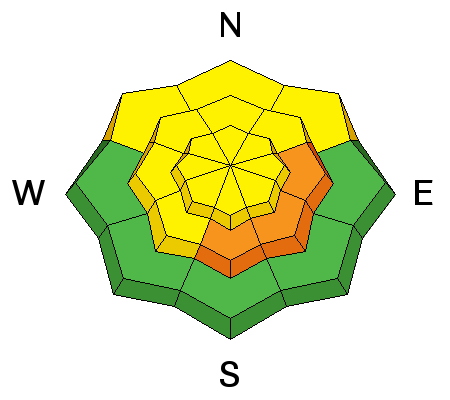
Triggered persistent slab avalanches remain possible in some areas today. Last week a slab layer accumulated on weak surface snow that is now a buried persistent weak layer which is becoming more stable but could stay reactive for several more days. My snowpit tests are still showing moderate failures and slab propagation in some areas... Mainly where the slab from last week's snow is about 2' deep or less, including on sunny or generally south facing slopes.
|
| type | aspect/elevation | characteristics |
|---|

|
|
LIKELIHOOD
LIKELY
UNLIKELY
SIZE
LARGE
SMALL
TREND
INCREASING DANGER
SAME
DECREASING DANGER
|
|
description
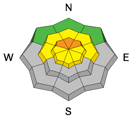
In some areas, the faceted snow in the basal layers of the snowpack was reactivated by the recently added weight of new snow. Dangerous and destructive deep slab avalanches involving old snow and failing on sugary faceted snow or depth hoar are still possible, especially in areas with shallow snow cover and poor snow structure. ***Pay close attention to signs of unstable snow like recent avalanches, whumpfing, and shooting cracks, and be willing to reevaluate your plans. In these conditions you could trigger avalanches remotely, from a distance or worse, from below!
|
| type | aspect/elevation | characteristics |
|---|

|
|
LIKELIHOOD
LIKELY
UNLIKELY
SIZE
 LARGE
SMALL
TREND
 INCREASING DANGER
SAME
DECREASING DANGER
|
|
description
Watch for and avoid recent drifts and/or wind slabs near ridge tops and in and around terrain features like gullies, sub-ridges, scoops, and rock outcroppings. |
 |
weather It'll be mostly sunny today, with a 8500' high near 32 degrees and moderate west-northwest wind. Expect partly cloudy conditions tonight, with a low around 19 degrees. Sunny again tomorrow, with a high temperature around 34 and increasing west wind especially Thursday night. Snow is likely on Friday, with further increasing west winds and 2 to 4 inches of accumulation possible. The storm will continue Friday night and Saturday, with breezy conditions, and 7 to 13 inches of accumulation possible. Stormy and potentially very moist and snowy conditions will continue through the first half of next week, with significant accumulations likely.
|
| general announcements The CROWBAR backcountry ski race will be Saturday January 30. More info at http://CrowbarSkiRace.org. Please submit snow and avalanche observations from your ventures in the backcountry HERE. You can call us at 801-524-5304 or email HERE, or include #utavy in your Instagram or Tweet us @UAClogan. To report avalanche activity in the Logan Area or to contact the local avalanche forecaster call me, Toby, at 435-757-7578. I'll update this advisory throughout the season on Monday, Wednesday, Friday, and Saturday mornings by about 7:30 This advisory is produced by the U.S.D.A. Forest Service, which is solely responsible for its content. It describes only general avalanche conditions and local variations always exist. |