| Please join us at the 23rd annual Black Diamond Fall Fundraiser Party Thursday Sept 15. Tickets are on sale now here, at the Black Diamond store & at REI. Special bonus raffle for online ticket purchasers! |
| Please join us at the 23rd annual Black Diamond Fall Fundraiser Party Thursday Sept 15. Tickets are on sale now here, at the Black Diamond store & at REI. Special bonus raffle for online ticket purchasers! |
| Advisory: Logan Area Mountains | Issued by Toby Weed for Monday - January 25, 2016 - 6:56am |
|---|

|
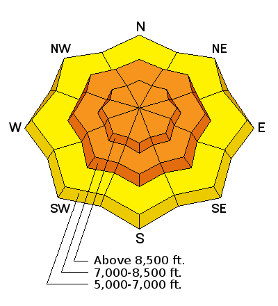
bottom line CONSIDERABLE (Level 3): The snow continues to slowly stabilize in the backcountry, but dangerous avalanche conditions still exist in some areas. Careful snowpack evaluation, cautious routefinding, and conservative decision-making will be essential again today. Large and dangerous triggered avalanches are possible on upper and mid elevation slopes steeper than about 30 degrees. Avalanches could be triggered remotely, from a distance, or even below!
|
 |
current conditions The temperature is 17 degrees this morning at the 8400' Tony Grove Snotel. The station reported 9 inches of new snow yesterday, and .7" of water in the last 24 hours. There's 72 inches of total snow, containing 104% of average water content for the date. The 9700' CSI Logan Peak weather station reports 9 degrees and fairly light northwest winds overnight, currently averaging about 3 mph.
|
 |
recent activity
***To view our updated list of backcountry observations and avalanche activity from around Utah, go to our observations page
|
| type | aspect/elevation | characteristics |
|---|

|
|
LIKELIHOOD
 LIKELY
UNLIKELY
SIZE
 LARGE
SMALL
TREND
 INCREASING DANGER
SAME
DECREASING DANGER
|
|
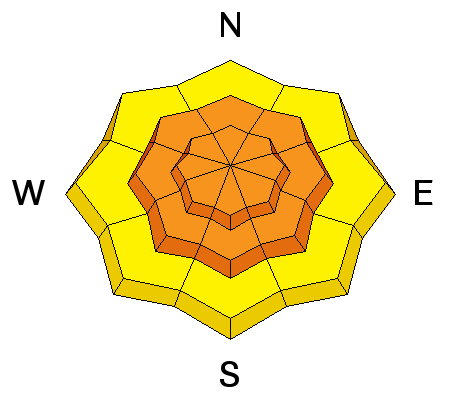
description
Triggered persistent and/or deep slab avalanches remain likely in some areas today. Last week a slab layer accumulated on weak surface snow that is now a buried persistent weak layer which is becoming more stable but could stay reactive for several more days. In some areas, the faceted snow in the basal layers of the snowpack were reactivated by the recently added weight of new snow. Dangerous and destructive deep slab avalanches involving old snow and failing on sugary faceted snow or depth hoar are possible, especially in areas with shallow snow cover and poor snow structure. ***Pay close attention to signs of unstable snow like recent avalanches, whumpfing, and shooting cracks, and be willing to reevaluate your plans. In these conditions you could trigger avalanches remotely, from a distance or worse, from below!
|
| type | aspect/elevation | characteristics |
|---|

|
|
LIKELIHOOD
LIKELY
UNLIKELY
SIZE
 LARGE
SMALL
TREND
 INCREASING DANGER
SAME
DECREASING DANGER
|
|
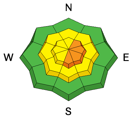
description
Watch for and avoid recent drifts and/or wind slabs near ridge tops and in and around terrain features like gullies, sub-ridges, scoops, and rock outcroppings.
|
 |
weather Scattered snow showers are possible this morning, then it'll be partly sunny this afternoon, with 8500' high temperatures around 23 degrees and moderate northwest wind. There's a chance for a few snow showers tonight, with low temperatures around 10 degrees and a continuing northwest breeze. It'll be mostly sunny tomorrow with a high near 27 degrees and moderate west-northwest wind. Looks like a high pressure system will build over the region, with the next chance for snow and more wintry weather coming on around Friday.
|
| general announcements The CROWBAR backcountry ski race will be Saturday January 30. More info at http://CrowbarSkiRace.org. Please submit snow and avalanche observations from your ventures in the backcountry HERE. You can call us at 801-524-5304 or email HERE, or include #utavy in your Instagram or Tweet us @UAClogan. To report avalanche activity in the Logan Area or to contact the local avalanche forecaster call me, Toby, at 435-757-7578. I'll update this advisory throughout the season on Monday, Wednesday, Friday, and Saturday mornings by about 7:30 This advisory is produced by the U.S.D.A. Forest Service, which is solely responsible for its content. It describes only general avalanche conditions and local variations always exist. |


.JPG)