| Please join us at the 23rd annual Black Diamond Fall Fundraiser Party Thursday Sept 15. Tickets are on sale now here, at the Black Diamond store & at REI. Special bonus raffle for online ticket purchasers! |
| Please join us at the 23rd annual Black Diamond Fall Fundraiser Party Thursday Sept 15. Tickets are on sale now here, at the Black Diamond store & at REI. Special bonus raffle for online ticket purchasers! |
| Advisory: Logan Area Mountains | Issued by Toby Weed for Saturday - January 23, 2016 - 7:09am |
|---|


|
bottom line CONSIDERABLE (Level 3): The snow is slowly stabilizing in the backcountry, but dangerous avalanche conditions still probably exist on many slopes. Careful snowpack evaluation, cautious routefinding, and conservative decision-making will be essential this weekend. Large and destructive triggered avalanches are possible on upper elevation slopes steeper than about 30 degrees. Avalanches could be triggered remotely, from a distance or even below!
|
 |
special announcement Our updated accident report from Thursday's tragic fatal avalanche in the Wasatch Range is HERE |
 |
current conditions The temperature is a toasty 29 degrees this morning at the 8400' Tony Grove Snotel. There's 65 inches of total snow, containing 100% of average water content for the date. The 9700' CSI Logan Peak weather station reports 23 degrees and sustained south winds overnight, currently averaging about 24 mph. We found pretty nice deep medium density new snow in the past couple days, and the fresh snow is fairly supportable. At upper elevations, I was only sinking into the surface a couple inches with skis on, but up to my thighs off the sled in the boots.. The snow is not so supportable down lower in elevation
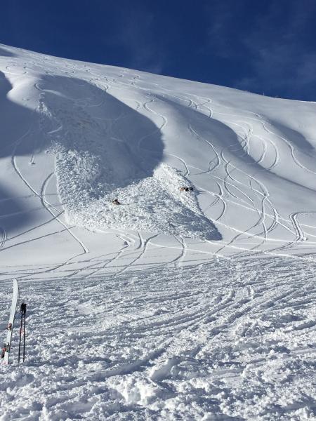
Sled triggered avalanches from Tuesday in the central Bear River Range. (Steam Mill and Christmas Tree Zollinger, Lundahl 1-19-2016)
A couple triggered avalanches occurred in the Providence Canyon Area on Thursday.....(1-21-2016)
|
 |
recent activity
The rider who triggered this avalanche in the Rodeo Grounds in Providence Canyon was carried and partially buried. (Wolford 1-21-16)
***To view our updated list of backcountry observations and avalanche activity from around Utah, go to our observations page
|
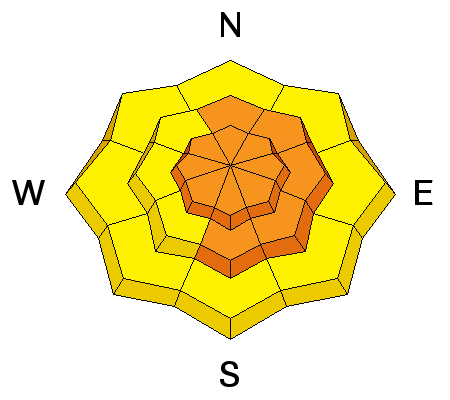
| type | aspect/elevation | characteristics |
|---|

|
|
LIKELIHOOD
 LIKELY
UNLIKELY
SIZE
 LARGE
SMALL
TREND
 INCREASING DANGER
SAME
DECREASING DANGER
|
|
description
Triggered persistent slab avalanches remain likely in some areas today.
***Pay close attention to signs of unstable snow like recent avalanches, whumpfing, and shooting cracks, and be willing to reevaluate your plans. In these conditions you could trigger avalanches remotely, from a distance or worse, from below!
|
| type | aspect/elevation | characteristics |
|---|

|

|
LIKELIHOOD
LIKELY
UNLIKELY
SIZE
 LARGE
SMALL
TREND
 INCREASING DANGER
SAME
DECREASING DANGER
|
|
description
Watch for and avoid recent and developing drifts and/or wind slabs near ridge tops and in and around terrain features like gullies, sub-ridges, scoops, and rock outcroppings.
|
 |
weather Snow is likely this afternoon in the mountains with a high temperature at 8500' pushing 30 degrees and a moderate south wind. It will snow tonight, with a low around 18 degrees and west winds. 3 to 5 inches of accumulation is possible. Snow showers will continue tomorrow and another inch or two is possible. A cool northerly flow will follow for the first part of next week. High pressure conditions will develop over the region for latter in the week. |
| general announcements The CROWBAR backcountry ski race will be Saturday January 30. More info at http://CrowbarSkiRace.org. Please submit snow and avalanche observations from your ventures in the backcountry HERE. You can call us at 801-524-5304 or email HERE, or include #utavy in your Instagram or Tweet us @UAClogan. To report avalanche activity in the Logan Area or to contact the local avalanche forecaster call me, Toby, at 435-757-7578. I'll update this advisory throughout the season on Monday, Wednesday, Friday, and Saturday mornings by about 7:30 This advisory is produced by the U.S.D.A. Forest Service, which is solely responsible for its content. It describes only general avalanche conditions and local variations always exist. |


.jpg)