| Please join us at the 23rd annual Black Diamond Fall Fundraiser Party Thursday Sept 15. Tickets are on sale now here, at the Black Diamond store & at REI. Special bonus raffle for online ticket purchasers! |
| Please join us at the 23rd annual Black Diamond Fall Fundraiser Party Thursday Sept 15. Tickets are on sale now here, at the Black Diamond store & at REI. Special bonus raffle for online ticket purchasers! |
| Advisory: Logan Area Mountains | Issued by Toby Weed for Thursday - January 21, 2016 - 6:24am |
|---|

|
bottom line HIGH (level 4): Very dangerous avalanche conditions exist in the backcountry and people should avoid travel in avalanche terrain. Large and destructive triggered avalanches are likely on recently drifted slopes steeper than about 30 degrees. Natural activity is quite possible due to rapid warming and strong solar radiation. Avoid travel on or beneath steep slopes and obvious or historic avalanche paths. Avalanches could be triggered remotely, from a distance or even below!
|
 |
avalanche warning THE FOREST SERVICE UTAH AVALANCHE CENTER IN SALT LAKE CITY HAS CONTINUED A BACKCOUNTRY AVALANCHE WARNING. * TIMING…IN EFFECT FROM 6 AM MST THIS MORNING TO 6 AM MST FRIDAY * AFFECTED AREA…FOR THE MOUNTAINS OF NORTHERN AND CENTRAL UTAH AND SOUTHEASTERN IDAHO INCLUDING THE WASATCH RANGE...BEAR RIVER RANGE...WESTERN UINTA RANGE...AND MANTI-SKYLINE PLATEAU. * AVALANCHE DANGER…THE AVALANCHE DANGER IS HIGH TODAY. * IMPACTS…VERY DANGEROUS AVALANCHE CONDITIONS EXIST. MANY AVALANCHES HAVE OCCURRED OVER THE LAST TWO DAYS AND MORE ARE LIKELY TODAY DUE TO RECENT SNOWFALL AND STRONG WINDS. STAY OFF OF AND OUT FROM UNDER SLOPES STEEPER THAN 30 DEGREES. BACKCOUNTRY TRAVELERS SHOULD CONSULTWWW.UTAHAVALANCHECENTER.ORG OR CALL 1-888-999-4019 FOR MORE DETAILED INFORMATION. |
 |
current conditions Dangerous avalanche conditions still exist today on previously drifted slopes in the backcountry, and you should stay off of and out from under slopes steeper than about 30 degrees. The temperature is 17 degrees and I'm reading about 6 inches of new snow in the last 24 hrs, containing .7" of water at the 8400' Tony Grove Snotel. There's now 69 inches of total snow, containing 102% of average water content for the date. The 9700' CSI Logan Peak weather station reports 11 degrees this morning and a rimed wind sensor. The UDOT Hwy 89 summit weather station reports greatly diminished WNW wind overnight with current wind speed in the lower single digits.
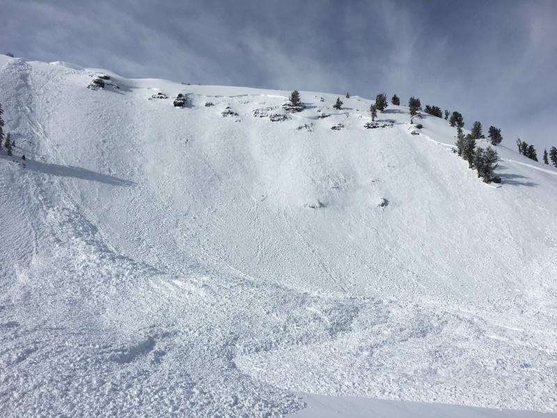
A large sled triggered avalanche from yesterday in Christmas Tree Bowl just north of Naomi Peak in Bullen Basin. The avalanche was triggered from very low on the slope. (J. Lundahl 1-19-2016)
|
 |
recent activity
Looks like a large natural avalanche in Old Logway slammed Maple Bench overnight or early Wednesday morning. (Pagnucco 1-20-2016) ***To view our updated list of backcountry observations and avalanche activity from around Utah, go to our observations page
|
| type | aspect/elevation | characteristics |
|---|

|

|
LIKELIHOOD
 LIKELY
UNLIKELY
SIZE
 LARGE
SMALL
TREND
 INCREASING DANGER
SAME
DECREASING DANGER
|
|
description
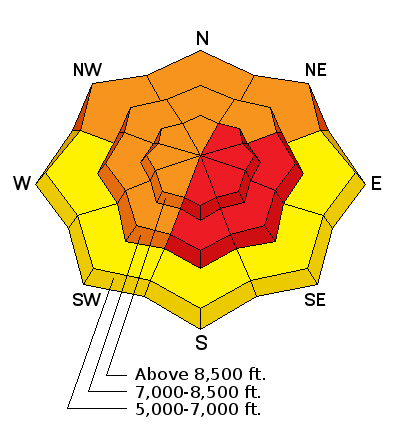
Last week, we found widespread loose and very weak snow on the surface, and now a slab layer consisting of drifted new snow has accumulated on it. Triggered persistent slab avalanches are likely in some areas today, and last week's weak surface snow is now a buried persistent weak layer that could stay reactive for several days at least. Avalanches are possible on steep slopes with significant recent accumulations even in sheltered terrain and at lower elevations. In some areas, the faceted snow in the basal layers of the snowpack may become reactivated by the recently added weight of drifted new snow. Dangerous and destructive avalanches involving old snow and failing on sugary faceted snow or depth hoar are possible today, especially in areas with shallow snow cover and poor snow structure. Natural avalanches are possible with rapid warming and strong sun today. ***Pay close attention to signs of unstable snow like recent avalanches, whumpfing, and shooting cracks, and be willing to reevaluate your plans. In these conditions you could trigger avalanches remotely, from a distance or worse, from below!
|
| type | aspect/elevation | characteristics |
|---|

|
|
LIKELIHOOD
LIKELY
UNLIKELY
SIZE
 LARGE
SMALL
TREND
 INCREASING DANGER
SAME
DECREASING DANGER
|
|
description
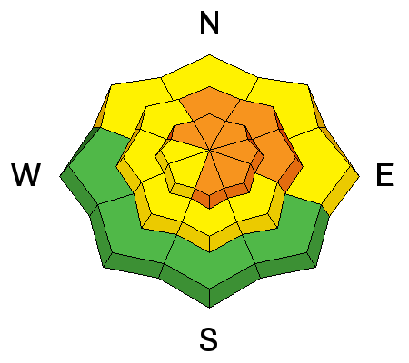
Avoid recent drifts and/or stiffer wind slabs near ridge tops and in and around terrain features like gullies, sub-ridges, scoops, and rock outcroppings. Wind slabs probably formed on weak faceted or feathery snow that was previously on the snow surface, which means the slabs could be reactive to our weight, and the older drifts may stay sensitive to human triggering for several days.
|
| type | aspect/elevation | characteristics |
|---|

|
|
LIKELIHOOD
LIKELY
UNLIKELY
SIZE
LARGE
SMALL
TREND
 INCREASING DANGER
SAME
DECREASING DANGER
|
|
description
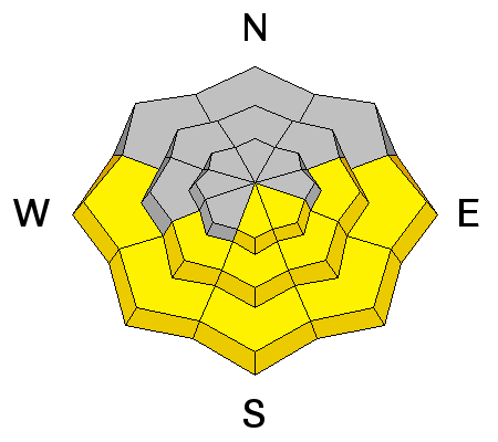
Rapid warming and strong sun today could cause a problem with wet activity. Sluffs and roller balls might be visible signs of this instability, but if the snow you're in gets saturated due to warmth, you'll want to move off and out from under steep slopes. |
 |
weather It'll be mostly sunny in the mountains with a high temperature at 8500' around 28 degrees and fairly light west wind. Expect mostly cloudy conditions tonight, with a low around 21 degrees and the light west wind veering from the south after midnight. Should be partly sunny and quite warm tomorrow, with a high close to 40 degrees and south-southwest winds averaging in the mid teens. The next round of winter weather is expected this weekend, starting on Saturday, and continuing through Sunday, with moderate accumulations possible in the mountains. |
| general announcements Presenting our Avalanche Awareness Class in Logan beginning the January 21, with a full field day in the backcountry on Saturday January 23. Go HERE for more information and to sign up. The CROWBAR backcountry ski race will be Saturday January 30. More info at http://CrowbarSkiRace.org. Please submit snow and avalanche observations from your ventures in the backcountry HERE. You can call us at 801-524-5304 or email HERE, or include #utavy in your Instagram or Tweet us @UAClogan. To report avalanche activity in the Logan Area or to contact the local avalanche forecaster call me, Toby, at 435-757-7578. I'll update this advisory throughout the season on Monday, Wednesday, Friday, and Saturday mornings by about 7:30 This advisory is produced by the U.S.D.A. Forest Service, which is solely responsible for its content. It describes only general avalanche conditions and local variations always exist. |